11.5 km
~3 hrs 3 min
455 m
“Immerse yourself in the Waldschluchtenweg Loop's captivating landscapes and historical ruins near Mayen-Koblenz.”
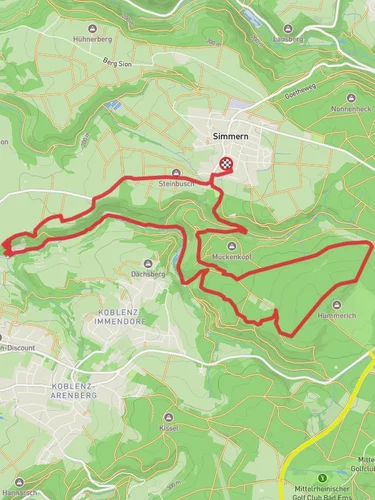
Starting near the picturesque town of Mayen-Koblenz in Germany, the Waldschluchtenweg Loop is a captivating 11 km (approximately 6.8 miles) trail that offers a moderate challenge with an elevation gain of around 400 meters (about 1,312 feet). This loop trail is perfect for those looking to immerse themselves in the natural beauty and historical richness of the region.
### Getting There To reach the trailhead, you can either drive or use public transportation. If driving, set your GPS to Mayen-Koblenz, and look for parking near the town center or designated trail parking areas. For those using public transport, take a train to Mayen West station. From there, local buses or a short taxi ride can get you to the trailhead.
### Trail Highlights The Waldschluchtenweg Loop is renowned for its diverse landscapes, ranging from dense forests to open meadows and dramatic rock formations. As you embark on this journey, you'll traverse through lush woodlands that are home to a variety of wildlife, including deer, foxes, and numerous bird species. Keep your eyes peeled for the vibrant flora, especially during spring and summer when wildflowers are in full bloom.
#### Historical Significance One of the most intriguing aspects of this trail is its historical significance. The region around Mayen-Koblenz has been inhabited since Roman times, and remnants of this ancient past can still be seen along the trail. Approximately 3 km (1.9 miles) into the hike, you'll come across the ruins of a Roman watchtower, offering a glimpse into the area's strategic importance in antiquity.
### Navigation and Waypoints Using HiiKER for navigation is highly recommended to ensure you stay on track. The trail is well-marked, but having a reliable navigation tool can help you identify key waypoints and avoid any potential detours.
#### Notable Landmarks - Roman Watchtower Ruins: Located about 3 km (1.9 miles) from the start, these ruins are a must-see for history enthusiasts. - Panoramic Viewpoint: Around the 6 km (3.7 miles) mark, you'll reach a stunning viewpoint that offers panoramic views of the surrounding valleys and forests. This is an excellent spot for a rest and some photography. - Forest Streams: As you continue, you'll encounter several small streams and brooks, particularly around the 8 km (5 miles) point. These serene water features add to the trail's charm and provide a refreshing ambiance.
### Wildlife and Flora The trail's diverse ecosystems support a wide range of wildlife. Early morning hikers might spot deer grazing in the meadows, while birdwatchers can enjoy sightings of woodpeckers, owls, and various songbirds. The forest floor is often carpeted with wildflowers, ferns, and mosses, creating a vibrant and ever-changing tapestry of colors.
### Trail Conditions and Safety The Waldschluchtenweg Loop is rated as medium difficulty, making it suitable for hikers with a moderate level of fitness. The trail can be muddy and slippery after rain, so sturdy hiking boots with good grip are essential. Carrying a basic first aid kit, sufficient water, and snacks is advisable. Always check the weather forecast before heading out and inform someone of your plans.
### Final Stretch As you near the end of the loop, the trail gently descends back towards Mayen-Koblenz, offering a relaxing conclusion to your hike. The final 2 km (1.2 miles) are relatively easy, allowing you to cool down and reflect on the natural and historical wonders you've experienced.
Whether you're a seasoned hiker or a nature enthusiast, the Waldschluchtenweg Loop provides a fulfilling adventure through one of Germany's most enchanting landscapes.
Reviews
User comments, reviews and discussions about the Waldschluchtenweg Loop, Germany.
4.0
average rating out of 5
6 rating(s)


