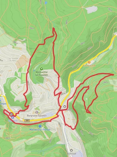
Judenkopf Hill Walk via Theodor Fliedner Weg
13.8 km
~3 hrs 40 min
545 m
“Explore the Judenkopf Hill Walk: 14 kilometers of scenic beauty, historical landmarks, and moderate hiking challenges.”
Starting near Main-Taunus-Kreis, Germany, the Judenkopf Hill Walk via Theodor Fliedner Weg is an invigorating out-and-back trail stretching approximately 14 kilometers (8.7 miles) with an elevation gain of around 500 meters (1,640 feet). This medium-difficulty hike offers a blend of natural beauty, historical significance, and moderate physical challenge.
### Getting There To reach the trailhead, you can drive or use public transport. If driving, set your GPS to the vicinity of Main-Taunus-Kreis, specifically near the Theodor Fliedner Weg. For public transport, the nearest significant landmark is the Hofheim (Taunus) train station. From there, local buses or a short taxi ride will get you to the trailhead.
### Trail Overview The trail begins with a gentle ascent through mixed forests, providing ample shade and a serene atmosphere. Early on, you'll encounter well-marked paths, making navigation straightforward. Using HiiKER can further ensure you stay on track.
### Key Landmarks and Points of Interest - Theodor Fliedner Weg: Named after the founder of the Kaiserswerth Deaconess Institute, this path is rich in history. The trailhead itself is a nod to Fliedner's contributions to social work and nursing. - Judenkopf Hill: At approximately 7 kilometers (4.35 miles) in, you'll reach Judenkopf Hill, the highest point of the hike. The summit offers panoramic views of the surrounding Taunus region, a perfect spot for a rest and some photography. - Historical Sites: Along the way, you may notice remnants of old fortifications and markers that date back to various periods of German history. These are often accompanied by informational plaques detailing their significance.
### Flora and Fauna The trail is abundant with diverse plant life, including oak, beech, and pine trees. In spring and summer, wildflowers add a splash of color to the landscape. Wildlife enthusiasts might spot deer, foxes, and a variety of bird species, making it a rewarding experience for nature lovers.
### Elevation and Terrain The initial part of the trail is relatively flat, but as you progress, the elevation gain becomes more noticeable. The ascent to Judenkopf Hill is steady but manageable, with a few steeper sections that require careful footing. The total elevation gain is around 500 meters (1,640 feet), spread out over the course of the hike.
### Practical Tips - Footwear: Sturdy hiking boots are recommended due to the varied terrain. - Weather: Check the weather forecast before heading out, as conditions can change rapidly in the Taunus region. - Supplies: Carry enough water and snacks, especially if you plan to spend time at the summit. - Navigation: While the trail is well-marked, having HiiKER on your device can provide additional peace of mind.
### Return Journey The return journey follows the same path, allowing you to revisit any points of interest you might have missed on the way up. The descent is generally easier, but still requires attention to footing, especially in wet conditions.
This hike offers a balanced mix of physical challenge, natural beauty, and historical intrigue, making it a rewarding experience for medium-level hikers.
Reviews
User comments, reviews and discussions about the Judenkopf Hill Walk via Theodor Fliedner Weg, Germany.
5.0
average rating out of 5
1 rating(s)


