13.7 km
~3 hrs 29 min
452 m
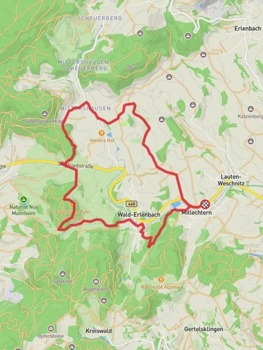
“Experience the scenic, historical, and wildlife-rich 14 km Hambacher Grenzweg and Igelsbachstraße Loop in Kreis Bergstraße.”
Starting near Kreis Bergstraße, Germany, the Hambacher Grenzweg and Igelsbachstraße Loop is a captivating 14 km (8.7 miles) loop trail with an elevation gain of approximately 400 meters (1,312 feet). This medium-difficulty trail offers a blend of natural beauty, historical significance, and diverse wildlife, making it a rewarding experience for hikers.
### Getting There To reach the trailhead, you can either drive or use public transport. If driving, set your GPS to Kreis Bergstraße, Germany, where ample parking is available near the trailhead. For those using public transport, take a train to Heppenheim (Bergstraße) station, which is the nearest major station. From there, you can catch a local bus or taxi to the trailhead.
### Trail Overview The trail begins with a gentle ascent through lush forests, offering a serene start to your hike. As you progress, the path becomes steeper, leading you to the first significant landmark, the Hambach Castle. This historic castle, perched atop a hill, offers panoramic views of the surrounding landscape and is a perfect spot for a short break.
### Historical Significance Hambach Castle is not just a visual treat but also a site of historical importance. It was the location of the Hambach Festival in 1832, a pivotal event in the German democracy movement. The castle's museum provides insights into this period, making it a worthwhile stop for history enthusiasts.
### Nature and Wildlife Continuing along the trail, you'll traverse through dense forests and open meadows, each offering unique flora and fauna. Keep an eye out for deer, foxes, and a variety of bird species that inhabit the area. The trail is particularly beautiful in spring and autumn when the foliage is vibrant.
### Midpoint and Elevation Around the 7 km (4.3 miles) mark, you'll reach the highest point of the trail, offering stunning views of the Odenwald and the Rhine Valley. This section involves an elevation gain of about 200 meters (656 feet) from the trailhead, so be prepared for a bit of a climb. The effort is well worth it for the breathtaking vistas.
### Navigation and Safety The trail is well-marked, but it's always a good idea to have a reliable navigation tool. HiiKER is an excellent app for this purpose, providing detailed maps and real-time updates. Ensure you have adequate water and snacks, as there are limited facilities along the route.
### Final Stretch The descent begins after the midpoint, leading you through the picturesque Igelsbachstraße. This part of the trail is less strenuous and allows you to enjoy the tranquil surroundings. As you loop back towards the starting point, you'll pass through charming villages and vineyards, offering a glimpse into the local culture and lifestyle.
### Practical Tips Wear sturdy hiking boots, as some sections can be rocky and uneven. The trail is accessible year-round, but the best times to hike are late spring and early autumn when the weather is mild. Always check the weather forecast before setting out and dress in layers to accommodate changing conditions.
This trail offers a perfect blend of natural beauty, historical intrigue, and moderate physical challenge, making it an ideal choice for hikers looking to explore the scenic and historical landscapes of Kreis Bergstraße.
Reviews
User comments, reviews and discussions about the Hambacher Grenzweg and Igelsbachstraße Loop, Germany.
4.0
average rating out of 5
1 rating(s)


