12.4 km
~2 hrs 57 min
283 m
“Embark on a medium-difficulty trek through lush Thuringian Forest, rich in history and serene beauty.”
Starting your journey near Ilm-Kreis, Germany, the Altenfeld to Schwarzmuehle via Hirschgrund trail offers a delightful 12 km (approximately 7.5 miles) trek through the Thuringian Forest. With an elevation gain of around 200 meters (about 656 feet), this point-to-point trail is estimated to be of medium difficulty, making it suitable for hikers with some experience.
### Getting There
To reach the trailhead, you can drive to the vicinity of Altenfeld, which is accessible via the A71 motorway. For those relying on public transport, the nearest significant town is Ilmenau, which is well-connected by train. From Ilmenau, you can take a local bus or taxi to Altenfeld, ensuring a convenient start to your hiking adventure.
### Trail Highlights
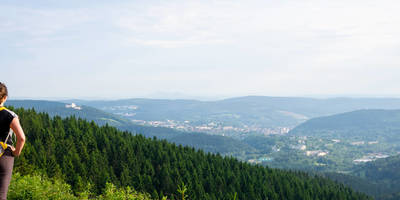
As you embark on this scenic hike, you'll traverse a landscape rich in natural beauty and historical significance. The Thuringian Forest is renowned for its dense woodlands, offering a serene backdrop of towering trees and lush undergrowth. Keep an eye out for native wildlife, including deer and various bird species, which are often spotted along the trail.
#### Hirschgrund
Approximately halfway through your hike, you'll pass through the Hirschgrund area, a picturesque valley known for its tranquil atmosphere. This section of the trail provides a gentle descent, allowing you to enjoy the surrounding flora and fauna. The name "Hirschgrund" translates to "Deer Ground," hinting at the wildlife you might encounter.
#### Historical Context
The region is steeped in history, with the Thuringian Forest serving as a natural barrier and strategic location throughout various historical periods. During the Middle Ages, this area was part of important trade routes, and remnants of old paths and settlements can still be found. The forest also played a role during the Cold War, as it was near the border between East and West Germany.
### Navigation and Safety
For navigation, the HiiKER app is an excellent tool to ensure you stay on track. The trail is generally well-marked, but having a reliable map can enhance your hiking experience. Be prepared for varying weather conditions, as the forest can be quite cool and damp, even in summer. Proper footwear and layered clothing are recommended.
### Final Stretch to Schwarzmuehle
As you approach the end of your hike, the trail leads you to Schwarzmuehle, a charming area known for its traditional German architecture and hospitality. Here, you can relax and enjoy local cuisine, reflecting on the diverse landscapes and historical insights encountered along the way.
Reviews
User comments, reviews and discussions about the Altenfeld to Schwarzmuehle via Hirschgrund, Germany.
5.0
average rating out of 5
6 rating(s)


