11.7 km
~2 hrs 48 min
273 m
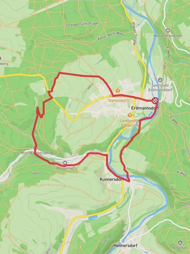
“Explore Erzgebirgskreis's beauty and history on the 12 km Dittmannsdorf to Kunnersdorf Loop.”
Starting your hike near Erzgebirgskreis, Germany, the Dittmannsdorf to Kunnersdorf Loop offers a delightful 12 km (7.5 miles) journey with an elevation gain of around 200 meters (656 feet). This medium-difficulty loop trail provides a mix of natural beauty, historical landmarks, and a glimpse into the local wildlife.
### Getting There To reach the trailhead, you can drive or use public transport. If driving, set your GPS to Erzgebirgskreis, Germany, and look for parking near the village of Dittmannsdorf. For public transport, take a train to the nearest major station, Chemnitz Hauptbahnhof, and then a local bus towards Dittmannsdorf. The bus ride offers scenic views of the Erzgebirge (Ore Mountains) region, setting the mood for your hike.
### Trail Overview The trail begins in Dittmannsdorf, a quaint village known for its traditional Saxon architecture. As you start your hike, you'll be greeted by rolling hills and dense forests, typical of the Erzgebirge region. The first 3 km (1.9 miles) are relatively flat, making it an excellent warm-up as you traverse through meadows and small patches of woodland.
### Historical Significance Around the 4 km (2.5 miles) mark, you'll come across remnants of old mining operations. The Erzgebirge region has a rich mining history dating back to the 12th century, primarily for silver and tin. These historical sites offer a glimpse into the past and are often accompanied by informational plaques detailing the area's mining heritage.
### Nature and Wildlife As you continue, the trail ascends gradually, gaining about 100 meters (328 feet) in elevation over the next 2 km (1.2 miles). This section takes you through dense forests where you might spot local wildlife such as deer, foxes, and various bird species. Keep an eye out for the European Green Woodpecker, a common sight in these woods.
### Midpoint: Kunnersdorf Reaching the village of Kunnersdorf at around the 6 km (3.7 miles) mark, you'll find a perfect spot to rest and perhaps enjoy a picnic. Kunnersdorf is known for its charming church and traditional German houses. The village offers a peaceful respite before you begin your return journey.
### Return Journey The return leg of the loop takes you through a different route, offering new scenery and experiences. The trail descends gradually, losing the 100 meters (328 feet) of elevation you gained earlier. This section is about 4 km (2.5 miles) long and takes you through open fields and along small streams, providing a serene backdrop for the final stretch of your hike.
### Final Stretch The last 2 km (1.2 miles) bring you back to Dittmannsdorf, completing the loop. This section is relatively flat and easy, allowing you to cool down and reflect on the diverse landscapes and historical sites you've encountered.
### Navigation For navigation, it's highly recommended to use the HiiKER app, which provides detailed maps and real-time updates to ensure you stay on track. The app also highlights points of interest and offers information on elevation changes, making it an invaluable tool for this hike.
This trail offers a balanced mix of natural beauty, historical intrigue, and moderate physical challenge, making it a rewarding experience for hikers of all levels.
Reviews
User comments, reviews and discussions about the Dittmannsdorf to Kunnersdorf Loop, Germany.
5.0
average rating out of 5
1 rating(s)


