14.9 km
~3 hrs 57 min
583 m
“Embark on a scenic hike through history, nature, and panoramic vistas in Germany's Donnersbergkreis region.”
Nestled in the scenic region of Donnersbergkreis, Germany, this trail offers a captivating journey from Dannenfels to Bastenhaus via the majestic Donnersberg. Spanning approximately 15 kilometers (about 9.3 miles), this point-to-point trail is a delightful exploration for those seeking a medium-difficulty hike with an elevation gain of around 500 meters (approximately 1,640 feet).
### Getting There
To reach the trailhead near Donnersbergkreis, you can opt for public transport or drive. If you're using public transport, the nearest major city is Kaiserslautern. From there, you can take a regional train to Kirchheimbolanden and then a local bus to Dannenfels. For those driving, Dannenfels is accessible via the A63 motorway, with ample parking available near the trailhead.
### Trail Highlights
Donnersberg Mountain
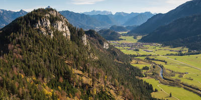
The trail's highlight is undoubtedly the Donnersberg, the highest peak in the Palatinate region, standing at 687 meters (2,254 feet). As you ascend, you'll be rewarded with panoramic views of the surrounding landscapes. The mountain is steeped in history, with remnants of Celtic fortifications dating back to the 4th century BC. These ancient ruins offer a glimpse into the region's rich past and are a must-see for history enthusiasts.
Flora and Fauna
The trail meanders through lush forests and open meadows, providing a diverse range of flora and fauna. In spring and summer, the meadows burst into color with wildflowers, while the forests are home to a variety of bird species. Keep an eye out for deer and other wildlife that inhabit the area.
Landmarks and Points of Interest
As you progress along the trail, you'll encounter several notable landmarks. The Adlerbogen, a large archway, offers a perfect spot for a rest and photo opportunity. Further along, the Ludwigsturm, a historic tower, provides an excellent vantage point to soak in the expansive views of the Palatinate Forest.
### Navigation and Safety
The trail is well-marked, but it's always wise to have a reliable navigation tool. HiiKER is recommended for its detailed maps and real-time updates. Ensure you have adequate water and snacks, as the trail can be demanding, especially during the ascent to Donnersberg. Weather conditions can change rapidly, so pack layers and be prepared for cooler temperatures at higher elevations.
### Ending Your Hike
The trail concludes at Bastenhaus, a quaint village where you can relax and enjoy some local cuisine. From Bastenhaus, you can arrange transportation back to your starting point or continue exploring the charming villages of the Donnersbergkreis region.
Reviews
User comments, reviews and discussions about the Dannenfels to Bastenhaus via Donnersberg, Germany.
5.0
average rating out of 5
4 rating(s)


