12.2 km
~2 hrs 32 min
63 m
“Explore Cologne's urban and natural beauty on a 12 km trail from Heinrich-Lübke-Ufer to Siegfriedstraße.”
Starting near Cologne, Germany, this 12 km (7.5 miles) point-to-point trail from Heinrich-Lübke-Ufer to Siegfriedstraße via Kölnpfad offers a delightful mix of urban and natural landscapes. With no significant elevation gain, this trail is accessible to most hikers, though it is rated as medium difficulty due to its length and varied terrain.
### Getting There To reach the trailhead at Heinrich-Lübke-Ufer, you can take public transport from Cologne's city center. The nearest tram stop is Heinrich-Lübke-Ufer, serviced by tram line 16. If you prefer to drive, there are parking facilities available near the starting point.
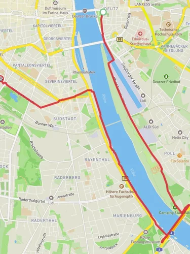
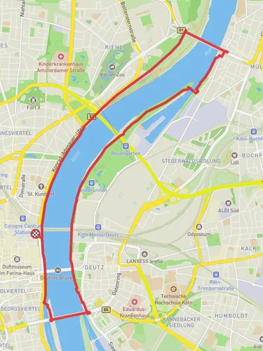
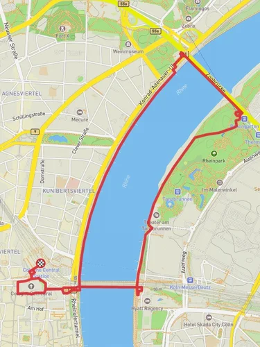
### Trail Overview The trail begins at Heinrich-Lübke-Ufer, a scenic riverside area along the Rhine. As you start your hike, you'll be treated to views of the river and the bustling activity of Cologne's waterfront. This section is relatively flat and easy, making it a pleasant start to your journey.
### Key Landmarks and Sections - Rhine River Views (0-2 km / 0-1.2 miles): The initial stretch along the Rhine offers picturesque views and a chance to observe local birdlife. Keep an eye out for swans and ducks that frequent the riverbanks. - Poller Wiesen (2-4 km / 1.2-2.5 miles): As you continue, you'll pass through Poller Wiesen, a large riverside park popular with locals for picnicking and recreational activities. This is a great spot to take a short break and enjoy the open green spaces. - Rodenkirchen Bridge (4-6 km / 2.5-3.7 miles): Crossing under the Rodenkirchen Bridge, you'll notice the impressive engineering of this suspension bridge, which connects the districts of Rodenkirchen and Marienburg. This area is also rich in history, as the bridge was originally built in the 1930s and reconstructed after World War II.
### Nature and Wildlife As you move away from the urban areas, the trail takes you through more wooded sections and open fields. The diversity of habitats along the Kölnpfad means you might encounter a variety of wildlife, including deer, foxes, and numerous bird species. The trail is particularly beautiful in spring and autumn when the foliage is vibrant.
### Historical Significance The Kölnpfad itself is a long-distance hiking trail that encircles the city of Cologne. It was established to promote outdoor activities and to connect various historical and natural sites around the city. Along this section, you'll pass by remnants of Cologne's historical defenses and old farmsteads that tell the story of the region's agricultural past.
### Navigation For navigation, it's recommended to use the HiiKER app, which provides detailed maps and real-time updates. The trail is well-marked, but having a reliable navigation tool will ensure you stay on track, especially in the more wooded sections.
### Final Stretch The final part of the trail leads you through quiet residential areas before reaching Siegfriedstraße. This section is peaceful and offers a glimpse into local life away from the tourist hotspots. The endpoint at Siegfriedstraße is easily accessible by public transport, with several bus and tram lines connecting you back to the city center.
This trail offers a unique blend of urban and natural experiences, making it a rewarding hike for those looking to explore the diverse landscapes around Cologne.

Reviews
User comments, reviews and discussions about the Heinrich-Lübke-Ufer to Siegfriedstraße via Kölnpfad, Germany.
4.0
average rating out of 5
7 rating(s)