Download
Preview
Add to list
More
1043.2 km
~9 days
6975 m
Multi-Day
“Embark on a historic 648-mile trek across Germany, from Flensburg's northern plains to Perl's southern hills, steeped in culture and natural splendor.”
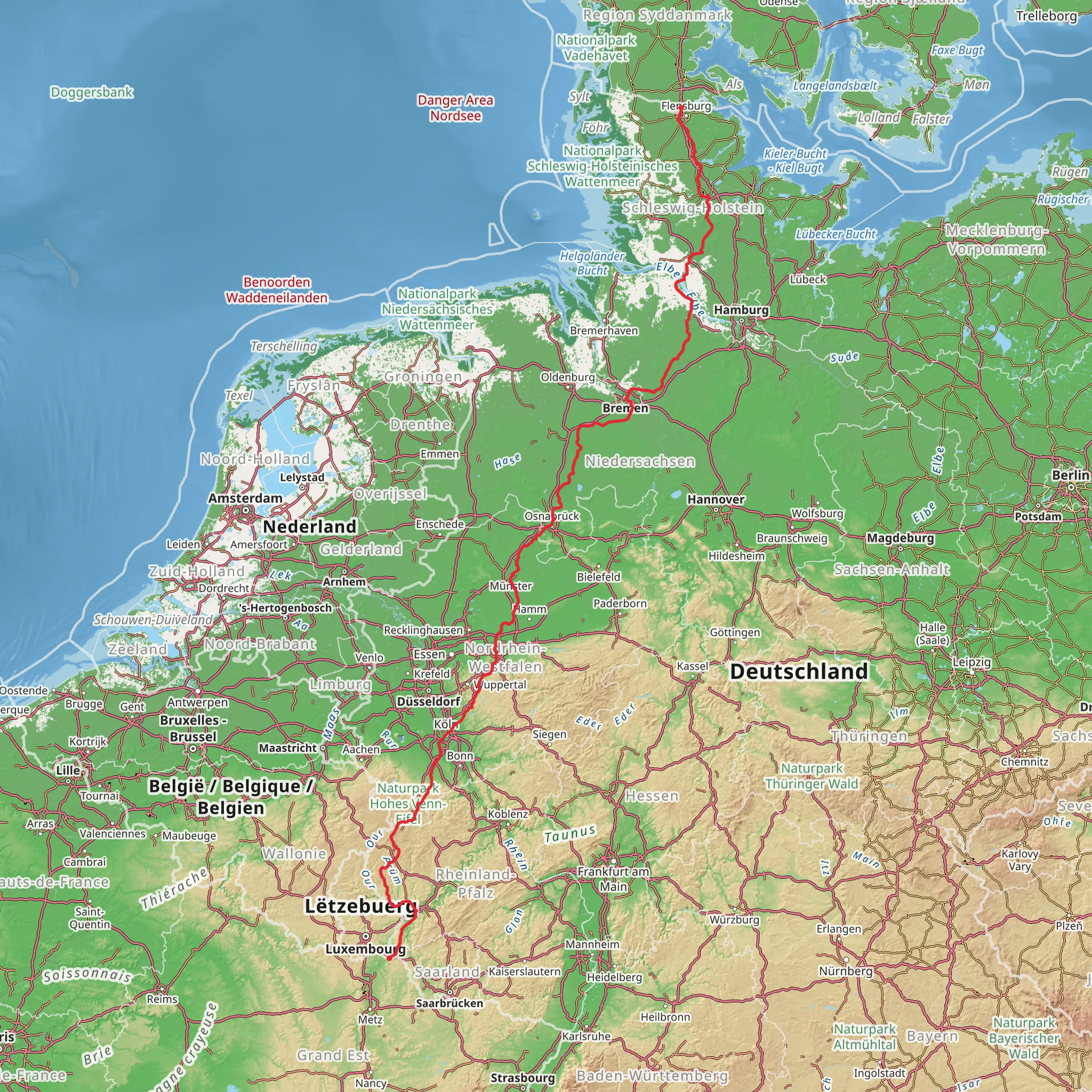
Spanning approximately 1043 kilometers (about 648 miles) with an elevation gain of around 6900 meters (approximately 22,965 feet), the Camino Flensburg-Perl via Bremen is a long-distance point-to-point trail that traverses a significant portion of Germany. Starting near Schleswig-Flensburg, hikers embark on a journey that will take them through diverse landscapes, historical towns, and cultural landmarks.
Getting to the Trailhead
To reach the starting point near Schleswig-Flensburg, hikers can use public transportation or drive. The nearest major city with an airport is Hamburg, from which you can take a train to Flensburg. If driving, you can navigate to the trailhead using HiiKER for precise directions. Parking is available in the area for those who choose to leave a vehicle.
Trail Overview
The trail begins in the northern region of Germany, where the terrain is relatively flat and the paths are well-marked. Hikers will pass through quaint villages and farmlands, with the opportunity to observe local wildlife such as deer and various bird species. The trail is rich in historical significance, as it crosses through areas that have been inhabited since the medieval times.
Cultural and Historical Landmarks
One of the highlights of the trail is the historic city of Bremen, which is roughly halfway through the hike. Bremen is known for its beautiful town square, the Marktplatz, and the UNESCO World Heritage Site of the Town Hall and Roland statue. The city's Schnoor quarter is a picturesque area with narrow lanes and traditional buildings that date back to the 15th and 16th centuries.
Natural Beauty and Wildlife
As the trail continues south, the landscape begins to change, and hikers will encounter the Teutoburg Forest, a range of wooded hills that is home to diverse flora and fauna. This region offers a more challenging terrain with steeper inclines and declines, contributing to the overall elevation gain of the trail.
Navigating the Trail
The trail is well-marked, but due to its length, it is recommended that hikers use HiiKER to keep track of their progress and ensure they are following the correct path. The app can also help locate nearby amenities such as water sources, campsites, and rest areas.
Preparation and Planning
Given the trail's length and varied terrain, hikers should be well-prepared with appropriate gear, including sturdy hiking boots, weather-appropriate clothing, and a reliable GPS device or smartphone with the HiiKER app installed. It's also advisable to carry a first-aid kit, sufficient food and water supplies, and a means of purifying water from natural sources.
Accommodation and Resupply Points
Throughout the trail, there are numerous towns and villages where hikers can find accommodation ranging from hostels to hotels. Resupply points for food and other essentials are also available in these areas, making it possible to hike the trail without carrying an excessive amount of provisions.
End of the Trail
The trail concludes in the town of Perl, located near the border with Luxembourg and France. From Perl, hikers can take public transportation to larger cities such as Saarbrücken or Trier, where they can continue their travels or return home.
Comments and Reviews
User comments, reviews and discussions about the Camino Flensburg-Perl via Bremen, Germany.
4.67
average rating out of 5
6 rating(s)

