Halsköpfl, Schwarzsee and Unterirdischer Abfluss via AV Weg
8.4 km
~2 hrs 58 min
781 m
“Embark on a scenic 8 km hike through the Bavarian Alps, rich in natural beauty and historical intrigue.”
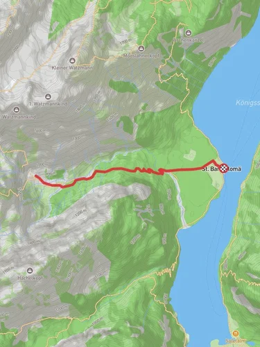
Starting near Berchtesgadener Land, Germany, this trail offers a captivating journey through the Bavarian Alps. The trailhead is accessible by car or public transport. If you're driving, you can park near the Berchtesgaden National Park. For those using public transport, take a train to Berchtesgaden Hauptbahnhof and then a bus to the nearest stop at Hintersee, Ramsau. From there, it's a short walk to the trailhead.
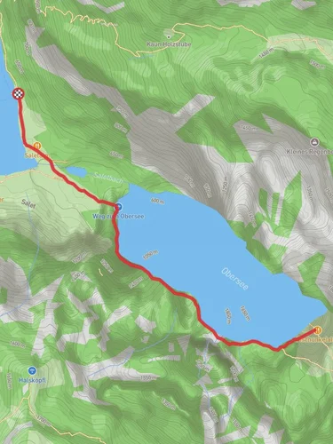
### Initial Ascent and Halsköpfl The trail begins with a steady ascent, gaining approximately 700 meters (2,300 feet) in elevation over the course of the hike. The first significant landmark is Halsköpfl, a scenic viewpoint that offers panoramic views of the surrounding mountains and valleys. This section of the trail is moderately challenging, with some steep inclines and rocky terrain. Hikers should be prepared with sturdy footwear and trekking poles for added stability.
### Schwarzsee Continuing from Halsköpfl, the trail leads you to Schwarzsee, a serene alpine lake situated around the halfway point of the hike. Schwarzsee is a perfect spot for a short break, allowing you to take in the tranquil waters and the lush greenery that surrounds it. The lake is home to various species of fish and is a popular spot for birdwatching. Keep an eye out for local wildlife such as deer and marmots, which are commonly seen in this area.
### Unterirdischer Abfluss The final segment of the trail takes you to the Unterirdischer Abfluss, an underground river that is a geological marvel. This part of the trail is relatively flat compared to the initial ascent, making it a bit easier on the legs. The underground river is a fascinating natural feature, and there are informational signs along the way that explain its formation and significance. This area is also rich in flora, with a variety of alpine plants and wildflowers dotting the landscape.
### Historical Significance The region around Berchtesgadener Land is steeped in history. During World War II, it was a significant location for the Nazi regime, with the infamous Eagle's Nest located nearby. Today, the area is a symbol of peace and natural beauty, attracting hikers and nature enthusiasts from around the world. The trail itself passes through parts of the Berchtesgaden National Park, which was established in 1978 to protect the unique alpine ecosystem.
### Navigation and Safety For navigation, it is highly recommended to use the HiiKER app, which provides detailed maps and real-time updates on trail conditions. The trail is well-marked, but having a reliable navigation tool will ensure you stay on the right path. Always check the weather forecast before heading out, as conditions in the mountains can change rapidly. Carry sufficient water, snacks, and a first-aid kit, and let someone know your hiking plans.
This 8 km (5 miles) point-to-point trail offers a blend of natural beauty, challenging terrain, and historical intrigue, making it a rewarding experience for medium-level hikers.

Reviews
User comments, reviews and discussions about the Halsköpfl, Schwarzsee and Unterirdischer Abfluss via AV Weg, Germany.
5.0
average rating out of 5
3 rating(s)