8.3 km
~1 hrs 42 min
37 m
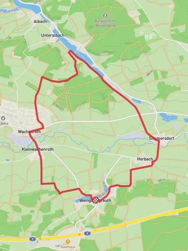
“The Weingartsgreuth Loop is an enchanting 8 km hike blending Franconian nature and medieval history.”
Starting near the charming town of Bamberg, Germany, the Weingartsgreuth Loop is an 8 km (approximately 5 miles) trail that offers a delightful mix of natural beauty and historical intrigue. With no significant elevation gain, this loop is accessible to a wide range of hikers, though it is rated as medium difficulty due to its length and varied terrain.
### Getting There To reach the trailhead, you can drive or use public transport. If driving, head towards the village of Weingartsgreuth, which is easily accessible from Bamberg via the A73 and B505 highways. For those using public transport, take a train to Bamberg and then a local bus towards Weingartsgreuth. The nearest significant landmark to the trailhead is the Weingartsgreuth Castle, a picturesque starting point for your hike.
### Trail Navigation The Weingartsgreuth Loop is well-marked, but it's always a good idea to have a reliable navigation tool. The HiiKER app is highly recommended for this purpose, offering detailed maps and real-time GPS tracking to ensure you stay on course.
### Points of Interest As you embark on the trail, you'll first encounter the lush, rolling fields that are characteristic of the Franconian countryside. About 2 km (1.2 miles) into the hike, you'll come across a small forested area, home to a variety of local wildlife including deer and numerous bird species. Keep your eyes peeled for the European robin and the great spotted woodpecker, both common in this region.
### Historical Significance Around the 4 km (2.5 miles) mark, you'll reach the village of Weingartsgreuth itself. This quaint village is steeped in history, with its roots tracing back to the medieval period. The Weingartsgreuth Castle, built in the 16th century, is a highlight. Though privately owned and not open to the public, its exterior is a marvel of Renaissance architecture and makes for a great photo opportunity.
### Flora and Fauna Continuing on, the trail meanders through more open fields and small patches of woodland. The flora here is diverse, with wildflowers such as the common poppy and cornflower adding splashes of color to the landscape. In the spring and summer months, the fields are alive with the buzzing of bees and the fluttering of butterflies, making it a delightful sensory experience.
### Final Stretch As you near the end of the loop, the trail takes you past a serene pond, a perfect spot for a short break. The pond is often frequented by ducks and other waterfowl, providing a peaceful backdrop as you rest. The final 2 km (1.2 miles) of the trail lead you back to the starting point near Weingartsgreuth Castle, completing your journey through this picturesque part of Germany.
### Practical Tips - Footwear: Given the varied terrain, sturdy hiking boots are recommended. - Weather: Check the local weather forecast before setting out, as the trail can become muddy after rain. - Supplies: Bring enough water and snacks, as there are no facilities along the trail. - Wildlife: Be respectful of the local wildlife; observe from a distance and do not feed the animals.
The Weingartsgreuth Loop offers a perfect blend of natural beauty, historical landmarks, and a moderate challenge, making it a rewarding hike for those looking to explore the Franconian countryside.
Reviews
User comments, reviews and discussions about the Weingartsgreuth Loop, Germany.
0.0
average rating out of 5
0 rating(s)


