Stallauer and Angerlkopf via Kleine Bergrunde and Wanderwegenetz Toelzer Land
10.1 km
~3 hrs 22 min
804 m
“Experience Bavarian beauty and history on this 10 km loop trail near Bad Tölz-Wolfratshausen.”
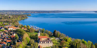
Starting near the picturesque town of Bad Tölz-Wolfratshausen in Germany, this loop trail spans approximately 10 km (6.2 miles) with an elevation gain of around 800 meters (2,625 feet). The trailhead is easily accessible by car or public transport. If you're driving, you can park near the town center of Bad Tölz. For those using public transport, take a train to Bad Tölz station and then a local bus or taxi to the trailhead.
### Initial Ascent and Terrain
The trail begins with a moderate ascent through dense forest, offering a serene start to your hike. The initial 2 km (1.2 miles) will see you gaining about 200 meters (656 feet) in elevation. The path is well-marked and maintained, making it suitable for hikers with a medium level of experience. As you climb, you'll notice the forest gradually giving way to more open terrain, providing glimpses of the surrounding Bavarian Alps.
### Key Landmarks and Views
Around the 3 km (1.9 miles) mark, you'll reach a clearing that offers panoramic views of the Isar Valley. This is an excellent spot for a short break and some photography. Continuing on, the trail leads you to the Stallauer Kopf, the first significant peak on this route. At an elevation of approximately 1,200 meters (3,937 feet), the summit provides breathtaking views of the Tölzer Land region.
### Flora and Fauna
The trail is rich in biodiversity. In the lower forested sections, you'll encounter a variety of deciduous trees, including beech and oak. As you ascend, the vegetation shifts to coniferous forests dominated by spruce and fir. Wildlife is abundant; keep an eye out for deer, foxes, and a variety of bird species, including the occasional golden eagle soaring above.
### Historical Significance
The region around Bad Tölz has a rich history dating back to Roman times. The town itself was a significant trading post in the Middle Ages, and remnants of this history can be seen in the architecture and local museums. The trail passes near several old farmhouses and chapels, offering a glimpse into the rural life of past centuries.
### Navigation and Safety
The trail is well-marked, but it's always a good idea to have a reliable navigation tool. HiiKER is an excellent app for this purpose, providing detailed maps and real-time tracking. The trail can be slippery in wet conditions, so sturdy hiking boots with good grip are recommended. Also, be prepared for sudden weather changes, as the region is known for its unpredictable mountain weather.
### Final Descent and Return
After reaching the Angerlkopf, the second peak at around 1,300 meters (4,265 feet), the trail begins its descent. The path down is a bit steeper and rockier, so take your time to ensure a safe descent. The final 3 km (1.9 miles) will take you through a mix of forest and meadow, eventually looping back to the trailhead near Bad Tölz.
This trail offers a perfect blend of natural beauty, historical intrigue, and moderate physical challenge, making it a rewarding experience for any hiker.

Reviews
User comments, reviews and discussions about the Stallauer and Angerlkopf via Kleine Bergrunde and Wanderwegenetz Toelzer Land, Germany.
0.0
average rating out of 5
0 rating(s)