4.6 km
~1 hrs 16 min
207 m
“The Kalmbach and Lainbach Loop offers a scenic 5 km hike with moderate difficulty near Bad Tölz-Wolfratshausen.”
Starting your adventure near Bad Tölz-Wolfratshausen, Germany, the Kalmbach and Lainbach Loop is a delightful 5 km (3.1 miles) loop trail with an elevation gain of approximately 200 meters (656 feet). This trail offers a medium difficulty rating, making it suitable for moderately experienced hikers.
### Getting There
To reach the trailhead, you can either drive or use public transport. If you're driving, set your GPS to Bad Tölz-Wolfratshausen and look for parking options near the trailhead. For those using public transport, take a train to Bad Tölz station. From there, you can catch a local bus or taxi to the trailhead, which is conveniently located near the town.
### Trail Overview
The trail begins with a gentle ascent through a mixed forest, where you'll be greeted by the soothing sounds of the Kalmbach stream. The first kilometer (0.6 miles) is relatively easy, allowing you to warm up and enjoy the lush greenery. As you continue, the trail becomes steeper, gaining about 100 meters (328 feet) in elevation over the next 1.5 kilometers (0.9 miles).
### Significant Landmarks
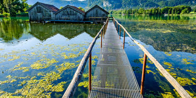
At around the 2 km (1.2 miles) mark, you'll come across a charming wooden bridge that crosses the Lainbach stream. This is a great spot to take a short break and enjoy the serene surroundings. The bridge itself is a picturesque landmark, perfect for photography enthusiasts.
### Flora and Fauna
The Kalmbach and Lainbach Loop is rich in biodiversity. Keep an eye out for various species of birds, including woodpeckers and songbirds. The forest floor is often carpeted with wildflowers in the spring and summer months, adding a splash of color to your hike. You might also spot deer and other small mammals if you're quiet and observant.
### Historical Significance
The region around Bad Tölz-Wolfratshausen has a rich history dating back to medieval times. The town of Bad Tölz itself is known for its well-preserved old town and traditional Bavarian architecture. While the trail doesn't have specific historical landmarks, the surrounding area is steeped in cultural heritage, making it a fascinating place to explore before or after your hike.
### Navigation
For navigation, it's highly recommended to use the HiiKER app, which provides detailed maps and real-time updates. The trail is well-marked, but having a reliable navigation tool can enhance your hiking experience and ensure you stay on the right path.
### Final Stretch
The last 1.5 km (0.9 miles) of the trail is a gentle descent back to the trailhead. This section offers beautiful views of the surrounding hills and valleys, making it a pleasant way to end your hike. As you approach the end, you'll pass through open meadows, which are particularly stunning during the golden hour.
This loop trail offers a perfect blend of natural beauty, moderate physical challenge, and a touch of local history, making it a must-visit for hikers in the region.
Reviews
User comments, reviews and discussions about the Kalmbach and Lainbach Loop, Germany.
5.0
average rating out of 5
4 rating(s)


