Download
3D Flyover
Add to list
More
34.9 km
~2 days
873 m
Multi-Day
“Embark on the Quinnipiac Trail's arduous journey through Connecticut's diverse landscapes, steeped in history and natural beauty.”
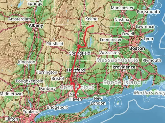
The Quinnipiac Trail, spanning approximately 35 kilometers (about 22 miles) with an elevation gain of around 800 meters (roughly 2600 feet), is a challenging point-to-point trek nestled in the scenic landscape near New Haven County, Connecticut. This trail is considered difficult due to its length and the significant elevation changes along the route.
Getting to the Trailhead
To embark on your journey along the Quinnipiac Trail, you can start at the southern terminus located close to the town of Hamden. If you're driving, you can park your car near the intersection of Hartford Turnpike and Downs Road. For those opting for public transportation, local bus services can get you close to the trailhead, and from there, a short taxi or ride-sharing service will bring you to the starting point.
Navigating the Trail
As you set out on the Quinnipiac Trail, you'll be greeted by the lush greenery of southern Connecticut. The trail is well-marked, but carrying a reliable navigation tool like HiiKER is advisable to keep track of your progress and ensure you're on the right path.
Landmarks and Scenery
The Quinnipiac Trail will lead you through a diverse array of landscapes, including dense forests, rocky ridges, and tranquil streams. One of the first significant landmarks you'll encounter is the Sleeping Giant State Park, which offers a stunning view of the surrounding area from the stone observation tower atop Mount Carmel. This park is roughly 5 kilometers (3 miles) from the trailhead.
As you continue, you'll traverse the Mill River, a serene waterway that adds to the trail's charm. The Quinnipiac Trail also winds through the Naugatuck State Forest, which is rich in wildlife and offers a chance to spot local fauna such as white-tailed deer, red foxes, and a variety of bird species.
Historical Significance
The region holds historical significance, with the trail itself being one of the oldest in the Connecticut Blue-Blazed Trail System. As you hike, you'll be walking paths that have been used for centuries, first by Native American tribes and later by colonial settlers.
Preparation and Safety
Given the trail's difficulty rating, it's essential to prepare adequately before setting out. Ensure you have enough water, high-energy food, and appropriate gear for the terrain and weather conditions. Sturdy hiking boots are a must, as the trail can be rocky and uneven in places. Additionally, it's wise to inform someone of your hiking plans and expected return time.
Seasonal Considerations
The Quinnipiac Trail can be hiked year-round, but each season offers a different experience. Spring and fall provide cooler temperatures and vibrant foliage, while summer is lush and full of life. Winter hikes can be beautiful but require caution due to snow and ice.
Remember, the Quinnipiac Trail is a point-to-point hike, so plan your transportation accordingly for when you reach the trail's end near the town of Prospect. Whether you arrange for a pick-up or use a shuttle service to return to your starting point, it's crucial to have a plan in place.

What to expect?
Activity types
Frequently asked questions
How long does it take to hike the Quinnipiac Trail in Connecticut?
The Quinnipiac Trail is 34.86 km, or about 21.7 miles, so most hikers treat it as a long full-day hike or a 2-day trip. With 873 m of elevation gain and repeated rocky ridge climbs through places like Sleeping Giant State Park, West Rock Ridge State Park, and Naugatuck State Forest, a through-hike commonly takes around 10 to 14 hours of moving time.
Where does the Quinnipiac Trail start and end in New Haven County?
The Quinnipiac Trail runs north-south through New Haven County and links several major open-space areas, including Sleeping Giant State Park, West Rock Ridge State Park, and Naugatuck State Forest. The currently recognized southern end is near Old Hartford Turnpike in Hamden, and the northern end follows the rocky ridgeline along the Prospect-Cheshire border.
What are the main landmarks on the Quinnipiac Trail?
The Quinnipiac Trail passes through some of central Connecticut’s best-known ridge and forest terrain. Key landmarks along the route include Sleeping Giant State Park, West Rock Ridge State Park, Naugatuck State Forest, Lake Wintergreen in the West Rock area, and the rocky ridgeline near Mount Sanford on the Prospect-Cheshire border.
Is the Quinnipiac Trail hard, and what kind of terrain does it have?
The Quinnipiac Trail is best described as a medium to challenging point-to-point hike because it covers 34.86 km with 873 m of climbing. The route is known for rocky ridges, wooded sections, uneven footing, and repeated short ascents and descents rather than one single sustained climb, especially through the traprock ridge sections in Hamden and the northern forested high ground.
Can the Quinnipiac Trail be hiked as an overnight trip?
Yes. At 34.86 km, the Quinnipiac Trail is long enough to split into 2 days, especially for hikers who want time at viewpoints in Sleeping Giant State Park or along the ridges farther north. It is a point-to-point route rather than a loop, so overnight planning usually also includes arranging a shuttle or a second vehicle between the Hamden side and the Prospect-Cheshire end.
Is there parking for the Quinnipiac Trail near Sleeping Giant State Park or West Rock Ridge?
Parking is available at access points along the Quinnipiac Trail, including areas connected to Sleeping Giant State Park and West Rock Ridge State Park, though some lots are limited in size. At Connecticut state parks, parking fees generally do not apply to Connecticut-registered vehicles, while out-of-state vehicles may be charged at certain parks on weekends and holidays, including Sleeping Giant.
Can you reach the Quinnipiac Trail by public transportation?
Public transit works best for the southern Quinnipiac Trail near Sleeping Giant State Park in Hamden. CTtransit Route 229 serves Whitney Avenue and Mount Carmel Avenue, about a 6-minute walk from the park entrance, which gives access to one of the best-known sections of the trail. More northern sections near Bethany, Cheshire, and Prospect are much less transit-friendly.
Comments and Reviews
User comments, reviews and discussions about the Quinnipiac Trail, Connecticut.
4.49
average rating out of 5
1708 rating(s)