11.0 km
~2 hrs 32 min
210 m
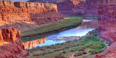
“The Jones Canyon Trail boasts scenic beauty, diverse wildlife, and historical landmarks, rewarding hikers with panoramic views.”
Starting near Mesa County, Colorado, the Jones Canyon Trail is an 11 km (approximately 6.8 miles) out-and-back trail with an elevation gain of around 200 meters (656 feet). This medium-difficulty trail offers a blend of scenic beauty, historical significance, and diverse wildlife, making it a rewarding experience for hikers.
### Getting There To reach the trailhead, you can drive or use public transport. If driving, head towards the nearest known address, which is the Mesa County Fairgrounds. From there, follow the signs to the trailhead. For those using public transport, take a bus to the Mesa County Fairgrounds and then a short taxi ride or a local shuttle to the trailhead.
### Trail Overview The trail begins with a gentle ascent through a mix of pinyon-juniper woodlands and sagebrush flats. As you progress, the path becomes rockier, so sturdy hiking boots are recommended. The initial 2 km (1.2 miles) are relatively easy, with a gradual elevation gain of about 50 meters (164 feet).
### Significant Landmarks Around the 3 km (1.9 miles) mark, you'll encounter a striking red rock formation known locally as "The Sentinel." This natural landmark offers a great spot for a short break and some photography. Continuing on, the trail winds through a narrow canyon, where the walls rise steeply on either side, creating a dramatic and picturesque setting.
### Flora and Fauna The Jones Canyon Trail is home to a variety of plant and animal species. Keep an eye out for mule deer, which are commonly seen grazing in the area. Birdwatchers will also enjoy spotting species like the Western Scrub-Jay and the Mountain Bluebird. The flora includes native wildflowers such as Indian Paintbrush and Lupine, especially vibrant in the spring and early summer.
### Historical Significance This region holds historical significance as it was once traversed by Native American tribes and later by early settlers. Evidence of ancient petroglyphs can be found on some of the rock faces along the trail, particularly around the 5 km (3.1 miles) point. These carvings offer a glimpse into the rich cultural history of the area.
### Navigation and Safety Given the rocky terrain and potential for sudden weather changes, it's advisable to use a reliable navigation tool like HiiKER to stay on track. The trail is well-marked, but having a digital map can provide extra assurance. Carry plenty of water, as there are no reliable water sources along the trail, and be prepared for limited shade in some sections.
### Final Stretch The final 2 km (1.2 miles) of the trail involve a steeper ascent, gaining about 100 meters (328 feet) in elevation. This section can be challenging, but the panoramic views from the top are well worth the effort. On a clear day, you can see the distant peaks of the Rocky Mountains, making it a perfect spot for a well-deserved rest before heading back.
The Jones Canyon Trail offers a mix of natural beauty, wildlife, and historical intrigue, making it a must-visit for hikers in the Mesa County area.

Reviews
User comments, reviews and discussions about the Jones Canyon Trail, Colorado.
0.0
average rating out of 5
0 rating(s)