DAYS
HOURS
MINS
SECS
SALE ENDS SOON!
DISCOUNT ON ALL PRO+ FEATURES
DAYS
HOURS
MINS
SECS
DISCOUNT ON ALL PRO+ FEATURES
7.7 km
4 h 54 m
399 m
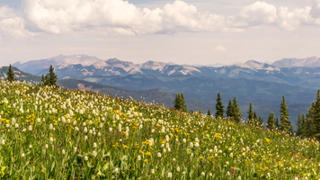
“Embark on a scenic and historic 8 km hike through Colorado's alpine Columbus Basin, brimming with wildlife and mining lore.”
Nestled in the heart of the San Juan Mountains near La Plata County, Colorado, the Columbus Basin trail offers an invigorating hike through alpine landscapes with a round trip distance of approximately 8 km (5 miles) and an elevation gain of around 300 meters (984 feet). This out-and-back trail is rated as medium difficulty, making it accessible to hikers with a reasonable level of fitness.
Getting to the Trailhead
To reach the trailhead, hikers can drive to the nearest known landmark, which is the town of Silverton, Colorado. From Silverton, you'll head north on US-550 for about 23 km (14 miles) until you reach the turnoff for County Road 4, also known as the Columbine Pass Road. The trailhead is accessible via a dirt road that may require a high-clearance vehicle, especially after heavy rains or snow. There is no direct public transportation to the trailhead, so a personal vehicle or a rented car is necessary.
The Hike Itself
As you embark on your hike, the trail begins with a gentle incline through a forested area, where you'll be surrounded by a mix of aspen and pine trees. The sound of nearby streams creates a serene atmosphere as you make your way up the trail. After about 1.5 km (1 mile), the forest opens up to reveal the expansive Columbus Basin, a picturesque alpine meadow dotted with wildflowers during the summer months.
Historical Significance
The area is steeped in history, with the San Juan Mountains being a focal point during the Colorado Gold Rush in the late 19th century. As you hike, you may come across remnants of old mining operations, including abandoned cabins and rusted equipment, silent testaments to the region's rich mining heritage.
Flora and Fauna
The Columbus Basin is home to a diverse range of wildlife. Keep an eye out for marmots, pikas, and if you're lucky, you might spot elk or deer grazing in the distance. Birdwatchers will appreciate the variety of avian species, from the majestic golden eagle to the colorful mountain bluebird.
Navigating the Trail
For navigation, hikers are encouraged to use the HiiKER app, which provides detailed maps and GPS coordinates to ensure you stay on the right path. As the trail continues to ascend, the terrain becomes rockier, and the path may be less defined in places. It's important to have a reliable navigation tool, especially as you approach the basin's upper reaches.
Final Ascent and Views
The final stretch of the hike involves a series of switchbacks leading up to the basin's higher elevations. Here, the views are truly spectacular, with panoramic vistas of the surrounding peaks and valleys. The elevation gain is gradual but noticeable, and you'll feel the satisfaction of reaching the higher altitude.
Preparation and Safety
Before setting out, ensure you're well-prepared with adequate water, snacks, and layers of clothing to adapt to the unpredictable mountain weather. It's also wise to start the hike early in the day to avoid afternoon thunderstorms common in the Rockies. Always let someone know your hiking plans and expected return time for safety.
Remember, the Columbus Basin trail is a journey through a landscape rich in natural beauty and history. Take your time to enjoy the scenery, respect the wildlife, and reflect on the historical significance of this remarkable region.
User comments, reviews and discussions about the Columbus Basin, Colorado.
0.0
average rating out of 5
0 rating(s)