Download
3D Flyover
Add to list
More
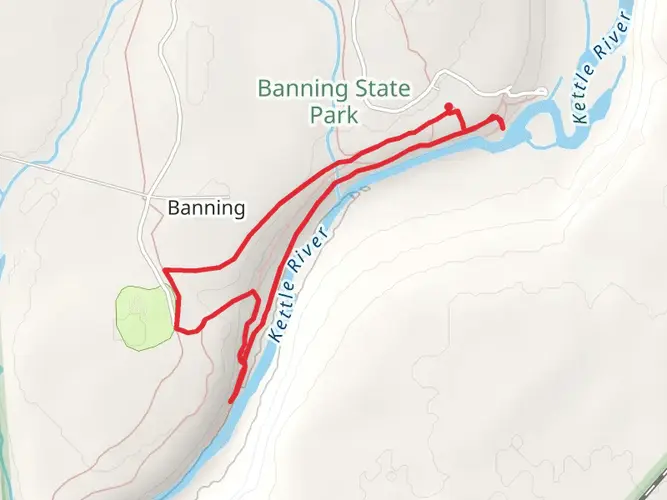
73.7 km
~3 days
158 m
Multi-Day
“Embark on the Gandy Dancer Trail for a historic walk through Wisconsin's picturesque wilderness and quaint towns.”
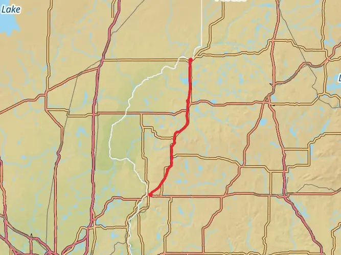
Spanning approximately 46 miles (74 kilometers) with a minimal elevation gain of around 328 feet (100 meters), the Gandy Dancer State Trail - North is a scenic journey through the serene landscapes of Burnett County, Wisconsin. This point-to-point trail is well-suited for hikers of all skill levels due to its easy rating and mostly flat terrain.
Getting to the Trailhead
The northern trailhead is located near the town of Danbury, Wisconsin. For those driving, you can start your journey at the intersection of Main Street and Peet Street in Danbury. If you're relying on public transportation, options may be limited, so it's advisable to check local transit resources for the latest schedules and routes that can get you close to the trailhead.
Trail Experience
As you embark on the Gandy Dancer State Trail, you'll be walking on a former railroad corridor, which is now a multi-use trail that accommodates hikers, cyclists, and in the winter, snowmobilers. The trail surface is primarily composed of crushed stone and gravel, making it accessible for most types of footwear and bicycles.
Historical Significance
The trail's name, "Gandy Dancer," is a nod to the early railroad workers who laid and maintained the tracks. These workers were known as "gandy dancers," and the trail pays homage to their contribution to the region's development. As you hike, imagine the rhythmic movements of the workers aligning tracks, a dance that was crucial to the railroad's operation.
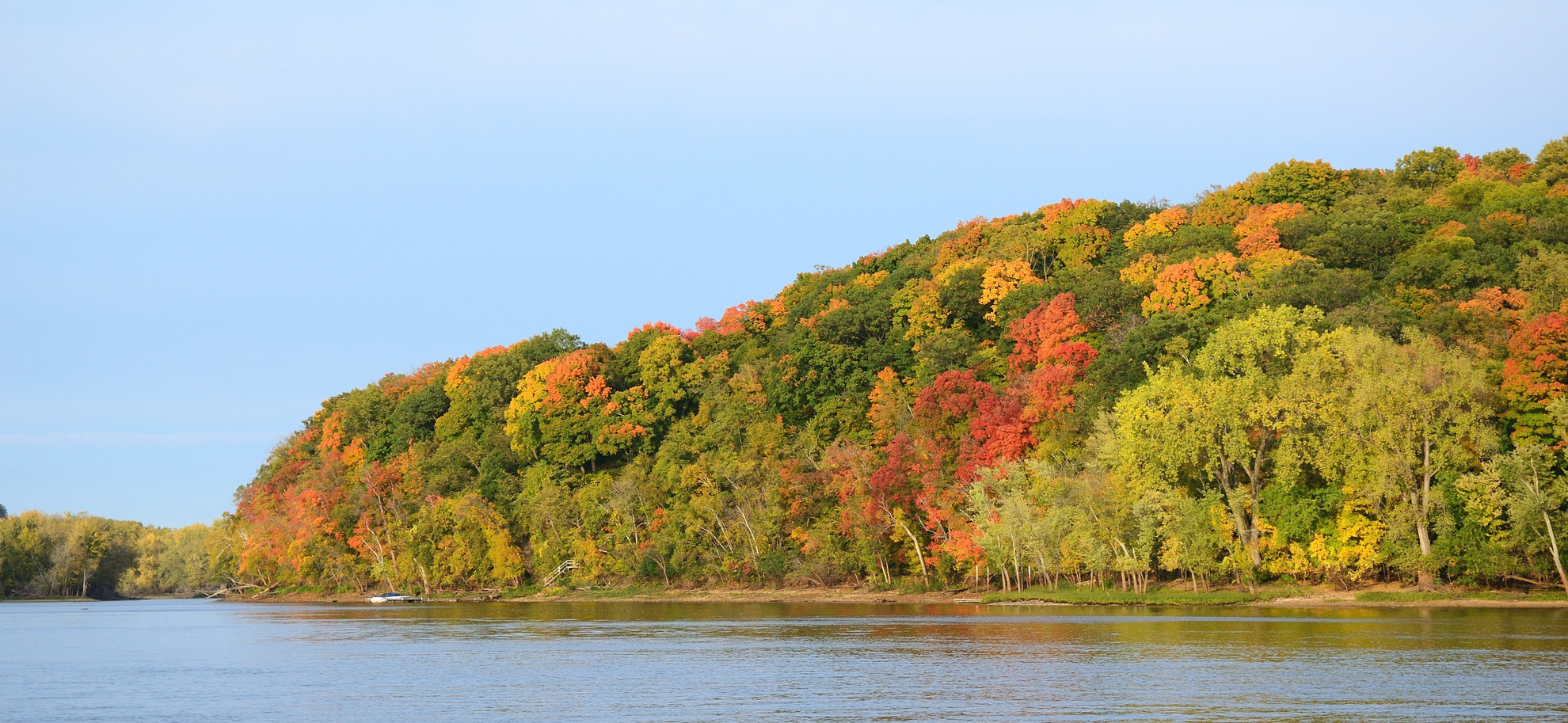
Natural Beauty and Wildlife
The trail offers a diverse array of landscapes, from wetlands and river crossings to dense forests and open farmland. Keep an eye out for the abundant wildlife in the area, including white-tailed deer, beavers, and a variety of bird species. The trail also passes through several small towns and communities, providing opportunities to rest and resupply.
Landmarks and Points of Interest
- St. Croix National Scenic Riverway: Early on, the trail intersects with this beautiful riverway, offering picturesque views and a chance to spot local wildlife.
- Yellow River Bridge: This historic bridge is a highlight for many, providing a scenic crossing over the Yellow River.
- Siren, WI: Roughly halfway through the trail, the village of Siren offers amenities and a chance to learn more about the local history.
- Webster, WI: As you approach the southern end of the trail, the town of Webster is another spot to rest and explore.
Navigation and Preparation
Before setting out, it's wise to download the trail map onto your HiiKER app to ensure you have offline access to navigation tools. The trail is well-marked, but having a digital map can help with planning your stops and overnight stays if you're doing a multi-day hike.
Seasonal Considerations
The Gandy Dancer State Trail is accessible year-round, but the experience can vary greatly depending on the season. Spring and fall offer cooler temperatures and vibrant foliage, while summer provides longer days and warmer weather. Winter transforms the trail into a snowy wonderland, popular among snowmobilers, so be prepared for colder conditions and the possibility of sharing the trail.
Trail Etiquette
As a multi-use trail, it's important to be mindful of others. Keep to the right, pass on the left, and announce your presence when overtaking others. If you're hiking with pets, keep them on a leash and always pack out what you pack in to preserve the natural beauty of the trail for future visitors.
Whether you're looking for a leisurely day hike or an extended adventure, the Gandy Dancer State Trail - North offers a unique glimpse into Wisconsin's natural landscapes and historical heritage.

Activity types
Frequently asked questions
How long is the Gandy Dancer State Trail - North and how many days does it take to hike?
The Gandy Dancer State Trail - North is 73.67 kilometers, or about 45.8 miles, long. With only 158 meters of elevation gain across the full route, it is usually approached as an easy multi-day hike, though strong walkers can also cover shorter out-and-back sections from Danbury.
Where do you start the Gandy Dancer State Trail - North in Wisconsin?
The Wisconsin end of the Gandy Dancer State Trail - North starts near Danbury in Burnett County, close to the Minnesota state line. Danbury is the key access town for the north section, and Burnett County notes that the broader Gandy Dancer corridor passes through Siren, Webster, and Danbury before reaching Minnesota.
Is the Gandy Dancer State Trail - North difficult for beginner hikers?
The Gandy Dancer State Trail - North is rated easy and climbs only 158 meters over 73.67 kilometers, so the grade stays very gentle for most of the route. It follows a former railroad corridor, which typically means long, straight stretches and a flatter profile than most backcountry trails.
What is the trail surface like on the Gandy Dancer State Trail - North?
The Gandy Dancer State Trail - North follows an old rail corridor and is generally surfaced with crushed stone and gravel. That makes it far smoother and less technical than a rocky footpath, but the long distance still calls for sturdy walking shoes, especially after rain or on looser sections.
Can dogs go on the Gandy Dancer State Trail - North?
Dogs are generally allowed on the Gandy Dancer State Trail, and the route is widely used as a dog-friendly rail trail. Because it is a multi-use corridor with hikers, cyclists, and seasonal motorized use, dogs should be kept under close control and checked against any posted local rules at access points near Danbury.
Is the Gandy Dancer State Trail - North open to snowmobiles or ATVs in winter?
Yes. The Gandy Dancer corridor is used for walking and biking in the warmer months, and Burnett County and Wisconsin trail guidance note winter use by snowmobiles and ATVs or UTVs when conditions allow. On Wisconsin-managed sections, winter motorized use typically depends on an officially opened trail and adequate snow base.
Do you need parking or town access for the Gandy Dancer State Trail - North near Danbury?
Danbury is the main access point for the Gandy Dancer State Trail - North and is the most practical place to begin a hike on the Wisconsin end. The trail is known for town-based access along the corridor, and Danbury serves as the northern Wisconsin gateway for parking, resupply, and shorter section hikes.
Comments and Reviews
User comments, reviews and discussions about the Gandy Dancer State Trail - North, Wisconsin.
4.63
average rating out of 5
8 rating(s)