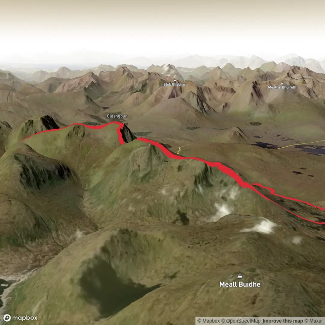
Tom na Pairce, Beinn a Chreachain, Meall Buidhe and Beinn Achaladair Loop from Loch Tulla
Download
3D Preview
Add to list
More
25.8 km
~7 hrs 9 min
1199 m
Loop
“A sweeping Highland circuit of grand ridges, wild exposure and hard-earned, far-reaching summit drama.”
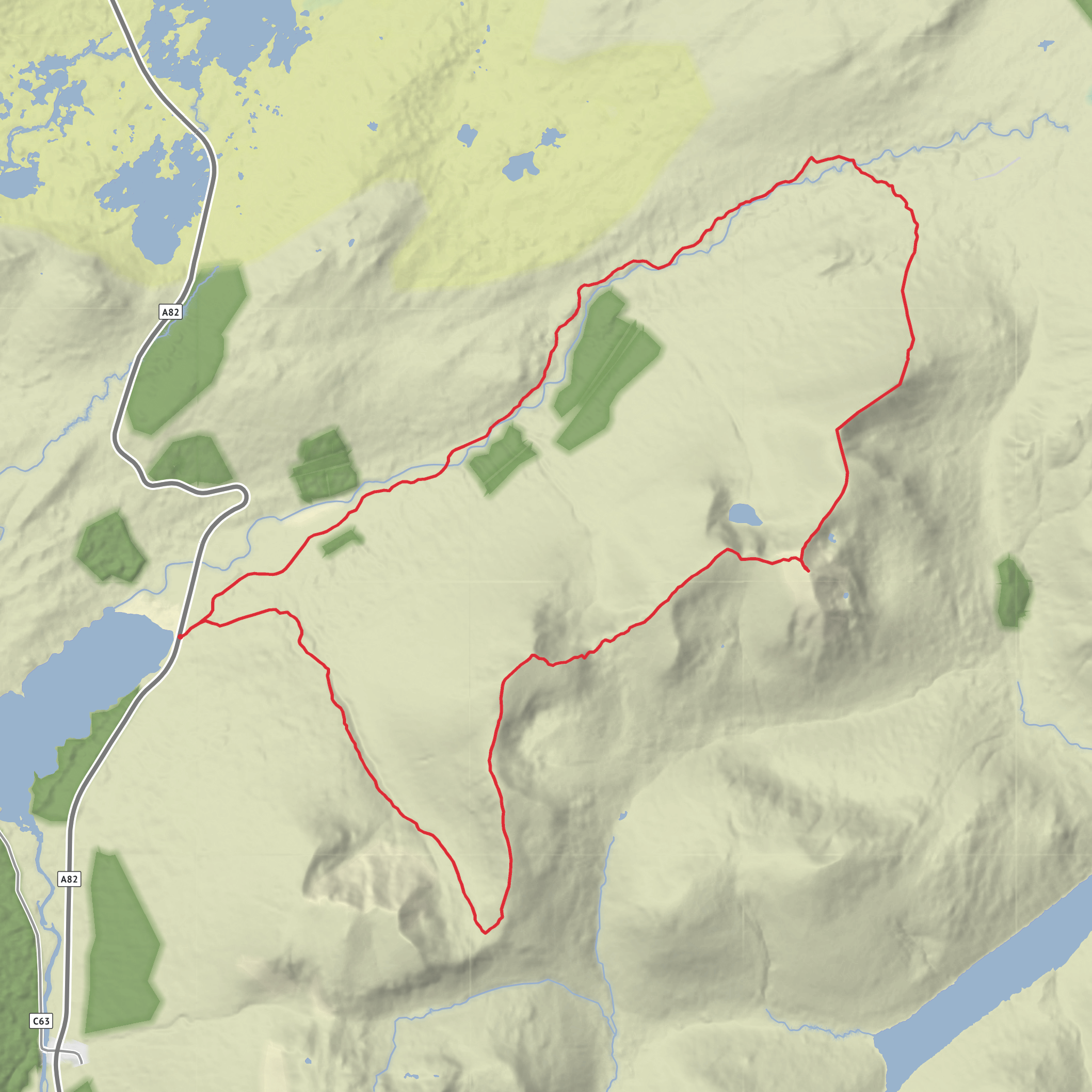
This 26 km (16.2 mile) circuit above Loch Tulla is a big Highland mountain day that links Tom na Pairce, Beinn a’ Chreachain, Meall Buidhe and Beinn Achaladair in one sweeping loop, with around 1,200 m (3,940 ft) of ascent. Although often rated medium for experienced hillwalkers, it feels much more serious than the label suggests: the day is long, the terrain is rough in places, and the route crosses broad, exposed mountain ground where wind, mist and wet underfoot can slow progress considerably. The start is near Achallader Farm and the walkers’ car park just off the A82 by Loch Tulla, close to Bridge of Orchy, Argyll and Bute, Scotland. (walkhighlands.co.uk)
The opening section is comparatively gentle. From the parking area, the route follows estate tracks and paths toward the Water of Tulla, with the mountains ahead rising beyond woodland and open moor. Early progress is usually quick, but this lower ground can be awkward after rain, especially around burns, boggy patches and riverside sections. If water levels are high, the crossing and approach lines can become more complicated, so this is a route where checking conditions beforehand and carrying a reliable offline route in HiiKER is especially useful. Tom na Pairce is more of a shoulder or intermediate high point than a dramatic summit, but it helps build the day gradually before the steeper pull onto Beinn a’ Chreachain. (walkhighlands.co.uk)
Climb to Beinn a’ Chreachain
The ascent steepens as the route gains the northeast ridge of Beinn a’ Chreachain. This mountain rises to about 1,081 m (3,547 ft) and is the highest point of the day. Its upper slopes are broad and grassy at first, then increasingly stony and open, with a fine sense of height developing over Loch Tulla, Rannoch Moor and the surrounding Munros. The summit itself is a notable viewpoint, and in clear weather the outlook is one of the strongest features of the whole loop. The mountain’s name is commonly translated as “Mountain of Scallops,” reflecting the area’s deep Gaelic place-name heritage. (en.wikipedia.org)
This part of the route demands steady pacing. From the start to Beinn a’ Chreachain, hikers cover roughly 9 to 10 km (5.6 to 6.2 miles) and gain most of the first major block of ascent. In poor visibility, the broad upper mountain can feel featureless, so careful bearing work may be needed. Cornices and snow build-up can also be a concern outside summer conditions, especially around steeper edges and corrie rims. (walkhighlands.co.uk)
Ridge to Meall Buidhe and Beinn Achaladair
From Beinn a’ Chreachain, the route continues back along the crest toward Meall Buidhe, a ridge summit of about 978 m (3,209 ft). This middle section is one of the most enjoyable parts of the day: a high connecting ridge with wide views and a strong sense of journeying across a mountain chain rather than simply climbing a single peak. The ground here is generally easier than the main ascent, though there are still uneven, rocky and sometimes boggy stretches. Some descriptions note a contouring path, but it is not always continuous, and many walkers simply stay on the ridge. (komoot.com)
After Meall Buidhe, the route drops to the bealach before the final climb to Beinn Achaladair, which reaches about 1,038 m (3,406 ft). This last ascent can feel tougher than expected because it comes late in the day, after a substantial amount of distance and elevation has already been covered. The east ridge gives a satisfying finish, and the summit is a particularly striking landmark above the A82 and the West Highland Line. Beinn Achaladair is well known for its prominence above this travel corridor, with both road and railway passing close to its lower slopes. (en.wikipedia.org)
From Beinn Achaladair, the descent returns toward the start by the broad ridge and lower tracks. This final leg is still long, and tired legs often make the lower rough ground feel slower than expected. Allow a full mountain day, commonly around 8 to 10 hours depending on pace, weather and stops. (stevenfallon.co.uk)
Terrain, hazards and what to prepare for
The route combines estate track, riverside approach, grassy ridges, stony summit ground and potentially wet moorland. Waterproof footwear is
Surfaces
Unknown
Unpaved
Dirt
Grass
Wood
Comments and Reviews
User comments, reviews and discussions about the Tom na Pairce, Beinn a Chreachain, Meall Buidhe and Beinn Achaladair Loop from Loch Tulla, Scotland.
average rating out of 5
0 rating(s)
