Download
3D Flyover
Add to list
More
45.2 km
~2 days
87 m
Multi-Day
“Embark on a scenic 45-kilometer journey along New Hampshire's historic rail trail, teeming with natural and cultural treasures.”
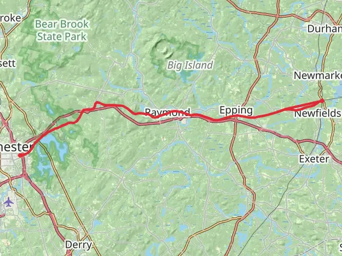
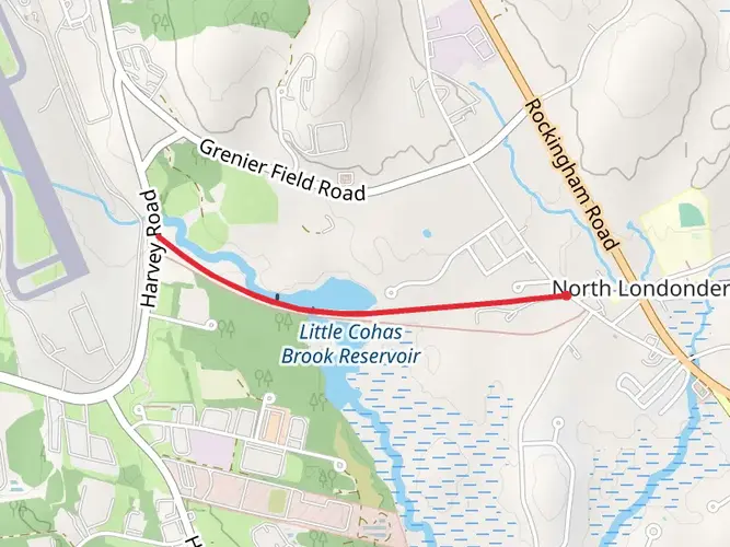
Spanning approximately 45 kilometers (28 miles) with negligible elevation gain, the Rockingham Recreational Rail Trail - Portsmouth Branch offers a unique journey through New Hampshire's scenic landscapes and historical sites. This point-to-point trail is accessible from the trailhead near Hillsborough County and stretches all the way to the coastal town of Portsmouth.
Getting to the Trailhead
To reach the starting point of the trail, you can drive to the vicinity of Mammoth Road and Lake Shore Road in Manchester, near the Massabesic Lake area. For those relying on public transportation, check local bus schedules as services may vary, and be prepared for a walk to reach the trailhead from the nearest bus stop.
Trail Experience
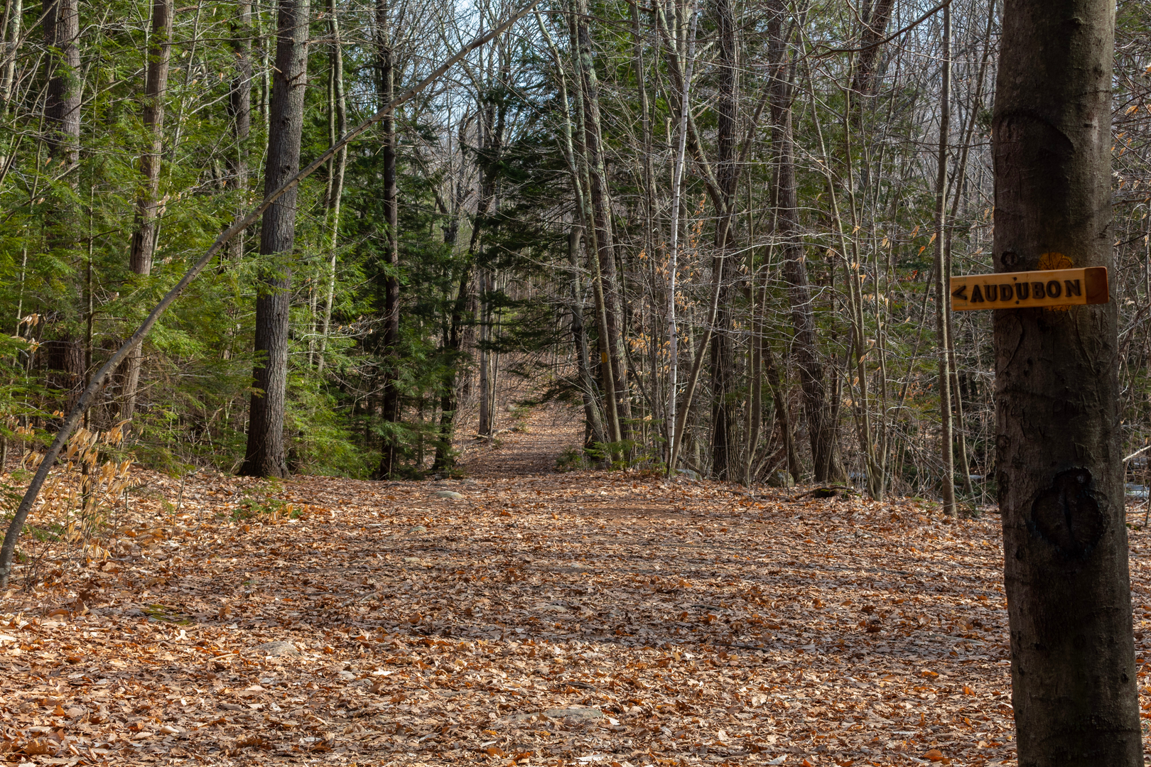
As you embark on the trail, you'll find yourself on a path that was once a bustling railroad line. The trail surface is a mix of gravel and packed dirt, suitable for both hikers and cyclists. The first section of the trail takes you through a mix of residential areas and wooded landscapes, offering glimpses of local wildlife such as deer, squirrels, and a variety of bird species.
Historical Significance
The trail follows the historic Portsmouth Branch of the Boston and Maine Railroad, which played a crucial role in the region's development. As you hike, you'll encounter remnants of the railway's past, including old signal posts and railway ties. The trail also passes through Raymond, where you can find a restored train depot that serves as a reminder of the area's rich transportation heritage.
Natural Landmarks
Approximately halfway through the trail, near the town of Epping, you'll cross the Lamprey River, a picturesque spot that's perfect for a rest and perhaps a picnic. The river is a vital ecosystem for local fish and plant life, and it's not uncommon to see anglers trying their luck.
Trail Amenities and Considerations
While the trail is rated medium difficulty due to its length, the flat terrain makes it accessible for most fitness levels. However, it's important to carry sufficient water and snacks, as there are limited facilities along the route. Seasonal weather conditions can also affect the trail's accessibility, so it's wise to check the forecast and prepare accordingly.
For navigation, HiiKER is an excellent tool to help you stay on track and be aware of upcoming points of interest. It's also a good idea to download the trail map on HiiKER before you go, as cell service can be spotty in some areas.
Approaching Portsmouth
As you near Portsmouth, the trail becomes more urban, and you'll start to see the Piscataqua River, which signifies the trail's end. Portsmouth is a historic seaport with a vibrant downtown area, offering a great opportunity to explore local shops, restaurants, and historical sites before arranging your return trip.
Whether you're interested in the natural beauty of New Hampshire, its wildlife, or the historical significance of the old railroad, the Rockingham Recreational Rail Trail - Portsmouth Branch provides a diverse and enriching outdoor experience.

What to expect?
Activity types
Frequently asked questions
How long is the Rockingham Recreational Rail Trail - Portsmouth Branch and how much climbing does it have?
The Rockingham Recreational Rail Trail - Portsmouth Branch is 45.25 kilometers, or about 28.1 miles, end to end. It gains only 87 meters, roughly 285 feet, across the full route, so it is a notably flat rail-trail outing and fits an easy rating rather than a steep backcountry hike.
Where does the Rockingham Recreational Rail Trail - Portsmouth Branch start and finish?
The Rockingham Recreational Rail Trail - Portsmouth Branch runs west to east from the Manchester area near Tarrytown Road, Mammoth Road, Lake Shore Road, and Massabesic Lake to the Newfields side of Rockingham Junction. Along the way it passes through communities including Raymond and Epping on its route across southern New Hampshire.
What is the trail surface like on the Rockingham Recreational Rail Trail - Portsmouth Branch?
Most of the Rockingham Recreational Rail Trail - Portsmouth Branch follows a former railroad grade, so the route stays broad and relatively gentle. The surface is generally gravel and packed dirt, with improved gravel in parts of Manchester near Lake Shore Road, making it suitable for walking, long-distance hiking, and biking as well as multi-day use.
Where can you park for the Rockingham Recreational Rail Trail - Portsmouth Branch?
Common access points for the Rockingham Recreational Rail Trail - Portsmouth Branch include the Manchester end near Massabesic Lake and Lake Shore Road, where trail users commonly park near Route 28, and the eastern end near the old depot area in Newfields by Rockingham Junction. Additional road crossings in towns such as Raymond and Epping also provide practical mid-route access.
Is the Rockingham Recreational Rail Trail - Portsmouth Branch good for beginners or kids?
The Rockingham Recreational Rail Trail - Portsmouth Branch is one of the more beginner-friendly long trails in southern New Hampshire because it is easy-rated, follows a rail corridor, and climbs only 87 meters over 45.25 kilometers. Short out-and-back sections from Manchester, Raymond, or Epping are usually more realistic for families than attempting the full point-to-point route.
Are dogs allowed on the Rockingham Recreational Rail Trail - Portsmouth Branch?
Dogs are commonly seen on the Rockingham Recreational Rail Trail - Portsmouth Branch, and the wide rail-trail corridor is generally well suited to leashed walks. Because the route crosses multiple towns and shared-use sections, keeping dogs leashed and under control is the safest approach, especially where cyclists, runners, and winter trail users may also be present.
Can you hike the Rockingham Recreational Rail Trail - Portsmouth Branch in winter?
The Rockingham Recreational Rail Trail - Portsmouth Branch can be used in winter, but conditions and permitted uses can change with snow cover. In New Hampshire, recreational rail trails may also serve as snowmobile corridors in season, and state trail condition notices have listed the Manchester-to-Newfields corridor separately, so winter users should expect shared use and possible temporary closures or changing surface conditions.
Comments and Reviews
User comments, reviews and discussions about the Rockingham Recreational Rail Trail - Portsmouth Branch, New Hampshire.
4.44
average rating out of 5
9 rating(s)