Download
3D Flyover
Add to list
More
104.1 km
~5 days
2296 m
Multi-Day
“The Border Route Trail: a historic, wildlife-rich trek through Minnesota's scenic Northwoods and rugged terrains.”
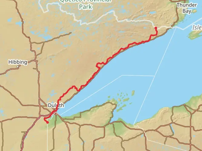
Nestled in the rugged wilderness of the Superior National Forest, the Border Route Trail offers an immersive experience through the heart of the Northwoods. Spanning approximately 104 kilometers (about 65 miles) with an elevation gain of around 2200 meters (approximately 7200 feet), this point-to-point trail is a journey through a landscape rich with natural beauty and historical significance.
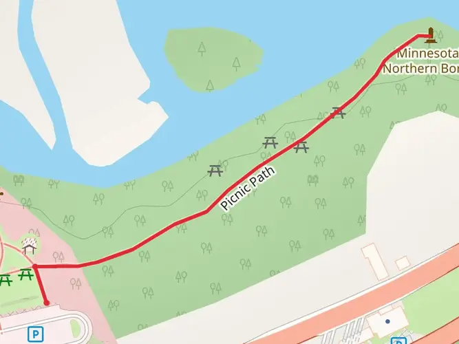
Getting to the Trailhead The trailhead is located near Cook County, Minnesota, and is accessible by car. For those starting at the western end, you can reach the trailhead by driving on Gunflint Trail (County Road 12) out of Grand Marais, following it until you reach the turnoff for the trail's western terminus. If you're approaching from the east, you'll find the eastern trailhead by taking Highway 61 to County Road 17 (Arrowhead Trail) and following it to the Otter Lake Road junction.
Navigating the Trail Hikers can rely on HiiKER to navigate the trail, ensuring they stay on the correct path through the dense forest and rugged terrain. The trail is marked, but due to the remote nature of the area, it's essential to have a reliable navigation tool.
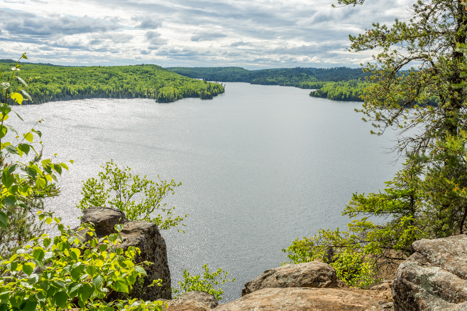
Landmarks and Scenery As you traverse the Border Route Trail, you'll encounter a variety of landscapes, from dense boreal forests to rocky cliffs offering panoramic views of the Boundary Waters Canoe Area Wilderness (BWCAW). The trail often follows ridgelines, providing hikers with stunning vistas of the surrounding lakes and wilderness.
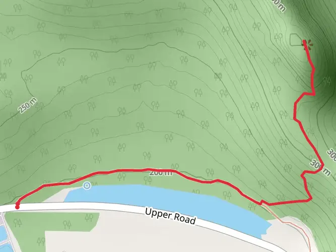
One of the most notable landmarks is the Rose Falls, a picturesque cascade that offers a serene spot for a break. Approximately 32 kilometers (20 miles) from the western trailhead, the falls are a highlight for many hikers.
Wildlife and Nature The area is teeming with wildlife, including moose, black bears, and a variety of bird species such as the common loon, whose haunting calls echo across the lakes. Hikers should be prepared for encounters with wildlife and know how to safely observe and respect these creatures from a distance.
Historical Significance The Border Route Trail runs along the international boundary between the United States and Canada, a region that was once a vital part of the fur trade route. As you hike, you're following in the footsteps of early voyageurs who navigated these lands by canoe, trading furs and goods with the indigenous peoples.
Trail Conditions and Preparation The trail is rated as medium difficulty, with some challenging sections that require good physical fitness. The terrain includes steep climbs, rocky outcrops, and occasional wet areas. Hikers should be prepared with appropriate footwear, clothing, and gear for variable conditions.
Seasonal Considerations The best time to hike the Border Route Trail is from late spring to early fall when the snow has melted, and the trails are more accessible. However, hikers should be aware of the potential for mosquitoes and blackflies during the warmer months and prepare accordingly.
Leave No Trace As with any wilderness trail, it's crucial to practice Leave No Trace principles. This means packing out all trash, being careful with campfires, and minimizing your impact on the environment to preserve the beauty and integrity of the trail for future hikers.
Conclusion The Border Route Trail is a journey through a historically rich and ecologically diverse landscape. With proper preparation and respect for the natural environment, hikers can enjoy a truly memorable experience in the heart of Minnesota's wilderness.

What to expect?
Activity types
Frequently asked questions
How long is the Border Route Trail in Minnesota and how many days does it usually take?
The Border Route Trail is about 104.05 km, or roughly 65 miles, across northeastern Cook County. Most backpackers split it into about 4 to 7 days, depending on pace, weather, and how much time is spent on the trail’s many ridgeline overlooks above the Boundary Waters Canoe Area Wilderness.
How hard is the Border Route Trail and is the terrain on the Border Route Trail very rugged?
The Border Route Trail is generally rated medium, but it is still a demanding multi-day route because it packs about 2,296 m of elevation gain into 104.05 km. The route is known for steep, rocky sections, frequent ups and downs, and remote stretches along high ridges near the Canadian border rather than long, flat cruising miles.
Where are the trailheads for the Border Route Trail and where do hikers usually park?
The Border Route Trail is commonly hiked point-to-point between a western access off the Gunflint Trail and an eastern access near Otter Lake Road in Cook County. Parking is typically arranged at the trailheads or nearby Forest Service access points, but vehicle logistics matter because the two ends are far apart on remote roads in Superior National Forest.
Are dogs allowed on the Border Route Trail in Minnesota?
Dogs are allowed on the Border Route Trail, but they must be kept on a leash on Superior National Forest hiking trails. That matters on this route because it passes through remote wildlife habitat in the Boundary Waters region, where loose dogs can create problems for wildlife, other hikers, and the dog itself.
Does the Border Route Trail require a permit for hiking or camping?
The Border Route Trail runs through the Boundary Waters Canoe Area Wilderness, so trip rules are stricter than on many front-country trails. Day hiking on the trail itself does not generally require a quota-style overnight paddle permit, but wilderness regulations apply, and overnight users should check current BWCAW rules before starting because access points and camping rules can affect trip planning.
What are the views and landmarks like on the Border Route Trail?
The Border Route Trail is best known for long ridge walks and big overlooks above the Boundary Waters Canoe Area Wilderness along the Minnesota-Ontario border. Hikers can expect repeated views over forest, cliffs, and lakes rather than a single summit objective, with the route also linking into the Kekekabic Trail and the Superior Hiking Trail as part of the North Country National Scenic Trail.
When is the best time of year to hike the Border Route Trail in Cook County?
The main hiking season for the Border Route Trail is late spring through fall, when snow is off the ridges and access roads are more reliable. Summer brings the longest daylight for a 104 km trip, while early fall often offers cooler temperatures and fewer insects, though conditions can still be rough and some sections may have downed trees or obscured tread.
Comments and Reviews
User comments, reviews and discussions about the Border Route Trail, Minnesota.
4.55
average rating out of 5
11 rating(s)