Download
Preview
Add to list
More
324.5 km
~22 days
12444 m
Multi-Day
“Embark on a breathtaking trek through Germany's Alpine splendor, brimming with natural and historical wonders.”
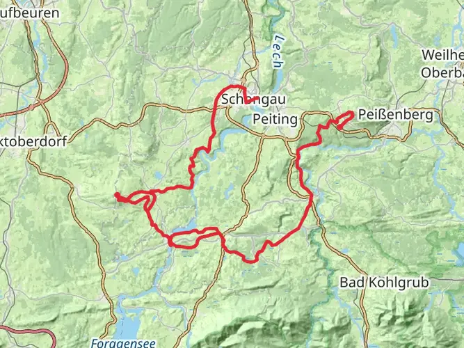
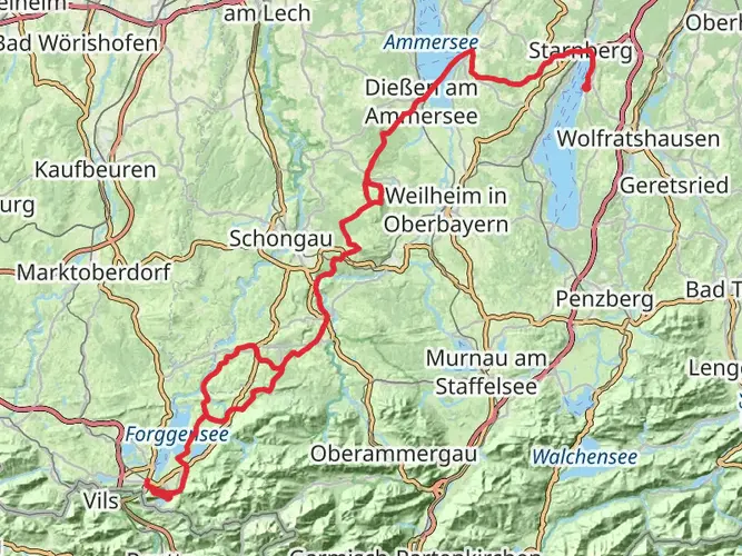
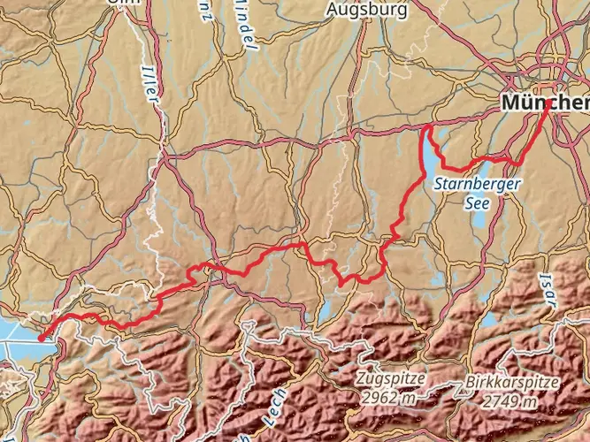
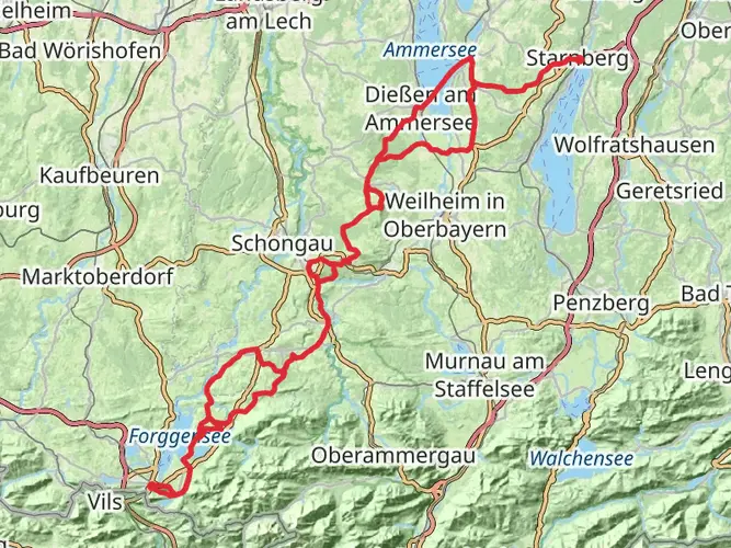
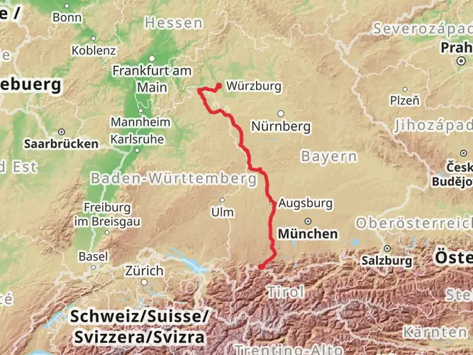
Embarking on the Himmelsstürmer-Route, hikers will traverse approximately 325 kilometers (202 miles) of varied terrain, with an elevation gain of around 12,400 meters (40,682 feet). This point-to-point trail, situated near Ostallgäu in Germany, is a challenging adventure that weaves through the majestic Alps, offering breathtaking vistas and a rigorous test of endurance.
Getting to the Trailhead
The journey begins near Ostallgäu, accessible by car or public transport. For those driving, the nearest significant landmark is Neuschwanstein Castle, a fairytale-like edifice that is a short drive from the trailhead. Public transport users can take a train to Füssen, followed by a bus towards the castle, alighting at a stop close to the trail's commencement.
Navigating the Trail
As you set out, ensure you have the HiiKER app downloaded for up-to-date trail maps and navigation. The route is well-marked, but having a digital tool can provide peace of mind and additional information about the trail as you progress.
Landmarks and Natural Beauty
The Himmelsstürmer-Route is a tapestry of alpine scenery, with lush meadows, crystal-clear lakes, and towering peaks. Early in the hike, the trail offers views of the iconic Neuschwanstein Castle, a 19th-century palace that embodies the romance of the region.
As you ascend, the Allgäuer Alps reveal themselves, with the trail winding through the Tannheimer Tal, a valley known for its alpine beauty. Approximately 100 kilometers (62 miles) in, you'll reach the highest point of the trail, offering panoramic views that are a reward for the strenuous climb.
Flora and Fauna
The region is rich in biodiversity. Hikers can expect to see a variety of alpine plants, including edelweiss, the iconic flower of the Alps. Wildlife is abundant, with chances to spot chamois, marmots, and golden eagles. Be sure to keep a respectful distance from any animals encountered along the way.
Historical Significance
The trail passes through areas steeped in history. The Alps have been a crossroads of cultures for centuries, and the Himmelsstürmer-Route is no exception. Hikers will pass through ancient trade routes and witness remnants of World War I fortifications, a somber reminder of the past.
Preparation and Planning
Given the trail's difficulty, hikers should be well-prepared with appropriate gear, including sturdy boots, weather-appropriate clothing, and sufficient food and water supplies. The route is dotted with huts and inns, but reservations are recommended, especially in the high season.
Safety and Etiquette
Safety is paramount on the Himmelsstürmer-Route. Be prepared for sudden weather changes and carry a first-aid kit. Always stay on marked trails to protect the fragile alpine environment and minimize the risk of getting lost.
Conclusion
The Himmelsstürmer-Route is a challenging yet rewarding journey through one of Europe's most stunning landscapes. With careful preparation and respect for the natural environment, hikers will find this trail to be an unforgettable experience.

Frequently asked questions
How long is the Himmelsstürmer-Route and how hard is it to hike?
The Himmelsstürmer-Route is 324.51 km long with 12,444 m of total ascent, so it is a true long-distance alpine trek rather than a short hut walk. It is graded Extra Difficult, which fits the scale of the elevation gain and the sustained mountain terrain across the Allgäu section of the route.
How many days does the Himmelsstürmer-Route usually take to complete?
A full thru-hike normally takes well over a week, and many hikers split a route of 324.51 km into roughly 2 to 3 weeks depending on stage length, weather, and accommodation plans. With 12,444 m of climbing, daily effort is often driven as much by elevation as by mileage.
Where does the Himmelsstürmer-Route start near Füssen and Neuschwanstein?
The route is commonly associated with the Schwangau and Füssen area, close to Neuschwanstein Castle in Ostallgäu. Füssen is the main rail hub for access, and Neuschwanstein sits near Schwangau, making that castle area one of the best-known gateways into this part of the Himmelsstürmer-Route.
Can you reach the Himmelsstürmer-Route by public transport from Füssen?
Yes. Füssen is the key public transport access point for this part of the route, and buses run onward toward the Neuschwanstein and Hohenschwangau area in Schwangau. That makes it practical to begin or join the Himmelsstürmer-Route without a car if approaching from the Füssen station area.
Is the Himmelsstürmer-Route part of the Wandertrilogie Allgäu?
Yes. The Himmelsstürmer-Route is one of the three long-distance routes in the Wandertrilogie Allgäu, alongside the Wiesengänger and Wasserläufer routes. Within that trilogy, the Himmelsstürmer line is the more alpine and demanding option, which matches its Extra Difficult rating and major elevation gain.
What is the difference between the Himmelsstürmer-Route and the Wasserläufer Route in Allgäu?
The main difference is terrain and effort. The Himmelsstürmer-Route is the mountain-focused line of the Wandertrilogie Allgäu, with 324.51 km and 12,444 m of ascent, while the Wasserläufer Route is the less alpine route in the same network and is generally aimed at hikers looking for a less summit-heavy experience.
Comments and Reviews
User comments, reviews and discussions about the Himmelsstürmer-Route, Germany.
5.0
average rating out of 5
5 rating(s)