Download
3D Flyover
Add to list
More
80.1 km
~3 days
450 m
Multi-Day
“Discover the Airline State Park Trail, a historical and scenic 50-mile adventure for hikers and cyclists.”
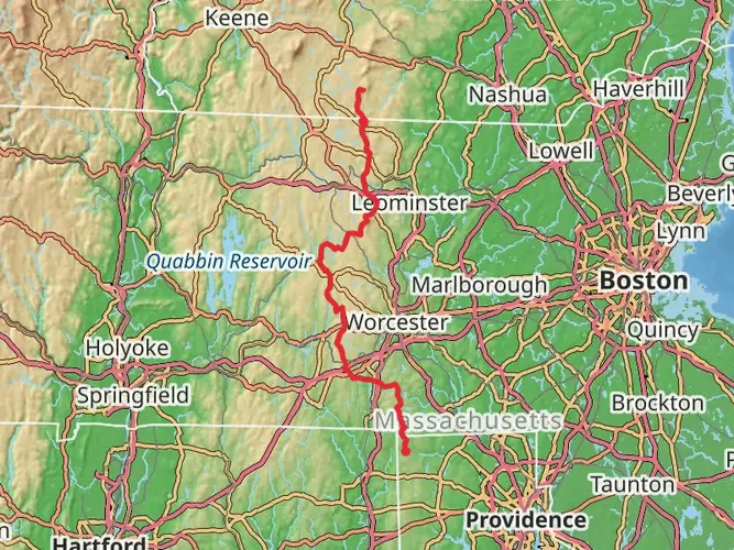
The Airline State Park Trail stretches approximately 80 kilometers (50 miles) across scenic Connecticut landscapes, with an elevation gain of around 400 meters (1,312 feet). This point-to-point trail, rated as medium difficulty, offers a unique blend of natural beauty and historical significance, making it a rewarding experience for hikers and cyclists alike.
Getting to the Trailhead
Located near Windham County, the trailhead can be accessed by car or public transportation. For those driving, parking is available at the start of the trail near East Hampton, which is the southern terminus. Public transport users can take a bus to nearby towns and then a short taxi ride to the trailhead.
The Journey Begins
Setting out from the southern end of the trail, hikers will find themselves on a path that was once part of the Air Line Railroad, which dates back to the late 1800s. The trail's name, "Airline," refers to the "air line" route that the railroad took – the shortest, most direct route rather than the easiest terrain.
Historical Significance and Natural Beauty
As you traverse the trail, you'll encounter remnants of the railroad's history, including old bridges and causeways that stand as a testament to the engineering feats of the era. The path is well-maintained, with crushed stone and some paved sections, making it accessible for both hikers and bikers.
Wildlife and Flora
The trail is enveloped by a mix of dense forests and wetlands, providing a habitat for a diverse array of wildlife. Keep an eye out for deer, beavers, and numerous bird species, including hawks and songbirds. The changing seasons bring a kaleidoscope of colors, from the lush greens of summer to the fiery hues of autumn.
Notable Landmarks
Around the 32-kilometer (20-mile) mark, you'll reach the impressive Lyman Viaduct, an iron trestle bridge that once carried trains over the deep ravine. Further along, the Rapallo Viaduct is another highlight, offering panoramic views of the surrounding landscape.
Elevation and Terrain
The trail's elevation gain is gradual, with the highest point around the halfway mark. The terrain is mostly flat or gently rolling, making it suitable for hikers of moderate fitness levels.
Preparing for the Hike
Before embarking on the Airline State Park Trail, it's advisable to download the trail map using the HiiKER app, which will assist with navigation and provide detailed information on the trail's features. Ensure you have adequate water and snacks, as there are limited facilities along the route. Dress in layers to accommodate the changing temperatures, and consider bringing a camera to capture the picturesque views.
Conclusion
By the time you reach the northern terminus of the trail, you will have experienced a journey through Connecticut's natural landscapes and its rich railroad history. The Airline State Park Trail offers a unique opportunity to explore the beauty of New England while walking along a path steeped in the past.

What to expect?
Activity types
Frequently asked questions
How long is the Airline State Park Trail - Connecticut and how many days does it take to finish?
The Airline State Park Trail - Connecticut is about 80.15 kilometers long, or just under 50 miles. With only around 450 meters of total elevation gain and an easy overall rating, many hikers split it into two to four days, while strong walkers and cyclists sometimes cover long sections in a single day.
Where can you park for the Airline State Park Trail - Connecticut?
The Airline State Park Trail - Connecticut has multiple access points and parking areas along its length rather than one single trailhead. Common access points include Smith Street in East Hampton, Village Hill Road in Lebanon, and East Thompson Road near the northern end in Thompson, which makes it practical for section hikes and point-to-point planning.
Is the Airline State Park Trail - Connecticut good for beginner hikers?
Yes. The Airline State Park Trail - Connecticut is generally considered an easy rail trail with a gentle grade, which reflects its railroad history. Over roughly 80.15 kilometers, the elevation gain is only about 450 meters, so the route is far less steep than a typical mountain hike and works well for beginners building up distance.
What is the surface like on the Airline State Park Trail - Connecticut?
The Airline State Park Trail - Connecticut follows a former rail corridor, so the tread is mostly wide and relatively even compared with backcountry footpaths. Sections include crushed stone, gravel, and some improved surfaces, with bridges and old railroad features along the route through towns such as East Hampton, Colchester, Hebron, Lebanon, Windham, Chaplin, Hampton, Pomfret, and Thompson.
Can dogs go on the Airline State Park Trail - Connecticut?
Dogs are generally allowed on the Airline State Park Trail - Connecticut as part of Connecticut's multi-use state park trail system, but they should be kept under control and cleaned up after. Because the trail is also used by walkers, cyclists, and in some sections horseback riders, a leash is the safest and most practical approach.
What towns does the Airline State Park Trail - Connecticut pass through?
The Airline State Park Trail - Connecticut runs across eastern Connecticut through a long chain of communities. Depending on the section, it passes through or links areas in East Hampton, Colchester, Hebron, Lebanon, Columbia, Windham, Chaplin, Hampton, Pomfret, and Thompson, which is one reason it works so well for shorter out-and-back hikes.
Is the Airline State Park Trail - Connecticut a loop or a point-to-point trail?
The Airline State Park Trail - Connecticut is a point-to-point route, not a loop. That matters on an 80.15-kilometer trail, because finishing the full length usually requires a car shuttle, pickup plan, or a turnaround strategy for hiking only one section.
Comments and Reviews
User comments, reviews and discussions about the Airline State Park Trail - Connecticut, Connecticut.
4.49
average rating out of 5
1711 rating(s)