10.1 km
~2 hrs 25 min
241 m
“Explore the Wenholthausen Rundweg's 10 km of natural beauty, historical landmarks, and vibrant wildlife.”
Starting near Hochsauerlandkreis, Germany, the Wenholthausen Rundweg is a picturesque loop trail that spans approximately 10 kilometers (6.2 miles) with an elevation gain of around 200 meters (656 feet). This medium-difficulty trail offers a delightful mix of natural beauty, historical landmarks, and opportunities for wildlife spotting.
### Getting There To reach the trailhead, you can either drive or use public transport. If driving, set your GPS to Wenholthausen, a charming village in the Hochsauerlandkreis district. There are parking facilities available near the village center. For those using public transport, take a train to Meschede and then a bus to Wenholthausen. The bus stop is conveniently located near the trailhead.
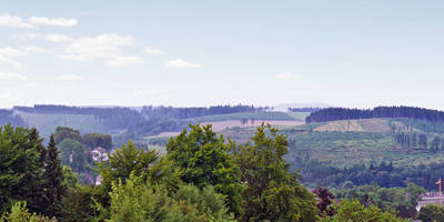
### Trail Overview The trail begins in the heart of Wenholthausen, a village known for its traditional half-timbered houses and serene atmosphere. As you start your hike, you'll be greeted by rolling hills and lush forests, characteristic of the Sauerland region. The initial part of the trail is relatively flat, making it a good warm-up before you encounter more challenging sections.
### Key Landmarks and Points of Interest - Wenholthausen Village: The trailhead itself is a point of interest. Take a moment to explore the village, which offers a glimpse into traditional German architecture and rural life. - Hiking through Forests: About 2 kilometers (1.2 miles) into the hike, you'll enter a dense forest area. The canopy provides ample shade, making it a pleasant walk even on warmer days. Keep an eye out for local wildlife such as deer and various bird species. - Scenic Overlook: At approximately the 5-kilometer (3.1 miles) mark, you'll reach a scenic overlook. This spot offers panoramic views of the surrounding valleys and hills. It's an excellent place to take a break and enjoy the scenery. - Historical Sites: Around the 7-kilometer (4.3 miles) point, you'll come across remnants of old farmhouses and possibly even ancient boundary stones. These landmarks offer a glimpse into the region's agricultural past.
### Elevation and Terrain The trail features a mix of terrains, including forest paths, open meadows, and gravel roads. The elevation gain is gradual, with the steepest sections occurring around the 4-kilometer (2.5 miles) and 8-kilometer (5 miles) marks. These sections can be a bit challenging but are manageable for most hikers with a moderate level of fitness.
### Navigation and Safety For navigation, it's highly recommended to use the HiiKER app, which provides detailed maps and real-time updates. The trail is well-marked, but having a reliable navigation tool ensures you stay on track. Always carry enough water, especially during the summer months, and wear appropriate footwear as some sections can be slippery after rain.
### Flora and Fauna The Wenholthausen Rundweg is rich in biodiversity. In spring and summer, the meadows are adorned with wildflowers, while the forests are home to a variety of trees, including oak, beech, and pine. Wildlife enthusiasts may spot deer, foxes, and a variety of bird species, making it a rewarding experience for nature lovers.
### Historical Significance The region around Wenholthausen has a rich history dating back to medieval times. The old farmhouses and boundary stones you encounter along the trail are remnants of this past. These historical markers offer a fascinating insight into the agricultural and social history of the Sauerland region.
This trail offers a balanced mix of natural beauty, moderate physical challenge, and historical intrigue, making it a rewarding experience for hikers of all levels.
Reviews
User comments, reviews and discussions about the Wenholthausen Rundweg, Germany.
0.0
average rating out of 5
0 rating(s)


