7.5 km
~1 hrs 55 min
252 m
“Explore the scenic, historical, and charming Golddorf Route Wenholthausen, an 8 km loop in Germany's Sauerland.”
Starting near the picturesque village of Wenholthausen in the Hochsauerlandkreis region of Germany, the Golddorf Route Wenholthausen is an 8 km (approximately 5 miles) loop trail with an elevation gain of around 200 meters (656 feet). This medium-difficulty trail offers a delightful mix of natural beauty, historical landmarks, and charming rural landscapes.
### Getting There To reach the trailhead, you can drive to Wenholthausen, which is well-connected by regional roads. If you prefer public transport, take a train to Meschede and then a bus to Wenholthausen. The nearest significant landmark to the trailhead is the St. Cäcilia Church in Wenholthausen, a beautiful example of local architecture.
### Trail Highlights
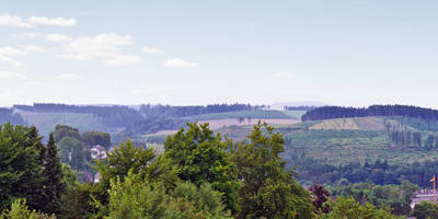
#### Scenic Views and Natural Beauty The trail meanders through lush forests, open meadows, and rolling hills, offering hikers a variety of scenic views. Early in the hike, you'll ascend gently through a mixed forest, where you might spot local wildlife such as deer and various bird species. The forest gives way to open fields around the 2 km (1.2 miles) mark, providing panoramic views of the surrounding Sauerland region.
#### Historical Significance Around the 4 km (2.5 miles) point, you'll come across the historic Wenholthausen Chapel, a small but significant landmark that dates back several centuries. This chapel is a testament to the region's rich cultural and religious history. Take a moment to appreciate the architecture and the serene surroundings before continuing your hike.
### Navigation and Waypoints The trail is well-marked, but it's always a good idea to have a reliable navigation tool. HiiKER is an excellent app for this purpose, offering detailed maps and real-time GPS tracking to ensure you stay on course.
#### Flora and Fauna As you continue, you'll pass through areas rich in diverse flora. Depending on the season, you might see wildflowers, ferns, and various types of trees, including oak and beech. The trail also crosses a small stream around the 6 km (3.7 miles) mark, where you can take a short break and enjoy the tranquil sounds of flowing water.
### Final Stretch The last 2 km (1.2 miles) of the trail bring you back towards Wenholthausen, descending gently through more open fields and offering a final set of stunning views. As you approach the village, you'll pass by traditional half-timbered houses, giving you a glimpse into the local way of life.
### Practical Information The trail is accessible year-round, but the best times to hike are during spring and autumn when the weather is mild, and the landscape is particularly vibrant. Wear sturdy hiking boots, bring plenty of water, and consider packing a light snack or picnic to enjoy along the way.
Public restrooms and dining options are available in Wenholthausen, making it convenient to freshen up and grab a meal after your hike.
Reviews
User comments, reviews and discussions about the Golddorf Route Wenholthausen, Germany.
0.0
average rating out of 5
0 rating(s)


