Mount Peale Trail
8.2 km
~3 hrs 1 min
837 m
“Embark on the invigorating 8 km Mount Peale Trail for stunning views and rich history in Utah's La Sal Mountains.”
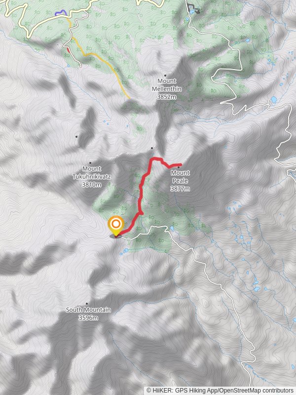
Starting your journey near San Juan County, Utah, the Mount Peale Trail offers an invigorating hike with a total distance of around 8 km (approximately 5 miles) and an elevation gain of about 800 meters (2,625 feet). This out-and-back trail is rated as medium difficulty, making it suitable for moderately experienced hikers.
### Getting There To reach the trailhead, you can drive or use public transportation. If driving, head towards the La Sal Mountains, specifically near the Geyser Pass Road. The nearest significant landmark is the Geyser Pass Trailhead, which is easily accessible by car. For those relying on public transport, the closest major town is Moab, Utah. From Moab, you can arrange a shuttle or taxi service to the Geyser Pass Trailhead.
### Trail Overview The trail begins at the Geyser Pass Trailhead, situated at an elevation of approximately 3,048 meters (10,000 feet). The initial section of the trail meanders through dense forests of aspen and pine, offering a cool and shaded start to your hike. As you progress, the trail gradually ascends, providing stunning views of the surrounding La Sal Mountains.
### Significant Landmarks and Nature Around the 2 km (1.2 miles) mark, you'll encounter a picturesque meadow, often dotted with wildflowers in the spring and summer months. This is a great spot to take a short break and enjoy the natural beauty. Continuing on, the trail becomes steeper and rockier, so be prepared for a more strenuous climb.
At approximately 4 km (2.5 miles) into the hike, you'll reach the saddle between Mount Peale and Mount Tukuhnikivatz. From here, the trail turns more rugged and exposed, with loose rocks and scree. This section requires careful footing and attention to the trail markers.
### Wildlife and Flora The Mount Peale Trail is home to a variety of wildlife, including mule deer, elk, and occasionally black bears. Birdwatchers will also delight in spotting species such as the Clark's Nutcracker and the Mountain Bluebird. The flora is equally diverse, with alpine wildflowers, subalpine firs, and Engelmann spruce populating the landscape.
### Historical Significance The La Sal Mountains have a rich history, with evidence of Native American habitation dating back thousands of years. The Ute and Navajo tribes have historically used these mountains for hunting and gathering. Additionally, the area was explored by early Spanish settlers and later by American pioneers.
### Final Ascent The final push to the summit of Mount Peale is the most challenging part of the hike. The last 1 km (0.6 miles) involves a steep climb with an elevation gain of about 200 meters (656 feet). Upon reaching the summit, you'll be rewarded with panoramic views of the La Sal Mountains, the Colorado Plateau, and even the distant Rocky Mountains on a clear day.
### Navigation For navigation, it's highly recommended to use HiiKER, which provides detailed maps and real-time GPS tracking to ensure you stay on the correct path.
Prepare adequately with water, snacks, and appropriate gear, and always check the weather conditions before setting out, as the high elevation can lead to sudden changes in weather.
Reviews
User comments, reviews and discussions about the Mount Peale Trail, Utah.
4.0
average rating out of 5
14 rating(s)


