12.8 km
~3 hrs 54 min
819 m
“The invigorating Red Pine Trail offers a moderately challenging 13 km hike with stunning alpine scenery and rich history.”
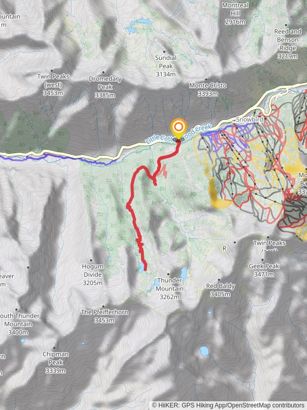
Starting near Salt Lake County, Utah, the Red Pine Trail is an invigorating out-and-back hike that spans approximately 13 kilometers (8 miles) with an elevation gain of around 800 meters (2,625 feet). This trail is rated as medium difficulty, making it suitable for moderately experienced hikers looking for a rewarding challenge.
### Getting There To reach the trailhead, you can drive or use public transportation. If driving, head towards the White Pine Trailhead parking lot, located off Little Cottonwood Canyon Road (UT-210). For those using public transport, the Utah Transit Authority (UTA) offers bus services that can drop you off near the trailhead. Check the UTA schedules for the most current routes and times.
### Trail Overview The Red Pine Trail begins at the White Pine Trailhead, which is well-marked and easy to locate. The initial section of the trail is relatively gentle, winding through a dense forest of aspen and pine trees. This part of the trail is a great opportunity to spot local wildlife such as mule deer and various bird species.
### Key Landmarks and Elevation At approximately 2 kilometers (1.2 miles) into the hike, you'll encounter a fork in the trail. Take the right path to continue on the Red Pine Trail. The left path leads to the White Pine Lake, another beautiful destination but not part of this hike. From this junction, the trail begins to ascend more steeply.
Around the 4-kilometer (2.5-mile) mark, you'll reach a picturesque meadow, offering a brief respite from the climb and stunning views of the surrounding peaks. This is a good spot to take a break and hydrate.
### Historical Significance The region around the Red Pine Trail has a rich history tied to the early settlers and mining activities in the 19th century. Little Cottonwood Canyon was a significant mining area, and remnants of old mining equipment can sometimes be spotted off the trail. The canyon was also a route for the Mormon pioneers who settled in the Salt Lake Valley.
### Final Ascent and Red Pine Lake The final 2 kilometers (1.2 miles) of the trail are the most challenging, with a steep ascent that will test your endurance. However, the effort is well worth it as you approach Red Pine Lake. Nestled at an elevation of approximately 3,000 meters (9,842 feet), the lake is a serene alpine gem surrounded by towering peaks and lush greenery.
### Navigation and Safety Given the elevation and potential for sudden weather changes, it's crucial to be prepared. Use the HiiKER app for real-time navigation and updates on trail conditions. Always carry sufficient water, snacks, and layers of clothing to adapt to changing weather.
### Wildlife and Flora The trail is home to diverse flora and fauna. In the lower sections, you'll find a mix of aspen groves and pine forests. As you ascend, the vegetation becomes sparser, giving way to alpine meadows filled with wildflowers during the summer months. Keep an eye out for marmots and pika in the higher elevations.
### Return Journey After enjoying the tranquility of Red Pine Lake, retrace your steps back to the trailhead. The descent offers a different perspective and is generally quicker, but still requires caution, especially on the steeper sections.
By planning ahead and using reliable navigation tools like HiiKER, you can ensure a safe and enjoyable hike on the Red Pine Trail.
Reviews
User comments, reviews and discussions about the Red Pine Trail, Utah.
0.0
average rating out of 5
0 rating(s)


