Download
3D Preview
Add to list
More
161.4 km
~6 days
1818 m
Multi-Day
“Embark on the historic Orle Gniazda Trail, a scenic and challenging trek dotted with medieval castles and diverse wildlife.”
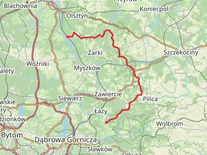
The Orle Gniazda Trail, also known as the Eagles' Nests Trail, is a captivating journey through the picturesque landscape of the Kraków-Częstochowa Upland in Poland. Spanning approximately 161 kilometers (100 miles) with an elevation gain of around 1800 meters (5905 feet), this point-to-point trail is a challenging yet rewarding experience for avid hikers.
Getting to the Trailhead
The trailhead is located near Częstochowa, a city well-known for the Jasna Góra Monastery, which is a significant religious and historical site. To reach the starting point, hikers can take public transport or drive to Częstochowa and then follow local roads towards the outskirts of the city where the trail begins.
Navigating the Trail
Hikers can rely on HiiKER for detailed maps and navigation tools to guide them along the Orle Gniazda Trail. The trail is marked, but due to its length and complexity, having a digital tool can be invaluable for staying on track.
Historical Significance
The trail derives its name from the series of medieval castles, known as the "Eagles' Nests," perched atop limestone cliffs along the route. These fortresses date back to the 14th century and were constructed under the reign of King Casimir III the Great. They were part of a defensive chain guarding the western border of the Polish Kingdom. Hikers will encounter these historical landmarks, including the well-preserved castles at Olsztyn, Bobolice, and Mirów.
Landmarks and Nature
As hikers embark on this journey, they will traverse through a variety of terrains including forests, limestone rock formations, and open meadows. The trail offers panoramic views of the surrounding landscape, with the most breathtaking vistas found at the highest points along the route.
One of the natural highlights is the Ojców National Park, which is home to an abundance of wildlife and unique rock formations such as the Hercules' Club. The park also features the picturesque ruins of Ojców Castle and the Kraków Gate rock arch.
Wildlife
The region is rich in biodiversity, with the possibility of encountering a variety of bird species, including eagles, which are emblematic of the trail's name. The forests and meadows are also home to deer, boars, and numerous small mammals and insects.
Preparation and Planning
Given the trail's difficulty rating and length, hikers should be well-prepared with appropriate gear, including sturdy hiking boots, weather-appropriate clothing, and sufficient water and food supplies. It's advisable to plan for multiple days of hiking to complete the trail, with stops at local guesthouses or designated camping areas.
Seasonal Considerations
The best time to hike the Orle Gniazda Trail is from late spring to early autumn when the weather is mild and the natural scenery is at its most vibrant. However, hikers should be prepared for sudden weather changes and carry rain gear and additional layers.
Safety and Etiquette
As with any long-distance hike, safety should be a priority. Hikers should inform someone of their plans and expected return, carry a first aid kit, and be aware of the terrain and weather conditions. It's also important to respect the natural environment by staying on marked trails, not disturbing wildlife, and carrying out all trash.
By following these guidelines and being prepared, hikers can fully enjoy the historical and natural wonders of the Orle Gniazda Trail.

Comments and Reviews
User comments, reviews and discussions about the Orle Gniazda Trail, Poland.
4.75
average rating out of 5
4 rating(s)