Download
3D Flyover
Add to list
More
484.9 km
~17 days
2251 m
Multi-Day
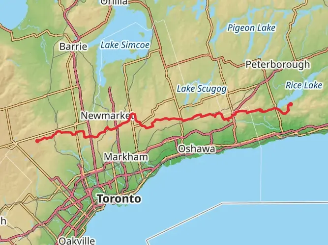
The Ganaraska Trail is a 484.9 km trail that starts in Port Hope, Port Hope, Ontario. Based on our data, the hike is graded as Medium. For information on how we grade trails, please read measuring the difficulty of a hiking trail on hiiker. Also, check our latest community posts for trail updates. This hike can be completed in approx 17 days. Caution is advised on trail times as this depends on multiple variables. For more info read about how we calculate hike time.

Frequently asked questions
How long is the Ganaraska Trail in Ontario?
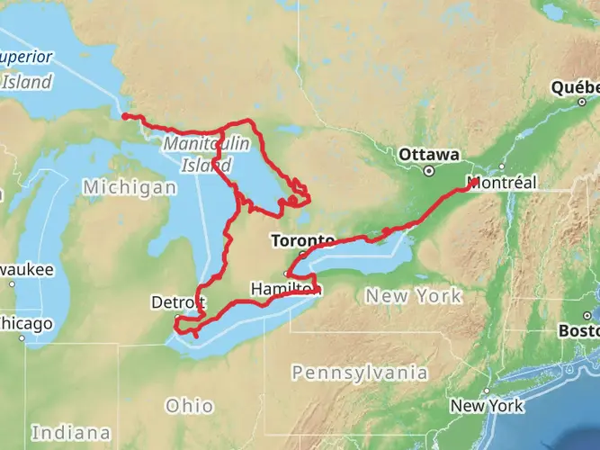
The Ganaraska Trail is about 484.92 km long, making it a true multi-day route rather than a single-day hike. The full trail runs from Port Hope on Lake Ontario north and west across central Ontario, with the main route reaching Glen Huron near the Niagara Escarpment.
How difficult is the Ganaraska Trail and how much climbing does the Ganaraska Trail have?
The Ganaraska Trail is generally rated medium difficulty, but the challenge comes from its length as much as its terrain. The route has about 2,251 m of total elevation gain spread over nearly 485 km, so most hikers tackle it in sections or as a longer end-to-end trip.
Where does the Ganaraska Trail start and finish?
The Ganaraska Trail begins in Port Hope, Ontario, at a boulder opposite the town hall near the mouth of the Ganaraska River and Lake Ontario. The main trail continues northwest to Glen Huron, where a cairn marks the end near the Bruce Trail, with additional branches continuing toward Wasaga Beach and the Midland area.
Can you camp on the Ganaraska Trail?
Camping is generally not allowed along the Ganaraska Trail. The main exception is the Wilderness section, where camping is permitted only at designated sites, so most end-to-end hikers plan on using towns, road access points, or off-trail accommodations between sections.
Are dogs allowed on the Ganaraska Trail?
Dogs are allowed on much of the Ganaraska Trail, but they need to be kept on leash near farms and anywhere required by law. Some stretches prohibit dogs because of livestock or landowner restrictions, and dogs are not permitted on organized group hikes run by the trail association.
How is the Ganaraska Trail marked?
The Ganaraska Trail is marked with white blazes on the main trail and blue blazes on side trails. In rougher backcountry areas, especially in the Wilderness section, hikers may also see rock cairns, flagging tape, painted rock markers, and double blazes or dog-leg markers showing changes in direction.
Is the Ganaraska Trail suitable for a first multi-day hike?
The Ganaraska Trail can work as a first multi-day route if it is broken into shorter sections instead of attempted end to end. Its medium rating, long distance, and mix of private land, forest, moraine terrain, and rugged backcountry mean the Wilderness section is better suited to experienced hikers familiar with remote trail travel.
Comments and Reviews
User comments, reviews and discussions about the Ganaraska Trail, Ontario.
4.89
average rating out of 5
9 rating(s)