Download
3D Preview
Add to list
More
31.4 km
~6 hrs 44 min
268 m
Multi-Day
“Embark on a scenic 19-mile hike through Michigan's lush forests, teeming with wildlife and rich history, on the Pine Marten Run Trail.”
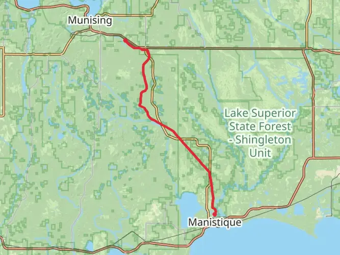
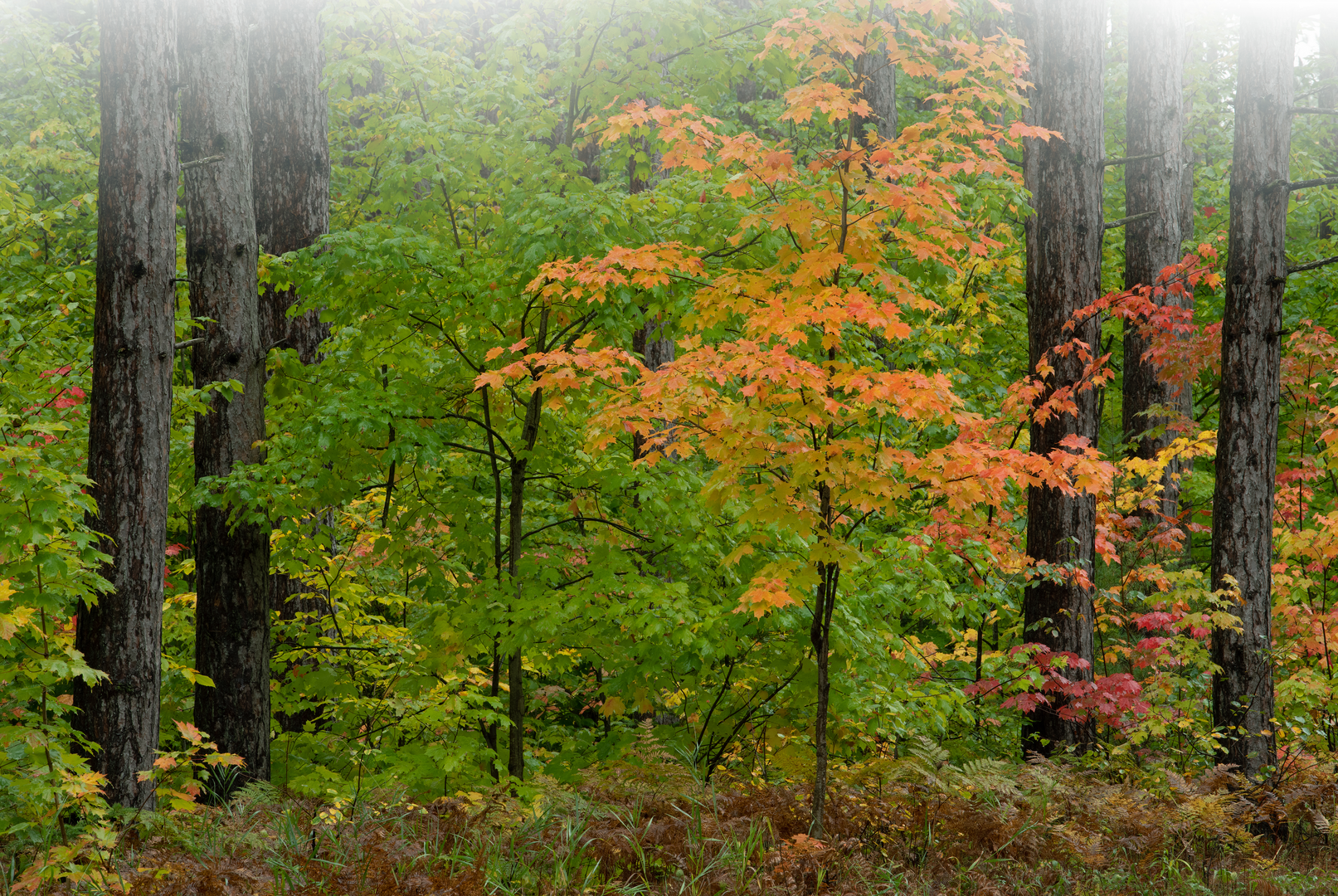
The Pine Marten Run Trail, nestled in the picturesque landscapes of Schoolcraft County, Michigan, offers an immersive experience into the heart of northern hardwood forests. Spanning approximately 31 kilometers (around 19 miles) with an elevation gain of roughly 200 meters (about 656 feet), this loop trail is a delightful challenge for those with a moderate level of hiking experience.
Getting to the Trailhead
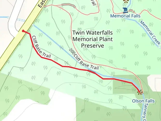
To reach the starting point of the Pine Marten Run Trail, hikers can drive to the vicinity of Schoolcraft County. The trailhead is accessible by taking M-28 to Forest Highway 13, then continuing to the Clear Lake Education Center, which serves as a significant landmark near the trail's commencement. For those relying on public transportation, options may be limited, and it's advisable to check local transit resources for the latest schedules and routes that can get you close to the area.
Navigating the Trail
As you embark on your journey, you'll find that the trail is well-marked, with clear signage to guide you along the way. For additional navigation support, the HiiKER app can be a valuable tool, offering detailed maps and GPS coordinates to ensure you stay on the right path.
Natural Beauty and Wildlife
The Pine Marten Run Trail meanders through a diverse ecosystem, where hikers can witness a variety of flora and fauna. The trail is named after the elusive pine marten, a small, agile member of the weasel family that inhabits the area. Keep an eye out for these creatures, along with white-tailed deer, red squirrels, and a myriad of bird species, including the pileated woodpecker and the northern goshawk.
Historical Significance
The region surrounding the trail is steeped in history, with ties to the early logging industry that once thrived in Michigan. As you hike, you'll encounter remnants of old logging camps and might spot the occasional rusted artifact, a silent testament to the area's past. The trail itself is a modern homage to the conservation efforts that have preserved these lands for future generations to enjoy.
Landmarks and Points of Interest
Approximately 10 kilometers (about 6 miles) into the hike, you'll reach a serene overlook offering expansive views of the surrounding forest canopy. This is an ideal spot to take a break and enjoy the natural beauty of the area. Further along, the trail crosses several small streams, where the gentle sound of flowing water complements the peaceful ambiance.
Preparation and Safety
Before setting out, ensure you're prepared with adequate water, snacks, and layers of clothing to adapt to changing weather conditions. The trail can be muddy in places, especially after rain, so waterproof hiking boots are recommended. Always let someone know your hiking plans and expected return time, and carry a charged mobile phone with the HiiKER app downloaded for safety and navigation.
By respecting the trail and its natural inhabitants, you'll help preserve the Pine Marten Run Trail for future adventurers to enjoy. Whether you're drawn by the allure of wildlife, the tranquility of the forest, or the echoes of history, this trail promises a rewarding experience for all who traverse its path.

What to expect?
Activity types
Frequently asked questions
How long is the Pine Marten Run Trail in Schoolcraft County, Michigan?
The Pine Marten Run Trail is 31.45 kilometers long, which is about 19.5 miles. That length puts it firmly in multi-day territory for most hikers, even though the overall elevation gain is a modest 268 meters. The route is generally considered easy rather than steep or highly technical.
How difficult is the Pine Marten Run Trail and is it good for beginner backpackers?
The Pine Marten Run Trail is rated easy, with 268 meters of elevation gain over 31.45 kilometers. That means the challenge comes more from the distance than from sustained climbing. It can suit beginner backpackers who are comfortable covering long mileage and spending a night out in a remote forest setting.
Is the Pine Marten Run Trail a loop trail or an out-and-back hike?
The Pine Marten Run Trail is commonly described as a trail system made up of interconnected loops in the Ironjaw Lake semi-primitive area of Hiawatha National Forest. The mapped hike length here is 31.45 kilometers, so route options can vary depending on which loop combination is chosen. That layout makes it easier to shorten or extend a trip than on a single out-and-back trail.
Where is the Pine Marten Run Trail trailhead and how do hikers get there?
The Pine Marten Run Trail is in Schoolcraft County in Hiawatha National Forest, northwest of Manistique. It is commonly reached from M-28 via Forest Highway 13, with the Clear Lake Education Center serving as a useful nearby landmark. Regional trail references also place the system between County Road 437 and Highway 13.
Can the Pine Marten Run Trail be done as an overnight backpacking trip?
Yes. At 31.45 kilometers, the Pine Marten Run Trail is long enough for a comfortable overnight trip, especially for hikers who want a relaxed pace. The trail system is also associated with backcountry-accessible campsites around Swan Lake in Hiawatha National Forest, which supports multi-day use in this area.
What kind of terrain and setting does the Pine Marten Run Trail have?
The Pine Marten Run Trail runs through the Ironjaw Lake semi-primitive area in Hiawatha National Forest. Hikers can expect a northern forest setting with multiple lakes and relatively gentle overall climbing, reflected in the 268-meter elevation gain across the full 31.45-kilometer route. The easy rating suggests the terrain is more rolling than mountainous.
When is the best time of year to hike the Pine Marten Run Trail?
The main hiking season is typically the snow-free period from spring through fall. Forest Service facility records for the Pine Marten Run West Trailhead list a seasonal operating window from about April 15 to December 1, which aligns with the most practical time to plan a trip. Conditions in Schoolcraft County can still be wet, buggy, or cold at the edges of that season.
Comments and Reviews
User comments, reviews and discussions about the Pine Marten Run Trail, Michigan.
4.5
average rating out of 5
6 rating(s)