10.5 km
~2 hrs 29 min
234 m
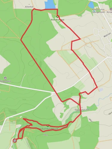
“The Hessenblick via Beilsteiner Weg is a scenic 11 km trail featuring castle ruins, panoramic views, and wildlife.”
Starting near Westerwaldkreis, Germany, the Hessenblick via Beilsteiner Weg is a scenic loop trail that spans approximately 11 kilometers (around 6.8 miles) with an elevation gain of about 200 meters (656 feet). This medium-difficulty trail offers a delightful mix of natural beauty, historical landmarks, and opportunities for wildlife observation.
### Getting There To reach the trailhead, you can drive or use public transport. If driving, set your GPS to the nearest known address: Westerwaldkreis, Germany. For those using public transport, take a train to Montabaur station, which is well-connected to major cities like Frankfurt and Cologne. From Montabaur, you can catch a local bus or taxi to the trailhead.
### Trail Overview The trail begins near Westerwaldkreis and quickly immerses you in the lush forests and rolling hills characteristic of the Westerwald region. The initial section is relatively flat, making it an excellent warm-up as you traverse through dense woodlands.
### Key Landmarks and Sections - Beilstein Castle Ruins (approx. 3 km / 1.9 miles in): One of the first significant landmarks you'll encounter is the Beilstein Castle ruins. This medieval structure offers a glimpse into the region's historical past. Take a moment to explore the ruins and enjoy panoramic views of the surrounding countryside. - Hessenblick Viewpoint (approx. 5 km / 3.1 miles in): As you continue, the trail gradually ascends to the Hessenblick viewpoint. This spot provides breathtaking vistas of the Hessen region, making it a perfect place for a rest and some photography. The elevation gain to this point is about 100 meters (328 feet).
- Westerwald Forest (approx. 7 km / 4.3 miles in): The trail then meanders through the Westerwald forest, a haven for nature enthusiasts. Keep an eye out for local wildlife such as deer, foxes, and a variety of bird species. The forest is also home to several types of flora, including oak, beech, and pine trees.
### Navigation and Safety The trail is well-marked, but it's always a good idea to have a reliable navigation tool. Use HiiKER to download the trail map and keep track of your progress. The app will also provide real-time updates and alerts, ensuring you stay on the right path.
### Historical Significance The Westerwald region has a rich history dating back to Roman times. The Beilstein Castle, built in the 12th century, is a testament to the area's medieval heritage. The trail itself has been used for centuries, serving as a route for traders and travelers.
### Final Stretch The last few kilometers of the trail are a gentle descent back to the starting point. This section offers a mix of open meadows and forested areas, providing a serene end to your hike. The total elevation gain for the entire loop is around 200 meters (656 feet), making it a manageable yet rewarding hike.
Whether you're a history buff, nature lover, or simply looking for a moderate hike with stunning views, the Hessenblick via Beilsteiner Weg offers something for everyone.
Reviews
User comments, reviews and discussions about the Hessenblick via Beilsteiner Weg, Germany.
5.0
average rating out of 5
4 rating(s)


