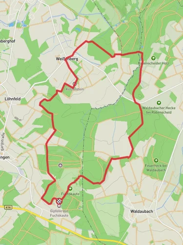
13.2 km
~2 hrs 48 min
93 m
“Explore Westerwald's scenic 13 km trail, featuring panoramic views, historical landmarks, and abundant wildlife.”
Starting near Westerwaldkreis, Germany, this 13 km (approximately 8 miles) point-to-point trail offers a medium difficulty hike with no significant elevation gain, making it accessible for a wide range of hikers. The trailhead is conveniently located near the town of Rennerod, which can be reached by car or public transport. If you're driving, there are parking facilities available in Rennerod. For those using public transport, Rennerod is serviced by regional buses from larger cities like Limburg and Siegen.
### Trail Overview
The trail begins at the base of the Fuchskaute, the highest peak in the Westerwald region, standing at 657 meters (2,156 feet). Although the trail itself does not involve significant elevation changes, the surrounding landscape offers panoramic views of the Westerwald's rolling hills and dense forests. The Fuchskaute area is known for its unique geological formations and diverse flora, including rare orchids and various species of ferns.
### Key Landmarks and Points of Interest
#### Gipfelkreuz Fuchskaute At approximately 3 km (1.9 miles) into the hike, you'll reach the Gipfelkreuz Fuchskaute, a prominent cross marking the summit. This spot provides an excellent opportunity for a break and some photography. The cross is a significant landmark and offers a 360-degree view of the surrounding countryside.
#### Krombachstausee Continuing along the trail, you'll eventually arrive at the Krombachstausee, a picturesque reservoir located around 10 km (6.2 miles) from the starting point. The reservoir is a popular spot for birdwatching, with species such as herons and kingfishers frequently spotted. There are also picnic areas and benches where you can relax and enjoy the serene environment.
### Historical Significance
The Westerwald region has a rich history dating back to the Roman era. Along the trail, you may come across remnants of ancient Roman roads and boundary stones. The area was also significant during the medieval period, serving as a strategic location for various feudal lords. Informational plaques along the trail provide insights into the historical context of the region.
### Wildlife and Nature
The trail passes through a variety of ecosystems, including deciduous forests, meadows, and wetlands. Wildlife is abundant, with deer, foxes, and wild boars commonly seen. Bird enthusiasts will appreciate the diversity of avian species, particularly around the Krombachstausee. The flora is equally diverse, with seasonal wildflowers adding bursts of color to the landscape.
### Navigation and Safety
For navigation, it is recommended to use the HiiKER app, which provides detailed maps and real-time updates. The trail is well-marked, but having a reliable navigation tool ensures you stay on track. As with any hike, it's essential to carry sufficient water, snacks, and a basic first aid kit. Weather in the Westerwald can be unpredictable, so dressing in layers and carrying rain gear is advisable.
### Getting There
To reach the trailhead near Rennerod, you can take a regional bus from Limburg or Siegen. If driving, follow the signs to Rennerod and look for parking facilities near the town center. From there, it's a short walk to the starting point of the trail.
This trail offers a blend of natural beauty, historical significance, and diverse wildlife, making it a rewarding experience for hikers of all levels.
Reviews
User comments, reviews and discussions about the Gipfelkreuz Fuchskaute and Krombachstausee via R6, Germany.
0.0
average rating out of 5
0 rating(s)


