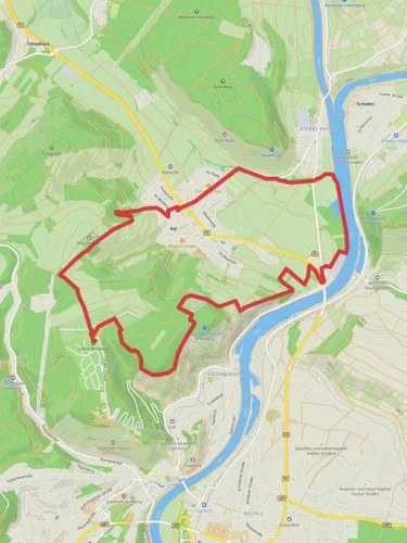
12.4 km
~3 hrs 12 min
431 m
“The Mannebach Loop is a scenic 12 km trail in Germany, blending natural beauty and moderate challenge.”
Starting near Trier-Saarburg, Germany, the Mannebach Loop is a scenic 12 km (7.5 miles) trail with an elevation gain of approximately 400 meters (1,312 feet). This loop trail is rated as medium difficulty, making it suitable for moderately experienced hikers.
### Getting There To reach the trailhead, you can drive or use public transport. If driving, set your GPS to Mannebach, a small village near Trier-Saarburg. For those using public transport, take a train to Trier and then a local bus to Mannebach. The nearest significant landmark is the Mannebach Brewery, which is a short walk from the trailhead.
### Trail Overview The trail begins in the quaint village of Mannebach, known for its picturesque landscapes and traditional German architecture. As you start your hike, you'll be greeted by rolling hills and lush forests. The first 2 km (1.2 miles) are relatively flat, allowing you to ease into the hike while enjoying the serene surroundings.
### Key Landmarks and Points of Interest #### Mannebach Brewery At the start of your hike, you’ll pass by the Mannebach Brewery, a local gem known for its craft beers. It’s worth noting for a post-hike refreshment.
#### Forested Sections Around the 3 km (1.9 miles) mark, you’ll enter a dense forest. This section is particularly beautiful in autumn when the leaves change color. The forest is home to various wildlife, including deer and numerous bird species, so keep your eyes peeled.
#### Elevation Gain As you approach the 5 km (3.1 miles) point, the trail begins to ascend. This is where you’ll encounter the most significant elevation gain. The climb is steady but manageable, offering panoramic views of the surrounding countryside as a reward.
#### Historical Significance At approximately 7 km (4.3 miles), you’ll come across remnants of ancient Roman roads. Trier, being one of the oldest cities in Germany, has a rich Roman history, and these roads are a testament to that era. Take a moment to appreciate the historical significance of the area.
### Navigation and Safety The trail is well-marked, but it’s always a good idea to have a reliable navigation tool. HiiKER is recommended for its detailed maps and real-time updates. Ensure you have adequate water and snacks, as there are no facilities along the trail.
### Final Stretch The last 3 km (1.9 miles) of the trail are a gentle descent back into Mannebach. This section offers more open landscapes, with fields and meadows that are especially beautiful in the spring and summer months.
### Wildlife and Flora Throughout the hike, you’ll encounter a variety of flora, including wildflowers and ancient oak trees. The area is also home to foxes, badgers, and a variety of bird species, making it a great trail for nature enthusiasts.
### Practical Tips - Wear sturdy hiking boots, as some sections can be rocky and uneven. - Check the weather forecast before heading out, as the trail can become slippery in wet conditions. - Bring a camera to capture the stunning landscapes and historical sites.
The Mannebach Loop offers a perfect blend of natural beauty, historical intrigue, and moderate physical challenge, making it a rewarding experience for any hiker.
Reviews
User comments, reviews and discussions about the Mannebach Loop, Germany.
5.0
average rating out of 5
5 rating(s)


