10.2 km
~2 hrs 57 min
553 m
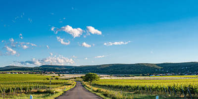
“Explore the Südliche Weinstraße trail for stunning vistas, moderate challenges, and rich historical intrigue.”
Starting near the picturesque region of Südliche Weinstraße in Germany, this 10 km (6.2 miles) loop trail offers a delightful mix of natural beauty, moderate physical challenge, and historical intrigue. With an elevation gain of approximately 500 meters (1,640 feet), hikers can expect a moderately challenging experience that rewards them with stunning vistas and rich cultural history.
### Getting There To reach the trailhead, you can either drive or use public transport. If driving, head towards the Südliche Weinstraße area, where ample parking is available near the trailhead. For those using public transport, the nearest significant landmark is the town of Neustadt an der Weinstraße. From there, local buses can take you closer to the trailhead.
### Trail Highlights
#### Hohe Loog Starting your hike, you'll first encounter the Hohe Loog, a prominent peak in the Palatinate Forest. The initial ascent is gradual, allowing you to warm up as you make your way through dense forests of oak and beech. At approximately 2 km (1.2 miles) into the hike, you'll reach the Hohe Loog Haus, a charming mountain hut where you can take a short break and enjoy panoramic views of the surrounding valleys.
#### Zwerchberg Continuing on, the trail leads you to Zwerchberg. This section is relatively flat, providing a welcome respite from the initial climb. The area is known for its diverse flora, including wildflowers and various species of ferns. Keep an eye out for local wildlife such as deer and various bird species. This part of the trail is perfect for nature enthusiasts and photographers alike.
#### Kalmit At around the 5 km (3.1 miles) mark, you'll begin your ascent to Kalmit, the highest peak in the Palatinate Forest at 673 meters (2,208 feet). The climb is steep but manageable, with well-marked paths guiding you to the summit. Once at the top, you'll be rewarded with breathtaking views that stretch as far as the Rhine Valley. The summit also features a weather station and a small café, where you can rest and refuel.
#### Taubenkopf The final significant landmark on this loop is Taubenkopf. As you descend from Kalmit, the trail meanders through a mix of coniferous and deciduous forests. This section is less frequented, offering a peaceful and serene environment. At approximately 8 km (5 miles) into the hike, you'll reach Taubenkopf, a lesser-known peak that provides a quieter but equally stunning viewpoint.
### Historical Significance The Palatinate Forest, where this trail is located, has a rich history dating back to Roman times. The region was historically significant for its strategic location and natural resources. Throughout the hike, you'll come across remnants of ancient fortifications and old stone walls, offering a glimpse into the area's storied past.
### Navigation and Safety Given the moderate difficulty of this trail, it's advisable to use a reliable navigation tool like HiiKER to ensure you stay on track. The trail is well-marked, but having a digital map can provide additional peace of mind. Wear sturdy hiking boots, bring plenty of water, and be prepared for changing weather conditions, especially at higher elevations.
This loop trail offers a perfect blend of natural beauty, physical challenge, and historical intrigue, making it a must-visit for any hiking enthusiast.

Reviews
User comments, reviews and discussions about the Hohe Loog, Zwerchberg, Kalmit and Taubenkopf Loop, Germany.
4.0
average rating out of 5
4 rating(s)