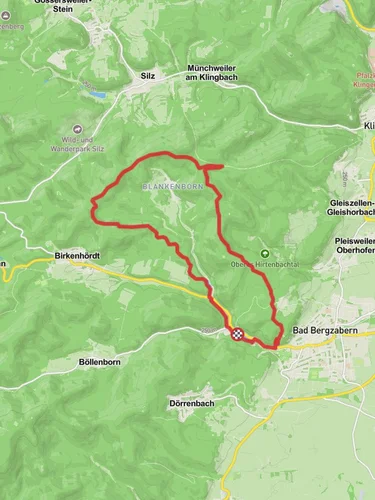
11.0 km
~3 hrs 4 min
523 m
“Discover the Birkenhoerdter Hoehenweg: an 11 km trail blending natural beauty, history, and stunning vistas.”
Starting near the charming region of Südliche Weinstraße in Germany, the Birkenhoerdter Hoehenweg is a captivating loop trail that spans approximately 11 km (around 6.8 miles) with an elevation gain of about 500 meters (1,640 feet). This medium-difficulty trail offers a delightful mix of natural beauty, historical landmarks, and panoramic views, making it a rewarding experience for hikers.
### Getting There To reach the trailhead, you can either drive or use public transport. If you're driving, set your GPS to the vicinity of Südliche Weinstraße, Germany. For those opting for public transport, the nearest significant landmark is the town of Bad Bergzabern. From there, local buses or a short taxi ride can take you to the trailhead.
### Trail Navigation and Terrain The trail is well-marked, but it's always a good idea to have a reliable navigation tool like HiiKER to ensure you stay on track. The terrain varies from forest paths to open meadows, with some sections being rocky and uneven. Good hiking boots are recommended to handle the diverse surfaces.
### Key Landmarks and Points of Interest - Start to 2 km (1.2 miles): The initial part of the trail takes you through dense forests, where you can enjoy the serene ambiance and the sound of rustling leaves. Keep an eye out for local wildlife such as deer and various bird species. - 2 km to 5 km (1.2 to 3.1 miles): As you ascend, you'll come across the first significant viewpoint. This spot offers a breathtaking panorama of the Südliche Weinstraße region, with its rolling hills and vineyards stretching out below. - 5 km to 7 km (3.1 to 4.3 miles): The trail then leads you to a historical landmark, the remnants of an old Roman road. This section is a gentle reminder of the region's rich history, dating back to ancient times when the Romans used these paths for trade and travel. - 7 km to 9 km (4.3 to 5.6 miles): Continuing along, you'll pass through more open areas, where wildflowers bloom in abundance during the spring and summer months. This is a great spot for a picnic or a short rest. - 9 km to 11 km (5.6 to 6.8 miles): The final stretch of the trail descends back into the forest, leading you back to the starting point. This section is relatively easier, allowing you to cool down and reflect on the journey.
### Flora and Fauna The Birkenhoerdter Hoehenweg is home to a diverse range of flora and fauna. Depending on the season, you might encounter wild boars, foxes, and a variety of bird species. The forested areas are rich with oak, beech, and pine trees, while the meadows are dotted with wildflowers like daisies and poppies.
### Historical Significance The region around Südliche Weinstraße has a deep historical significance. The remnants of the Roman road you encounter on the trail are a testament to the area's ancient past. This road was once a crucial part of the Roman Empire's extensive network, facilitating trade and movement across Europe.
### Practical Tips - Weather: Check the weather forecast before you set out. The trail can be slippery after rain, and fog can reduce visibility. - Supplies: Carry enough water and snacks, as there are no facilities along the trail. - Clothing: Dress in layers, as the weather can change rapidly, especially at higher elevations.
By preparing adequately and being aware of what to expect, you can fully enjoy the natural beauty and historical richness that the Birkenhoerdter Hoehenweg has to offer.
Reviews
User comments, reviews and discussions about the Birkenhoerdter Hoehenweg, Germany.
0.0
average rating out of 5
0 rating(s)


