4.9 km
~1 hrs 30 min
313 m
“A moderate 5 km loop trail near Schwarzwald-Baar-Kreis, Germany, blends scenic beauty, history, and wildlife.”
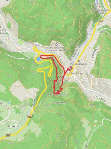
Starting near Schwarzwald-Baar-Kreis, Germany, the Bergsee via Kroneckweg and Ortenau Baar Weg is a picturesque loop trail that spans approximately 5 kilometers (3.1 miles) with an elevation gain of around 300 meters (984 feet). This medium-difficulty trail offers a blend of natural beauty, historical significance, and a moderate challenge suitable for most hikers.
### Getting There To reach the trailhead, you can drive or use public transport. If driving, set your GPS to Schwarzwald-Baar-Kreis, and look for parking near the trailhead. For those using public transport, take a train to Villingen-Schwenningen, the nearest major town, and then a local bus to the Schwarzwald-Baar-Kreis area. From there, it's a short walk to the trailhead.
### Trail Navigation For navigation, use the HiiKER app to ensure you stay on the correct path. The trail is well-marked, but having a reliable navigation tool can enhance your experience and provide peace of mind.
### Trail Highlights The trail begins with a gentle ascent through dense forest, where you'll be surrounded by towering pine trees and the occasional oak. About 1 kilometer (0.6 miles) in, you'll come across a small clearing with a panoramic view of the surrounding Black Forest region. This is an excellent spot for a quick rest and some photos.
### Historical Significance As you continue, you'll encounter several historical markers. The region has a rich history dating back to Roman times, and you'll find remnants of ancient Roman roads and boundary stones. These markers provide a fascinating glimpse into the area's past and are well worth a moment of reflection.
### Flora and Fauna The trail is abundant with local flora and fauna. Keep an eye out for deer, foxes, and a variety of bird species. In spring and summer, the forest floor is carpeted with wildflowers, adding a splash of color to your hike. The Bergsee, a small but serene lake, is located about 3 kilometers (1.9 miles) into the hike. This is a perfect spot for a longer break, where you can enjoy the tranquility of the water and perhaps spot some aquatic birds.
### Elevation and Terrain The trail's elevation gain is gradual but steady. The most challenging section is the ascent to the highest point, which is about 2 kilometers (1.2 miles) from the start. Here, you'll gain approximately 150 meters (492 feet) in elevation over a relatively short distance. The terrain can be rocky and uneven, so sturdy hiking boots are recommended.
### Final Stretch The descent begins after you pass the highest point, leading you back through the forest. The final stretch of the trail is a gentle downhill walk, bringing you back to the trailhead. Along the way, you'll pass through a picturesque meadow, which is particularly beautiful in the late afternoon light.
### Practical Tips - Wear sturdy hiking boots due to the rocky terrain. - Bring water and snacks, as there are no facilities along the trail. - Check the weather forecast before you go; the trail can be slippery after rain. - Use the HiiKER app for navigation to stay on track.
This trail offers a rewarding hike with a mix of natural beauty, historical interest, and moderate physical challenge, making it a perfect day hike for those exploring the Black Forest region.
Reviews
User comments, reviews and discussions about the Bergsee via Kroneckweg and Ortenau Baar Weg, Germany.
5.0
average rating out of 5
5 rating(s)


