9.0 km
~2 hrs 5 min
181 m
“Explore Schaumburg's scenic 9 km trail, rich in natural beauty, historical sites, and diverse wildlife.”
Starting near the picturesque town of Schaumburg, Germany, the Bremsschacht and Dachtelfeldweg trail offers a delightful 9 km (5.6 miles) loop with an elevation gain of approximately 100 meters (328 feet). This medium-difficulty trail is perfect for those looking to immerse themselves in the natural beauty and historical richness of the region.
### Getting There To reach the trailhead, you can either drive or use public transport. If driving, set your GPS to Schaumburg, Germany, and look for parking near the town center. For those using public transport, take a train to Stadthagen station, which is the nearest major railway hub. From Stadthagen, you can catch a local bus or taxi to Schaumburg.
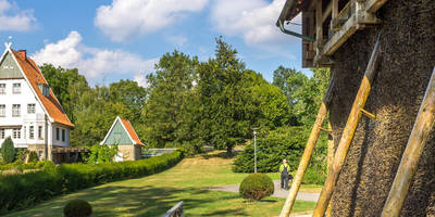
### Trail Overview The trail begins near Schaumburg, winding through lush forests and open fields. The initial section is relatively flat, making it a good warm-up for the more undulating terrain ahead. As you progress, you'll encounter a mix of dirt paths and gravel roads, all well-marked and easy to follow.
### Key Landmarks and Points of Interest - Bremsschacht: About 3 km (1.9 miles) into the hike, you'll come across the Bremsschacht, an old mining shaft that dates back to the 19th century. This site offers a glimpse into the region's industrial past and is a great spot for a short break. - Dachtelfeld: Around the 6 km (3.7 miles) mark, you'll reach the Dachtelfeld, a beautiful open meadow that provides stunning views of the surrounding landscape. This is an ideal location for a picnic or simply to take in the scenery.
### Flora and Fauna The trail is rich in biodiversity. You'll walk through dense forests of oak and beech trees, and during spring and summer, the path is lined with wildflowers. Keep an eye out for local wildlife, including deer, foxes, and a variety of bird species. The area is also known for its butterflies, particularly in the warmer months.
### Historical Significance The region around Schaumburg has a deep historical significance. The nearby Schaumburg Castle, although not directly on the trail, is worth a visit either before or after your hike. The castle dates back to the 12th century and offers panoramic views of the Weser Uplands.
### Navigation and Safety For navigation, it's highly recommended to use the HiiKER app, which provides detailed maps and real-time updates. The trail is generally well-marked, but having a reliable navigation tool will ensure you stay on track.
### Final Stretch The last 3 km (1.9 miles) of the trail loop back towards Schaumburg, gradually descending through a series of gentle slopes. This section is particularly scenic, with views of the town and the surrounding countryside.
### Preparation Tips - Footwear: Sturdy hiking boots are recommended due to the mixed terrain. - Weather: Check the weather forecast before you go, as the trail can become slippery in wet conditions. - Supplies: Bring enough water and snacks, especially if you plan to picnic at Dachtelfeld. - Clothing: Dress in layers, as the weather can change rapidly.
This trail offers a perfect blend of natural beauty, historical intrigue, and moderate physical challenge, making it a rewarding experience for any hiker.
Reviews
User comments, reviews and discussions about the Bremsschacht and Dachtelfeldweg, Germany.
0.0
average rating out of 5
0 rating(s)


