13.6 km
~3 hrs 18 min
360 m
“Explore the picturesque Rheinisch-Bergischer Kreis with this 14 km loop trail featuring valleys, heights, and water routes.”
Starting near the picturesque region of Rheinisch-Bergischer Kreis in Germany, this 14 km (8.7 miles) loop trail offers a delightful mix of valleys, heights, and water routes. With an elevation gain of approximately 300 meters (984 feet), the trail is rated as medium difficulty, making it suitable for moderately experienced hikers.
### Getting There To reach the trailhead, you can drive or use public transport. If driving, set your GPS to the nearest known address: Bergisch Gladbach, a charming town in the Rheinisch-Bergischer Kreis. For those using public transport, take a train to Bergisch Gladbach station. From there, local buses can take you closer to the trailhead, or you can opt for a short taxi ride.
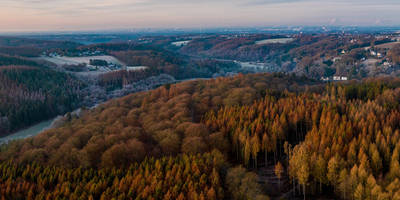
### Trail Highlights #### Valleys and Heights The trail begins with a gentle ascent through lush valleys, where you'll be surrounded by dense forests and the soothing sounds of nature. As you climb higher, the landscape opens up to offer panoramic views of the surrounding hills and valleys. This section is particularly beautiful in the early morning when the mist hangs low over the landscape.
#### Water Routes One of the most captivating features of this trail is its water routes. You'll encounter several small streams and brooks, which add a refreshing element to the hike. Around the 5 km (3.1 miles) mark, you'll come across a serene lake, perfect for a short break. The water is crystal clear, reflecting the surrounding greenery and sky.
### Historical Significance The region is steeped in history, with several landmarks that date back to medieval times. Around the 8 km (5 miles) point, you'll pass by the ruins of an old castle, which offers a glimpse into the area's rich past. The castle, though mostly in ruins, still stands as a testament to the architectural prowess of the time. Information boards provide historical context, making it a great spot for a brief educational stop.
### Flora and Fauna The trail is a haven for nature enthusiasts. The forests are home to a variety of wildlife, including deer, foxes, and numerous bird species. Keep an eye out for the European robin and the great spotted woodpecker, both of which are commonly seen in this area. The flora is equally diverse, with oak, beech, and pine trees dominating the landscape. In spring and summer, the forest floor is carpeted with wildflowers, adding a splash of color to your hike.
### Navigation and Safety Given the trail's moderate difficulty, it's advisable to use a reliable navigation tool like HiiKER to stay on track. The trail is well-marked, but having a digital map can be incredibly useful, especially in the more remote sections. Wear sturdy hiking boots, as some parts of the trail can be rocky and uneven. Carry enough water and snacks, as there are limited facilities along the route.
### Final Stretch The last few kilometers of the trail take you through a series of gentle descents, leading you back to the starting point. This section is relatively easy, allowing you to cool down and reflect on the beautiful landscapes you've just traversed. The loop nature of the trail means you'll end up right where you started, making logistics simple and straightforward.
This trail offers a perfect blend of natural beauty, historical intrigue, and moderate physical challenge, making it a must-visit for any hiking enthusiast.

Reviews
User comments, reviews and discussions about the Taeler und Hoehen and Wasserroute, Germany.
5.0
average rating out of 5
4 rating(s)