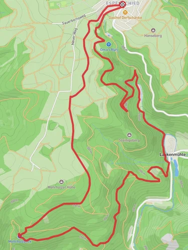
12.1 km
~3 hrs 3 min
375 m
“Explore the scenic Wisper Trail, offering lush valleys, historic ruins, and panoramic viewpoints in Rheingau-Taunus.”
Starting near Rheingau-Taunus-Kreis in Germany, this 12 km (7.5 miles) loop trail offers a moderate hiking experience with an elevation gain of approximately 300 meters (984 feet). The trailhead is conveniently accessible by both public transport and car. If you're driving, you can park near the village of Espenschied, which is a good starting point. For those using public transport, take a train to Lorch and then a bus to Espenschied.
### Trail Overview
The Wisper Trail and Rundweg Eule Loop is a scenic journey through the picturesque landscapes of the Rheingau-Taunus region. The trail is well-marked and offers a variety of terrains, including forest paths, open meadows, and gentle hills. The elevation gain is gradual, making it suitable for hikers with a moderate level of fitness.
### Key Landmarks and Points of Interest
#### Wisper Valley As you begin your hike, you'll quickly find yourself immersed in the serene beauty of the Wisper Valley. This area is known for its lush greenery and the gentle flow of the Wisper River. The valley is home to a variety of wildlife, including deer and numerous bird species, so keep your eyes peeled.
#### Eulenberg Viewpoint Approximately 4 km (2.5 miles) into the hike, you'll reach the Eulenberg Viewpoint. This spot offers panoramic views of the surrounding countryside and is an excellent place to take a break and enjoy the scenery. The elevation gain to this point is about 150 meters (492 feet), making it a moderate climb.
#### Historical Significance The Rheingau-Taunus region is steeped in history, and you'll encounter several historical landmarks along the trail. One notable site is the remnants of ancient Roman watchtowers, which were part of the Limes Germanicus, a line of frontier fortifications that marked the boundaries of the Roman Empire. These ruins are located around the 8 km (5 miles) mark and offer a fascinating glimpse into the area's past.
### Flora and Fauna
The trail is rich in biodiversity. In the spring and summer months, you'll find a variety of wildflowers, including orchids and lilies, adding vibrant colors to the landscape. The forested sections are predominantly composed of beech and oak trees, providing ample shade and a cool respite during warmer days.
### Navigation and Safety
For navigation, it's highly recommended to use the HiiKER app, which provides detailed maps and real-time updates. The trail is generally well-maintained, but it's always a good idea to check for any alerts or updates before you set out.
### Getting There
To reach the trailhead by car, set your GPS to Espenschied, Rheingau-Taunus-Kreis. There is ample parking available near the village. If you're using public transport, take a train to Lorch and then a bus to Espenschied. The bus service is reliable, but it's advisable to check the schedule in advance to plan your trip accordingly.
### Final Stretch
The last few kilometers of the trail take you through open meadows and gently rolling hills, gradually descending back to your starting point. This section is relatively easy and offers a relaxing end to your hike. The total elevation gain for the entire loop is around 300 meters (984 feet), making it a manageable yet rewarding hike.
This trail offers a perfect blend of natural beauty, historical intrigue, and moderate physical challenge, making it a must-visit for any hiking enthusiast exploring the Rheingau-Taunus region.
Reviews
User comments, reviews and discussions about the Wisper Trail and Rundweg Eule Loop, Germany.
5.0
average rating out of 5
6 rating(s)


