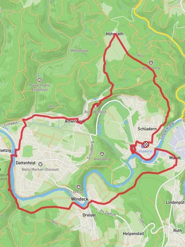
13.5 km
~2 hrs 52 min
106 m
“Experience lush greenery, historical landmarks, and tranquil river views on this scenic 13 km Siegtal Radweg trail.”
Starting near the Rhein-Sieg-Kreis in Germany, this 13 km (approximately 8 miles) out-and-back trail offers a moderate hiking experience with an elevation gain of around 100 meters (328 feet). The trail is part of the Siegtal Radweg, a scenic route that follows the Sieg River, providing hikers with picturesque views and a tranquil atmosphere.
### Getting There To reach the trailhead, you can either drive or use public transport. If driving, set your GPS to the nearest significant landmark, which is the town of Siegburg. From Siegburg, follow local roads to reach the trailhead near the Sieg River. For those using public transport, take a train to Siegburg/Bonn station. From there, local buses or a short taxi ride will get you to the starting point.
### Trail Navigation Using HiiKER for navigation is highly recommended. The app provides detailed maps and real-time updates, ensuring you stay on the right path throughout your hike.
### Trail Highlights As you begin your hike, you'll immediately notice the lush greenery that surrounds the Sieg River. The trail is well-marked and follows the river closely, offering numerous opportunities to spot local wildlife such as deer, foxes, and a variety of bird species.
### Historical Significance The region around the Sieg River has a rich history. During your hike, you'll come across several historical landmarks. One notable site is the medieval Blankenberg Castle, located approximately 5 km (3 miles) into the hike. The castle ruins offer a glimpse into the area's past and provide a fantastic vantage point for panoramic views of the Sieg Valley.
### Nature and Wildlife The trail is abundant with flora and fauna. Depending on the season, you might see wildflowers in full bloom, adding vibrant colors to your journey. The river itself is home to various fish species, and if you're lucky, you might even spot a kingfisher diving for its next meal.
### Elevation and Terrain The trail's elevation gain is moderate, making it suitable for hikers with a reasonable level of fitness. The terrain is a mix of dirt paths and gravel, with some sections that can be muddy after rain. Good hiking boots are recommended to navigate these areas comfortably.
### Points of Interest Around the 8 km (5 miles) mark, you'll reach a scenic viewpoint that offers a stunning panorama of the surrounding landscape. This is an excellent spot for a break and some photography.
### Return Journey Since this is an out-and-back trail, you'll retrace your steps to return to the trailhead. The return journey offers a different perspective of the same beautiful scenery, making it equally enjoyable.
### Practical Tips - Carry enough water and snacks, as there are limited facilities along the trail. - Check the weather forecast before heading out, as conditions can change rapidly. - Use HiiKER for real-time navigation and updates.
This trail offers a perfect blend of natural beauty, historical landmarks, and moderate physical challenge, making it a rewarding experience for any hiker.
Reviews
User comments, reviews and discussions about the Sieg via Siegtal Radweg, Germany.
0.0
average rating out of 5
0 rating(s)


