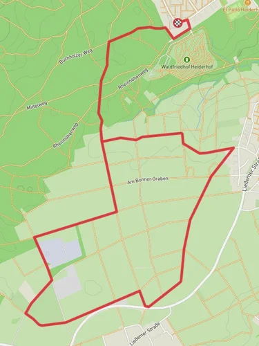
13.8 km
~3 hrs 6 min
210 m
“Embark on a picturesque 14 km hike through lush forests, historical sites, and scenic vistas in Rhein-Sieg-Kreis.”
Starting your hike near Rhein-Sieg-Kreis, Germany, the Rund um Wachtberg and Kottenforstweg Loop offers a delightful 14 km (approximately 8.7 miles) journey through picturesque landscapes and historical sites. With an elevation gain of around 200 meters (656 feet), this loop trail is rated as medium difficulty, making it suitable for moderately experienced hikers.
### Getting There To reach the trailhead, you can either drive or use public transport. If driving, set your GPS to Rhein-Sieg-Kreis, Germany, and look for parking options near the trailhead. For public transport, take a train to Bonn Hauptbahnhof and then a bus to the Wachtberg area. The nearest significant landmark to the trailhead is the Drachenfels Railway Station, which is well-connected and offers a convenient starting point.
### Trail Highlights and Navigation The trail begins with a gentle ascent, leading you through lush forests and open meadows. Early on, you'll encounter the Kottenforst, a historic forest known for its diverse flora and fauna. Keep an eye out for native wildlife such as deer, foxes, and a variety of bird species. The forest is also home to ancient oak and beech trees, some of which are centuries old.
#### Historical Significance As you progress, you'll come across several historical landmarks. One notable site is the remnants of Roman fortifications, offering a glimpse into the region's ancient past. The area around Wachtberg has been inhabited since Roman times, and you may even find old Roman roads and boundary stones along the way.
### Mid-Trail Features Around the halfway point, approximately 7 km (4.3 miles) into the hike, you'll reach the Wachtberg plateau. This area provides stunning panoramic views of the surrounding countryside, including the Siebengebirge mountain range and the Rhine River. It's an excellent spot for a rest and some photography.
Continuing on, the trail descends slightly, leading you through more forested areas and past small streams. The terrain here is relatively easy, but be mindful of occasional muddy patches, especially after rain. Using HiiKER for navigation can help you stay on track and avoid any confusing intersections.
### Final Stretch As you near the end of the loop, the trail takes you through charming rural villages, where you can observe traditional German architecture and perhaps stop for a snack at a local café. The final stretch is a gentle downhill walk, bringing you back to the trailhead near Rhein-Sieg-Kreis.
### Preparation Tips Given the moderate difficulty of the trail, it's advisable to wear sturdy hiking boots and bring plenty of water. The trail is well-marked, but having a map on HiiKER can be very useful for navigation. Weather can be unpredictable, so pack a light rain jacket and check the forecast before heading out.
This trail offers a perfect blend of natural beauty, historical intrigue, and moderate physical challenge, making it a rewarding experience for any hiker.
Reviews
User comments, reviews and discussions about the Rund um Wachtberg and Kpttenforstweg Loop, Germany.
5.0
average rating out of 5
2 rating(s)


