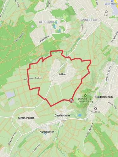
13.2 km
~3 hrs 12 min
339 m
“The Rund um Wachtberg trail offers scenic beauty, historical landmarks, and panoramic views, perfect for adventurous hikers.”
Starting near Rhein-Sieg-Kreis, Germany, the Rund um Wachtberg trail is a scenic loop that spans approximately 13 kilometers (8 miles) with an elevation gain of around 300 meters (984 feet). This medium-difficulty trail offers a delightful mix of natural beauty, historical landmarks, and panoramic views, making it a rewarding experience for hikers.
### Getting There To reach the trailhead, you can either drive or use public transport. If driving, set your GPS to the nearest known address: Rathausstraße 34, 53343 Wachtberg, Germany. There is parking available near the trailhead. For those using public transport, take a train to Bonn Hauptbahnhof and then a bus to Wachtberg. The bus stop closest to the trailhead is Wachtberg Rathaus, just a short walk from the starting point.
### Trail Navigation For navigation, it is highly recommended to use the HiiKER app, which provides detailed maps and real-time updates to ensure you stay on track.
### Trail Highlights
#### Nature and Wildlife The trail meanders through a variety of landscapes, including dense forests, open meadows, and rolling hills. Keep an eye out for local wildlife such as deer, foxes, and a variety of bird species. The flora is equally diverse, with wildflowers blooming in the spring and summer, and vibrant foliage in the autumn.
#### Historical Significance One of the notable landmarks along the trail is the Wachtberg Castle ruins, located approximately 5 kilometers (3.1 miles) into the hike. The castle dates back to the medieval period and offers a glimpse into the region's rich history. Another significant site is the Roman aqueduct remnants, found around the 8-kilometer (5-mile) mark. These ancient structures highlight the engineering prowess of the Romans and their influence in the region.
### Elevation and Terrain The trail features a moderate elevation gain of around 300 meters (984 feet), with several ascents and descents. The initial part of the trail is relatively flat, making it a good warm-up before you encounter steeper sections. The highest point of the trail offers stunning views of the surrounding countryside and the Rhine River valley.
### Points of Interest - Wachtberg Castle Ruins: Located 5 kilometers (3.1 miles) into the hike, these ruins are a must-see for history enthusiasts. - Roman Aqueduct Remnants: Found around the 8-kilometer (5-mile) mark, these ancient structures are a testament to Roman engineering. - Panoramic Viewpoints: Several spots along the trail offer breathtaking views of the Rhine River valley and the surrounding hills.
### Preparation Tips - Footwear: Wear sturdy hiking boots with good ankle support, as the terrain can be uneven and rocky in places. - Water and Snacks: Carry enough water and snacks to keep you energized, especially if you plan to take breaks at the various points of interest. - Weather: Check the weather forecast before heading out and dress in layers, as the weather can change rapidly in this region. - Navigation: Use the HiiKER app for real-time navigation and updates.
This trail offers a perfect blend of natural beauty, historical landmarks, and moderate physical challenge, making it an ideal choice for hikers looking to explore the scenic and historical richness of the Rhein-Sieg-Kreis region.
Reviews
User comments, reviews and discussions about the Rund um Wachtberg, Germany.
0.0
average rating out of 5
0 rating(s)


