8.7 km
~2 hrs 9 min
260 m
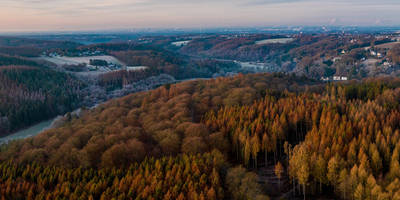
“Explore a 9 km trail in Rhein-Sieg-Kreis blending lush forests, historic landmarks, and panoramic views.”
Starting near Rhein-Sieg-Kreis, Germany, this 9 km (approximately 5.6 miles) loop trail offers a delightful mix of natural beauty and historical intrigue. With an elevation gain of around 200 meters (656 feet), it is rated as a medium difficulty hike, making it suitable for moderately experienced hikers.
### Getting There To reach the trailhead, you can drive or use public transport. If driving, set your GPS to Rhein-Sieg-Kreis, Germany, and look for parking near the trailhead. For public transport, take a train to the nearest station in Rhein-Sieg-Kreis and then a local bus or taxi to the trailhead. The area is well-connected, making it relatively easy to access.
### Trail Overview The trail begins with a gentle ascent through lush forests, where you'll be greeted by the soothing sounds of the Halberger Bach stream. The first section is relatively easy, allowing you to warm up as you navigate through the dense foliage. Keep an eye out for various bird species and small mammals that inhabit this area.
### Significant Landmarks and Nature At around the 2 km (1.2 miles) mark, you'll come across the Stationsweg, a historical path that has been used by pilgrims for centuries. This section of the trail is particularly rich in history, with several old stone markers and small chapels dotting the route. Take a moment to appreciate the craftsmanship and the historical significance of these landmarks.
Continuing along the trail, you'll reach a viewpoint at approximately 4 km (2.5 miles) into the hike. Here, you can take a break and enjoy panoramic views of the surrounding countryside. The elevation gain to this point is about 100 meters (328 feet), making it a moderate climb but well worth the effort for the stunning vistas.
### Flora and Fauna As you descend from the viewpoint, the trail meanders through open meadows and mixed woodlands. This section is particularly vibrant in spring and summer, with wildflowers in full bloom and butterflies fluttering about. The diversity of plant life is impressive, ranging from towering oaks to delicate ferns.
### Final Stretch The last 3 km (1.9 miles) of the trail take you back through the Halberger Bachtal, a serene valley that offers a peaceful end to your hike. The descent is gradual, making it a comfortable walk back to the trailhead. Along the way, you'll pass by several small ponds and wetlands, which are home to frogs, dragonflies, and other aquatic life.
### Navigation For navigation, it's highly recommended to use the HiiKER app, which provides detailed maps and real-time updates to ensure you stay on track. The trail is well-marked, but having a reliable navigation tool can enhance your hiking experience and provide peace of mind.
This trail offers a perfect blend of natural beauty, historical landmarks, and moderate physical challenge, making it a rewarding experience for any hiker.
Reviews
User comments, reviews and discussions about the NSG Halberger Bachtal and Vom Pilger zum Flaneur via Stationsweg, Germany.
0.0
average rating out of 5
0 rating(s)


