13.2 km
~3 hrs 44 min
664 m
“The Gelbachhoehen Tour is a scenic 13-kilometer hike blending natural beauty, history, and wildlife.”
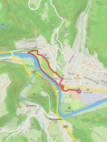
Starting near Rhein-Lahn-Kreis, Germany, the Gelbachhoehen Tour is a captivating loop trail that spans approximately 13 kilometers (8 miles) with an elevation gain of around 600 meters (1,969 feet). This medium-difficulty hike offers a blend of natural beauty, historical landmarks, and diverse wildlife, making it a rewarding experience for outdoor enthusiasts.
### Getting There To reach the trailhead, you can drive or use public transport. If driving, set your GPS to the nearest significant landmark, which is the town of Nassau, located in the Rhein-Lahn-Kreis district. From Nassau, follow local signage to the trailhead. For those using public transport, take a train to Nassau Bahnhof (Nassau Train Station). From there, local buses or a short taxi ride will get you to the starting point.
### Trail Overview The Gelbachhoehen Tour begins with a gentle ascent through dense forests, offering a serene start to your hike. As you progress, the trail becomes steeper, gaining elevation steadily. The first significant landmark you'll encounter is the Gelbach River, a picturesque waterway that meanders through the landscape. This section is particularly lush, with a variety of flora including oak, beech, and pine trees.
### Historical Significance Around the 5-kilometer (3.1-mile) mark, you'll come across the ruins of an old mill, a testament to the region's historical reliance on water-powered industry. This area was once bustling with activity, and the remnants of the mill provide a fascinating glimpse into the past. Take a moment to explore the ruins and imagine the lives of those who worked here centuries ago.
### Wildlife and Nature As you continue, the trail opens up to expansive meadows, where you're likely to spot local wildlife such as deer, foxes, and a variety of bird species. Keep an eye out for the European Green Woodpecker and the Common Buzzard, both of which are frequently seen in this area. The meadows also offer stunning views of the surrounding hills and valleys, making it a perfect spot for a rest and some photography.
### Navigation and Safety Navigating the Gelbachhoehen Tour is straightforward, but it's always wise to have a reliable navigation tool. The HiiKER app is highly recommended for its detailed maps and real-time updates. The trail is well-marked with signs, but having HiiKER as a backup ensures you stay on track.
### Final Stretch The final stretch of the trail takes you through a series of rolling hills, gradually descending back towards the starting point. This section is less strenuous, allowing you to enjoy the panoramic views and reflect on the journey. As you near the end, you'll pass through a charming village where you can stop for refreshments and soak in the local culture.
### Practical Tips - Wear sturdy hiking boots, as some sections can be rocky and uneven. - Bring plenty of water and snacks, especially during warmer months. - Check the weather forecast before you go; the trail can be slippery after rain. - Be mindful of local wildlife and maintain a respectful distance.
The Gelbachhoehen Tour offers a perfect blend of natural beauty, historical intrigue, and physical challenge, making it a must-visit for hikers in the region.
Reviews
User comments, reviews and discussions about the Gelbachhoehen Tour, Germany.
4.0
average rating out of 5
7 rating(s)


