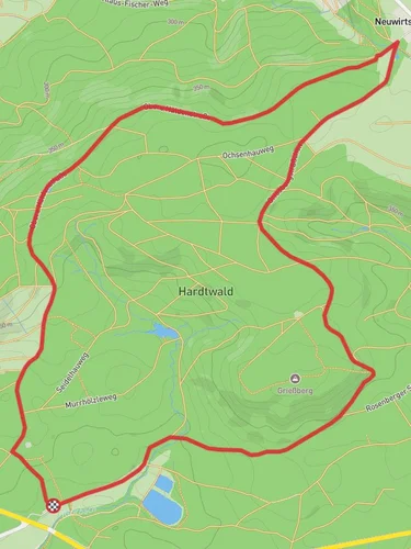
9.1 km
~2 hrs 13 min
247 m
“"Explore a 9 km scenic loop through lush forests, historic sites, and panoramic views in Rems-Murr-Kreis."”
Starting your hike near Rems-Murr-Kreis, Germany, the Hintervohrenberg, Vordervohrenberg, and Steinhausen Loop offers a delightful 9 km (approximately 5.6 miles) journey with an elevation gain of around 200 meters (656 feet). This loop trail is rated as medium difficulty, making it suitable for moderately experienced hikers.
### Getting There To reach the trailhead, you can drive or use public transportation. If driving, set your GPS to Rems-Murr-Kreis, Germany, and look for parking near the trailhead. For public transport, take a train or bus to the nearest station in Rems-Murr-Kreis and then a short taxi ride or local bus to the starting point.
### Trail Navigation Using HiiKER for navigation is highly recommended to ensure you stay on track and make the most of your hike. The app provides detailed maps and real-time updates.
### Trail Highlights The trail begins with a gentle ascent through lush forests, offering a serene start to your hike. As you progress, you'll encounter the first significant landmark, the Hintervohrenberg, around 2 km (1.2 miles) into the hike. This area is known for its dense woodland and occasional sightings of local wildlife such as deer and various bird species.
### Vordervohrenberg Continuing on, you'll reach Vordervohrenberg at approximately the 4 km (2.5 miles) mark. This section of the trail provides panoramic views of the surrounding valleys and hills. The elevation gain here is more noticeable, but the well-maintained path makes the ascent manageable. Keep an eye out for wildflowers and unique rock formations that add to the trail's charm.
### Steinhausen The final significant landmark is Steinhausen, located around 7 km (4.3 miles) into the loop. Steinhausen is historically significant, with remnants of ancient settlements and old farmhouses that tell the story of the region's past. This area also offers a great spot for a rest, with benches and picnic areas available.
### Flora and Fauna Throughout the hike, you'll be surrounded by a variety of flora, including oak, beech, and pine trees. The diverse plant life supports a range of wildlife, so keep your camera ready for potential sightings of foxes, hares, and numerous bird species.
### Final Stretch The last 2 km (1.2 miles) of the trail lead you back to the starting point, with a gentle descent that allows you to cool down and reflect on the beautiful landscapes you've traversed. The loop nature of the trail ensures you end where you began, making logistics simple.
### Historical Significance The region around Rems-Murr-Kreis has a rich history, with evidence of human settlement dating back to the Roman era. The trail itself passes through areas that have been used for agriculture and forestry for centuries, providing a glimpse into the historical land use practices of the region.
### Preparation Tips Given the medium difficulty rating, it's advisable to wear sturdy hiking boots and bring plenty of water, especially during warmer months. A light snack or packed lunch can be enjoyed at one of the scenic rest spots along the trail. Always check the weather forecast before heading out and consider using HiiKER for real-time trail updates and navigation assistance.
Reviews
User comments, reviews and discussions about the Hintervohrenberg, Vordervohrenberg and Steinhausen Loop, Germany.
0.0
average rating out of 5
0 rating(s)


