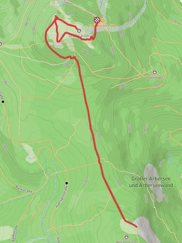
Großer Arbersee, Stallriegel Gipfelstation and Großer Arber Loop via Arberweg
10.8 km
~3 hrs 19 min
707 m
“Journey through Bavaria's natural beauty, history, and diverse landscapes on this captivating 11 km trail.”
Starting near the charming town of Regen, Germany, the Großer Arbersee, Stallriegel Gipfelstation, and Großer Arber Loop via Arberweg is a captivating 11 km (6.8 miles) loop trail with an elevation gain of approximately 700 meters (2,297 feet). This medium-difficulty hike offers a blend of natural beauty, historical significance, and a variety of landscapes that will keep any hiker engaged.
### Getting There
To reach the trailhead, you can either drive or use public transport. If driving, head towards Regen and follow signs to the Großer Arbersee. There is ample parking available near the lake. For those using public transport, take a train to Regen and then a bus towards Bayerisch Eisenstein, getting off at the Großer Arbersee stop. The trailhead is conveniently located near the lake, making it easily accessible.
### Trail Highlights
#### Großer Arbersee
The trail begins at the picturesque Großer Arbersee, a serene lake surrounded by dense forest. This glacial lake is a perfect spot to start your hike, offering stunning reflections of the surrounding mountains. The lake is home to a variety of bird species, so keep an eye out for kingfishers and herons.
#### Ascent to Stallriegel Gipfelstation
From the lake, the trail ascends towards the Stallriegel Gipfelstation. This section is moderately steep, gaining about 400 meters (1,312 feet) in elevation over 3 km (1.86 miles). The path is well-marked and winds through a dense forest of spruce and fir trees. Along the way, you might spot deer and other wildlife. The Stallriegel Gipfelstation offers panoramic views of the Bavarian Forest and is a great spot for a short break.
#### Großer Arber Summit
Continuing from the Stallriegel Gipfelstation, the trail leads you to the summit of Großer Arber, the highest peak in the Bavarian Forest at 1,456 meters (4,777 feet). This section is about 2 km (1.24 miles) long and gains another 300 meters (984 feet) in elevation. The summit offers breathtaking 360-degree views, including sights of the Czech Republic to the east. On clear days, you can even see the Alps in the distance.
### Historical Significance
The Großer Arber region has a rich history. During the Cold War, the summit was used as a listening post by both NATO and the Warsaw Pact due to its strategic location. Remnants of these installations can still be seen today, adding a layer of historical intrigue to your hike.
### Descent and Return Loop
The descent from Großer Arber is gradual and takes you through alpine meadows and mixed forests. This section is about 6 km (3.73 miles) long and loops back towards the Großer Arbersee. Along the way, you'll pass by several small streams and might encounter wildflowers such as alpine asters and edelweiss, especially in the late spring and summer months.
### Navigation and Safety
For navigation, it's highly recommended to use the HiiKER app, which provides detailed maps and real-time updates. The trail is generally well-marked, but having a reliable navigation tool ensures you stay on the right path. Always carry sufficient water, snacks, and a first-aid kit. Weather in the mountains can change rapidly, so bring appropriate clothing and check the forecast before you start.
This trail offers a perfect blend of natural beauty, wildlife, and historical significance, making it a must-do for any hiking enthusiast visiting the Bavarian Forest.
Reviews
User comments, reviews and discussions about the Großer Arbersee, Stallriegel Gipfelstation and Großer Arber Loop via Arberweg, Germany.
4.0
average rating out of 5
4 rating(s)


