9.0 km
~2 hrs 21 min
336 m
“Explore natural beauty and history on the moderate 9 km Sulz and Langenhard Loop near Gengenbach, Germany.”
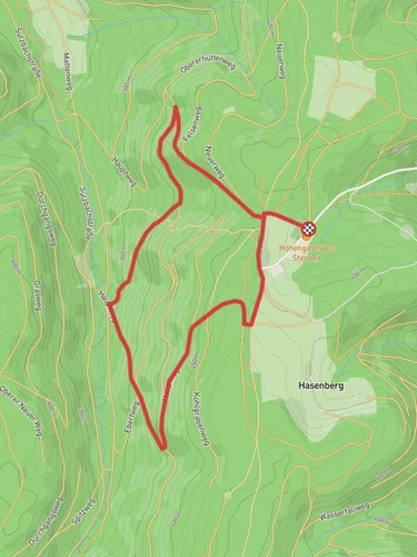
Starting near Ortenaukreis, Germany, the Sulz and Langenhard Loop via Scheibhalde is a picturesque 9 km (5.6 miles) loop trail with an elevation gain of approximately 300 meters (984 feet). This medium-difficulty trail offers a blend of natural beauty, historical significance, and a moderate challenge suitable for most hikers.
### Getting There To reach the trailhead, you can drive or use public transport. If driving, set your GPS to the nearest known address: Scheibhalde, 77723 Gengenbach, Germany. There is parking available near the trailhead. For those using public transport, take a train to Gengenbach station. From there, you can catch a local bus or taxi to Scheibhalde.
### Trail Navigation For navigation, it is highly recommended to use the HiiKER app, which provides detailed maps and real-time updates to ensure you stay on track.
### Trail Highlights The trail begins with a gentle ascent through dense forests, offering a serene start to your hike. After about 1.5 km (0.9 miles), you will reach the first significant landmark, the Scheibhalde viewpoint. This spot provides panoramic views of the surrounding valleys and is an excellent place for a short break.
Continuing along the trail, you will encounter a mix of forested paths and open meadows. Around the 4 km (2.5 miles) mark, you will come across the historic Sulz ruins. These remnants of an old castle offer a glimpse into the region's medieval past and are a fascinating stop for history enthusiasts.
### Flora and Fauna The trail is rich in biodiversity. In the spring and summer months, the meadows are adorned with wildflowers, while the forests are home to various bird species and small mammals. Keep an eye out for deer, which are commonly spotted in the early mornings or late afternoons.
### Midpoint and Elevation Gain At approximately 5 km (3.1 miles), you will reach the highest point of the trail, Langenhard. The elevation gain here is around 150 meters (492 feet) from the starting point. This section offers stunning views and is a great spot for photography.
### Descending and Completing the Loop The descent begins after Langenhard, leading you through more forested areas and eventually back to the starting point. The final 4 km (2.5 miles) are relatively easy, with a gentle decline that allows you to enjoy the surrounding nature without too much strain.
### Historical Significance The Ortenaukreis region has a rich history dating back to Roman times. The Sulz ruins are a testament to the area's medieval heritage, and the trail itself has been used for centuries by locals and travelers alike.
### Final Stretch As you approach the end of the loop, you will pass through a charming village where you can find local eateries and shops. This is a perfect opportunity to relax and enjoy some regional cuisine before heading back.
This trail offers a well-rounded hiking experience with its mix of natural beauty, historical landmarks, and moderate physical challenge. Whether you're a seasoned hiker or a casual walker, the Sulz and Langenhard Loop via Scheibhalde provides a memorable outdoor adventure.
Reviews
User comments, reviews and discussions about the Sulz and Langenhard Loop via Scheibhalde, Germany.
4.0
average rating out of 5
3 rating(s)


