6.5 km
~1 hrs 32 min
147 m
“Explore Saxony's scenic beauty on the 6 km Talsperre Rauschenbach loop, rich in nature and history.”
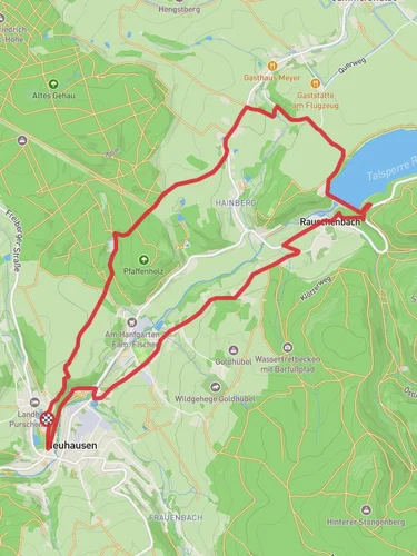
Starting near Mittelsachsen, Germany, the Talsperre Rauschenbach via Querweg trail offers a delightful 6 km (approximately 3.7 miles) loop with an elevation gain of around 100 meters (328 feet). This medium-difficulty trail is perfect for hikers looking to explore the scenic beauty of the Saxony region.
### Getting There To reach the trailhead, you can drive or use public transport. If driving, set your GPS to the vicinity of the Rauschenbach Dam, which is a well-known landmark in the area. For those using public transport, the nearest significant town is Neuhausen, from where you can take a local bus or taxi to the dam.
### Trail Overview The trail begins near the Rauschenbach Dam, a significant landmark in the region. The dam itself is an impressive structure, built in the 1960s, and serves as a crucial water reservoir for the area. As you start your hike, you'll be greeted by the serene waters of the dam, reflecting the surrounding forested hills.
### Flora and Fauna The trail meanders through dense forests, primarily composed of spruce and beech trees. Keep an eye out for local wildlife, including deer, foxes, and a variety of bird species. The forest floor is often carpeted with ferns and wildflowers, adding a splash of color to your hike.
### Key Landmarks - Rauschenbach Dam: Approximately 1 km (0.6 miles) into the hike, you'll have a fantastic view of the dam. Take a moment to appreciate the engineering marvel and the tranquil waters. - Querweg Junction: Around the 3 km (1.8 miles) mark, you'll reach the Querweg junction. This is a great spot to take a short break and enjoy a snack while soaking in the natural beauty. - Scenic Overlook: At about 4.5 km (2.8 miles), there's a scenic overlook offering panoramic views of the surrounding landscape. This is a perfect photo opportunity, so have your camera ready.
### Navigation and Safety The trail is well-marked, but it's always a good idea to have a reliable navigation tool. HiiKER is an excellent app for this purpose, providing detailed maps and real-time tracking. The terrain is generally moderate, but there are a few steep sections, so sturdy hiking boots are recommended.
### Historical Significance The region around the Rauschenbach Dam has a rich history. The dam itself was constructed during the Cold War era and played a vital role in water management for the region. The surrounding forests have been managed for centuries, with evidence of old logging routes and historical markers along the trail.
### Final Stretch As you loop back towards the starting point, the trail descends gently, offering a relaxing end to your hike. The final kilometer (0.6 miles) brings you back to the dam, where you can take a moment to reflect on your journey and perhaps enjoy a picnic by the water.
This trail offers a perfect blend of natural beauty, historical significance, and moderate physical challenge, making it a rewarding experience for any hiker.
Reviews
User comments, reviews and discussions about the Talsperre Rauschenbach via Querweg, Germany.
5.0
average rating out of 5
4 rating(s)


