14.2 km
~3 hrs 18 min
281 m
“Explore scenic landscapes, historic routes, and panoramic views on the 14 km Winterleitenweg and Jakobsweg trail.”
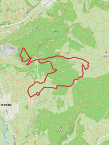
Starting near Main-Tauber-Kreis, Germany, the Winterleitenweg and Jakobsweg Main-Taubertal trail offers a delightful 14 km (approximately 8.7 miles) loop with an elevation gain of around 200 meters (656 feet). This medium-difficulty trail is perfect for those looking to explore the scenic beauty and historical richness of the region.
### Getting There To reach the trailhead, you can drive or use public transport. If driving, set your GPS to Main-Tauber-Kreis, Germany. For those using public transport, the nearest significant landmark is the Tauberbischofsheim train station. From there, local buses or a short taxi ride will get you to the trailhead.
### Trail Overview The trail begins with a gentle ascent, allowing you to ease into the hike. As you progress, you'll encounter a mix of forested paths and open fields, providing a variety of landscapes to enjoy. The initial 3 km (1.86 miles) will take you through dense woodlands, where you might spot local wildlife such as deer and various bird species.
### Historical Significance Around the 5 km (3.1 miles) mark, you'll come across a section of the trail that intersects with the historic Jakobsweg, or St. James' Way. This ancient pilgrimage route has been traveled by pilgrims for centuries, adding a layer of historical significance to your hike. Keep an eye out for the distinctive scallop shell markers that signify the Jakobsweg.
### Key Landmarks At approximately 7 km (4.35 miles), you'll reach a scenic viewpoint offering panoramic views of the Tauber Valley. This is an excellent spot for a break and some photography. Continuing on, the trail will lead you past several vineyards, showcasing the region's rich winemaking heritage.
### Navigation and Safety The trail is well-marked, but it's always a good idea to have a reliable navigation tool. HiiKER is highly recommended for this purpose, as it provides detailed maps and real-time updates. The terrain can be uneven in places, so sturdy hiking boots are advisable. Also, be prepared for varying weather conditions; layers are key.
### Flora and Fauna The latter part of the trail, around the 10 km (6.2 miles) mark, takes you through more open fields and meadows. Here, you can enjoy the sight of wildflowers in bloom during the spring and summer months. The diversity of plant life attracts a variety of butterflies and other insects, adding to the natural beauty of the hike.
### Final Stretch As you approach the final 2 km (1.24 miles), the trail descends gently back towards the starting point. This section is relatively easy and provides a nice cool-down after the more challenging parts of the hike. You'll pass through a small village where you can stop for refreshments before completing the loop.
This trail offers a perfect blend of natural beauty, historical significance, and moderate physical challenge, making it a rewarding experience for any hiker.
Reviews
User comments, reviews and discussions about the Winterleitenweg and Jakobsweg Main-Taubertal, Germany.
5.0
average rating out of 5
1 rating(s)


