6.7 km
~1 hrs 39 min
196 m
“Experience a 7-kilometer loop blending Spessart's beauty, historical intrigue, and moderate challenge near Flörsbachtal.”
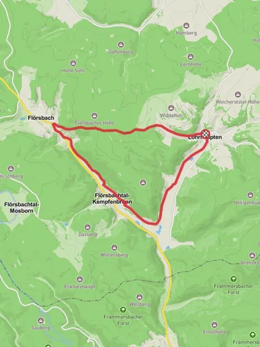
Starting near Main-Kinzig-Kreis, Germany, the Ortswanderweg Floersbachtal 6 is a delightful loop trail that spans approximately 7 kilometers (around 4.3 miles) with an elevation gain of about 100 meters (328 feet). This medium-difficulty trail offers a blend of natural beauty, historical significance, and a moderate challenge suitable for most hikers.
### Getting There To reach the trailhead, you can drive or use public transport. If driving, set your GPS to the vicinity of Main-Kinzig-Kreis, specifically near the town of Flörsbachtal. For those using public transport, the nearest significant landmark is the Flörsbachtal town center. From there, local buses or a short taxi ride can get you to the trailhead.
### Trail Navigation Using HiiKER for navigation is highly recommended to ensure you stay on the correct path and to make the most of your hike. The trail is well-marked, but having a reliable navigation tool can enhance your experience.
### Trail Highlights As you embark on the Ortswanderweg Floersbachtal 6, you'll find yourself immersed in the serene beauty of the Spessart region. The trail meanders through dense forests, open meadows, and along picturesque streams. Early in the hike, you'll encounter a charming wooden bridge crossing a small brook, a perfect spot for a quick photo or a moment of reflection.
### Flora and Fauna The trail is rich in biodiversity. Keep an eye out for native wildlife such as deer, foxes, and a variety of bird species. The forested sections are home to ancient oak and beech trees, providing ample shade and a sense of tranquility. In the spring and summer months, the meadows burst into a riot of wildflowers, adding vibrant colors to your journey.
### Historical Significance The region around Main-Kinzig-Kreis has a deep historical background. As you hike, you'll come across remnants of old stone walls and possibly even ancient boundary markers that date back to medieval times. These historical artifacts offer a glimpse into the area's past, where it served as a significant route for traders and travelers.
### Points of Interest Around the halfway mark, approximately 3.5 kilometers (2.2 miles) into the hike, you'll reach a scenic viewpoint that offers panoramic views of the surrounding Spessart hills. This is an excellent spot to take a break, enjoy a snack, and soak in the natural beauty.
### Elevation and Terrain The trail's elevation gain is moderate, with a total ascent of about 100 meters (328 feet). The terrain varies from flat sections to gentle inclines, making it accessible for hikers with a reasonable level of fitness. The path is mostly dirt and gravel, with some rocky sections, so sturdy hiking boots are recommended.
### Practical Tips - Water and Snacks: Ensure you carry enough water and some snacks, especially if you plan to take your time and enjoy the scenery. - Weather: Check the weather forecast before heading out. The trail can be muddy after rain, so appropriate footwear is essential. - Wildlife: While wildlife sightings are a highlight, remember to keep a respectful distance and not to feed any animals.
### Completing the Loop As you near the end of the loop, the trail gently descends back towards the starting point near Flörsbachtal. The final stretch offers a peaceful walk through a shaded forest, providing a cool and relaxing end to your hike.
This trail offers a perfect blend of natural beauty, moderate physical challenge, and historical intrigue, making it a rewarding experience for any hiker.
Reviews
User comments, reviews and discussions about the Ortswanderweg Floersbachtal 6, Germany.
5.0
average rating out of 5
2 rating(s)


