Bad Soden - Salmuenster to Marjoss via Kulturweg Jossgrund
14.2 km
~3 hrs 27 min
364 m
“Explore lush forests, historic ruins, and diverse wildlife on this 14 km scenic, moderately difficult trail.”
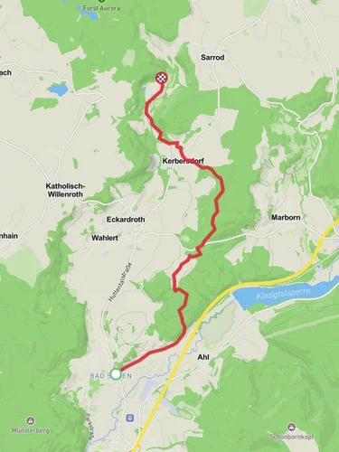
Starting near Main-Kinzig-Kreis, Germany, the trail from Bad Soden-Salmünster to Marjoss via Kulturweg Jossgrund spans approximately 14 km (8.7 miles) with an elevation gain of around 300 meters (984 feet). This point-to-point trail is rated as medium difficulty, making it suitable for moderately experienced hikers.
### Getting There To reach the trailhead, you can take a train to Bad Soden-Salmünster station, which is well-connected to major cities like Frankfurt and Fulda. From the station, it's a short walk to the starting point. If you're driving, parking is available near the trailhead in Bad Soden-Salmünster.
### Trail Overview The trail begins in the charming town of Bad Soden-Salmünster, known for its therapeutic spas and historic architecture. As you set off, you'll traverse through lush forests and open meadows, offering a mix of shaded and sunlit paths. The initial part of the trail is relatively flat, making for a gentle warm-up.
### Significant Landmarks and Nature Around the 3 km (1.9 miles) mark, you'll encounter the Kulturweg Jossgrund, a cultural trail that highlights the historical and natural significance of the region. This section is rich with interpretive signs that provide insights into the local history, flora, and fauna. Keep an eye out for the diverse bird species that inhabit this area, as well as occasional sightings of deer and other wildlife.
### Elevation Gain and Terrain As you progress, the trail begins to ascend gradually. By the time you reach the 7 km (4.3 miles) point, you'll have gained a significant portion of the 300 meters (984 feet) in elevation. The terrain here becomes a bit more challenging, with steeper inclines and rocky sections. Good hiking boots are recommended for this part of the trail.
### Historical Significance The region is steeped in history, with several points of interest along the way. One notable landmark is the ruins of a medieval castle, located around the 10 km (6.2 miles) mark. This site offers a glimpse into the area's feudal past and provides a great spot for a rest and some photos.
### Final Stretch to Marjoss The last 4 km (2.5 miles) of the trail take you through more forested areas and eventually open up to the picturesque village of Marjoss. This section is mostly downhill, allowing for a more relaxed finish. Marjoss itself is a quaint village with traditional German architecture and a few local eateries where you can enjoy a well-deserved meal.
### Navigation For navigation, it's highly recommended to use the HiiKER app, which provides detailed maps and real-time updates to ensure you stay on track. The trail is well-marked, but having a reliable navigation tool can enhance your hiking experience.
### Wildlife and Flora Throughout the hike, you'll be surrounded by a variety of plant species, including oak, beech, and pine trees. In spring and summer, the meadows are adorned with wildflowers, adding a splash of color to the landscape. The diverse ecosystem supports a range of wildlife, so keep your camera ready for unexpected encounters.
This trail offers a balanced mix of natural beauty, historical intrigue, and moderate physical challenge, making it a rewarding experience for those looking to explore the scenic and cultural richness of the Main-Kinzig-Kreis region.
Reviews
User comments, reviews and discussions about the Bad Soden - Salmuenster to Marjoss via Kulturweg Jossgrund, Germany.
0.0
average rating out of 5
0 rating(s)


