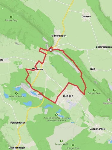
10.1 km
~2 hrs 20 min
194 m
“Explore Lower Saxony's scenic landscapes on a 10 km trail featuring Rothesteinhöhle cave and panoramic views.”
Starting near Lower Saxony, Germany, this 10 km (approximately 6.2 miles) point-to-point trail offers a moderate hiking experience with an elevation gain of around 100 meters (328 feet). The trailhead is accessible by car or public transport, with the nearest significant landmark being the town of Donser Wald. If you're traveling by public transport, you can take a train to the nearest station in Alfeld (Leine) and then a local bus or taxi to Donser Wald.
Trail Overview
The trail begins in the serene forested area of Donser Wald, known for its dense canopy of beech and oak trees. As you start your hike, you'll be greeted by the sounds of chirping birds and the rustling of leaves, creating a tranquil atmosphere. The initial part of the trail is relatively flat, making it a good warm-up for the more undulating terrain ahead.
Rothesteinhöhle Cave
Approximately 4 km (2.5 miles) into the hike, you'll reach one of the trail's most significant landmarks, the Rothesteinhöhle cave. This natural limestone cave is a fascinating geological formation and offers a cool respite from the hike. The cave has historical significance as it was used by early humans for shelter and later by medieval hermits. Make sure to bring a flashlight if you plan to explore the cave's interior, as it can be quite dark inside.
Scenic Views and Wildlife
Continuing on, the trail gradually ascends, offering scenic views of the surrounding Lower Saxony countryside. Around the 6 km (3.7 miles) mark, you'll reach a vantage point that provides panoramic views of the rolling hills and lush forests. This is a great spot to take a break and enjoy a snack while soaking in the natural beauty.
Wildlife enthusiasts will be delighted to know that this area is home to a variety of animals, including deer, foxes, and numerous bird species. Keep your eyes peeled and your camera ready, as you might spot a red kite soaring overhead or a shy roe deer darting through the underbrush.
Final Stretch to Holzen
As you approach the final stretch of the trail, the terrain becomes more varied with a mix of gentle slopes and flat sections. The last 2 km (1.2 miles) lead you through a picturesque valley dotted with wildflowers in the spring and summer months. The trail concludes in the quaint village of Holzen, where you can find local eateries and inns to rest and refuel.
Navigation and Safety
For navigation, it's highly recommended to use the HiiKER app, which provides detailed maps and real-time updates. The trail is well-marked, but having a reliable navigation tool ensures you stay on track and can easily find points of interest along the way.
Getting There
To reach the trailhead, you can drive to Donser Wald, where parking is available. If using public transport, take a train to Alfeld (Leine) and then a local bus or taxi to Donser Wald. The trail ends in Holzen, where you can catch a bus or arrange for a taxi back to your starting point or nearest train station.
This hike offers a perfect blend of natural beauty, historical intrigue, and moderate physical challenge, making it an excellent choice for hikers looking to explore the scenic landscapes of Lower Saxony.
Reviews
User comments, reviews and discussions about the Donser Wald to Holzen Walk via Rothesteinhöhle, Germany.
5.0
average rating out of 5
1 rating(s)


